
After spending five days in the Victorian Alps training for the 3 Peaks Challenge, Brendan and I are back in Melbourne. Join us now as we recount the trip.
With Brendan at a lunch appointment until early afternoon I drove up to Porepunkah by myself with the aim of getting some photography done for the website. While the Hume Freeway is the most direct route and certainly the quickest way of getting to the high country, it certainly isn’t the most interesting. After turning onto the Hume I flicked cruise control on and turned on some music in order to keep myself awake.
After stopping in Myrtleford for some shopping I headed out to Riverview Caravan Park in Porepunkah and set up my tent. With Brendan still a few hours away I jumped back in the car and drove up to Mt. Buffalo to get some photos and notes for the website. Stay tuned for the Mt. Buffalo climb, coming soon.
Brendan arrived at the camp ground around 5pm and we set his tent up before organising some dinner. There’s something about camping that makes it far easier to go to bed at a reasonable time than when you are at home. With the intention of getting up early so as to beat the heat of the following day, we called it a night at about 9.30pm.
Route: Porepunkah to Mt. Hotham, return
Distance: 130km
Duration: 5 hours 45 minutes
At 5:15am the next morning we woke and got ready for the day’s ride. It was supposed to be about 34 degrees and so, with an ascent of Mt. Hotham planned, we were pretty keen to avoid the heat of the day.
We rolled out at 6:30am and as we rode through Bright we noticed a few spots of rain around. In fact it was pretty miserable for most of the ride out to Harrietville and we were a little concerned that the climb wouldn’t be all that fun if the weather conditions prevailed.
Luckily the weather held out for the most part and after a brief stop in Harrietville we began climbing. Unfortunately my knee didn’t hold out, with an excruciating stabbing pain in my right knee troubling me for most of the climb. I had managed to get through the first 10km and The Meg with little trouble but by the end of the middle false-flat section, I was starting to feel it. It’s hard to describe the pain but it felt like I couldn’t put any pressure on my right leg, especially when I was out of the saddle.
The pain certainly made CRB Hill and the Diamantina even more challenging than they are already but, just as soon as I was sure I couldn’t finish the climb, the pain would subside completely.
Mt. Hotham is certainly among the most challenging climbs in Victoria, not least of all due to the ridiculous last 10km which is incredibly steep in parts. In terms of scenery I’m not aware of any other climb quite like it in Victoria – the way that the road emerges from the treeline at Mt. St. Bernard is quite eerie.
The last 10km of the climb, while being very steep in some parts, also has a couple of sharp downhills which, while being quite welcome on the way up, are a bit of a kick in the pants when you are supposed to be going “down” the hill.
We reached the summit in a little over two hours, a bit faster than my last attempt, and after rolling down to The General for a couple of stamps in our Alpine Ascent Challenge passports and a bite to eat, we saddled up for the ride back down the hill.
The break at Hotham hadn’t helped my leg any and with very strong head- and cross-winds on the way out of the Hotham village, I was feeling very sore and mightily concerned about the epic ride in less than two weeks time.
But, as it had done on sections of the way up, my knee suddenly stopped hurting somewhere after Harrietville. I was able to get home quite comfortably in the end but I was no less concerned about a flare-up during 3 Peaks.
After showering and a brief rest we had planned to take the inflatable boat out on the Buckland River but the weather had other ideas. The light sun-shower that had greeted us as we rolled back into camp quickly turned into a fully-fledged torrential downpour and we found ourselves hiding in Brendan’s car. After a while we decided to watch crap TV in the camp ground’s Recreation Room before heading out to the local pub for a bite to eat.
The next morning we woke around 8am with the rain still pouring down outside. It had rained for 16 hours straight and the Buckland River was noticeably higher than the previous day.
With a ride off the cards due to the inclement weather we decided to scope out the sections of the 3 Peaks Course that we hadn’t ridden and Brendan was nice enough to help with photography and note-taking for a couple more climbs for the site.
We drove straight out to Hotham in the driving rain and with the thick fog that surrounded the mountain, it was a struggle to see 10 metres in front of the car. As we crested the hill and drove down to Dinner Plain the weather cleared somewhat.
I’d never been beyond Mt. Hotham and I have to say that there is some simply stunning scenery out Omeo way. The rolling hills between Dinner Plain and Omeo make for an amazing backdrop and the town of Omeo is so remote, set in a stunning little valley.
As if the roads couldn’t get any better, as soon as we left Omeo and turned onto the Mitta Mitta Road we were privy to quite an amazing part of the world. Clinging onto the ridge of the hills between Omeo and Mitta Mitta, the road winds stunningly through some of the most amazing scenery I’ve ever seen. For a fair stretch of the road one can see a gorgeous valley off to the right that hosts the Mitta Mitta River. I hope you get a chance to see the videos that we took of that area because it is simply amazing.
However, things take a turn for the worse when the Bogong High Plains Road starts, for cyclists at least. As soon as we turned the corner we saw the road shoot skyward at at least 10%. Not what you want to see after 200km of riding. In fact the majority of the last 30km back up to Falls Creek is painfully steep. We noticed several sections in excess of 10% and the official profile has the average gradient of that last climb at around 6-7%. It is going to a serious challenge to complete the course on March 7.
As we neared the top of Falls Creek the weather once again took a turn for the worse. The wind picked up, the rain started coming in sideways, literally, and it was so foggy that I drove into the Rocky Valley Storage Area carpark without even realising that I had turned off the road. Visibility was again down to around 10 metres. If the weather on March 7 is anything like it was the other day then we are in even more strife than we already were.
Back down from Falls, the weather was fine, albeit a little overcast. We took some photos and notes of the backside of the Tawonga Gap climb for the website before driving back to camp. Dinner was followed by another early night in preparation for the following day’s ride.
Route: Porepunkah to Falls Creek, return
Distance: 140km
Duration: 6 hours 9 minutes
With the weather not forecast to be as hot as the day of the Hotham ascent we decided to roll out a little bit later. By 10am we were moving and rolling steadily out to the first climb of the day, the Tawonga Gap.
After grabbing a couple of apples from the fruitmonger at Germantown we turned left and headed toward the Gap. While the first seven kilometres or so aren’t at a noticeable incline they still kept us at a fairly pedestrian pace. When the climbing began we just sat back and got into a rhythm until we reached the top.
The descent into Mt. Beauty is a little bit sketchy but we negotiated it fine and stopped briefly in town for a Powerade. After we were sufficiently hydrated we jumped back on our bikes and rode the 16km to the base of the Falls Creek climb.
The road from Mt. Beauty to the Bogong Alpine Village is probably my favourite road to ride on. It’s quiet, undulating and it winds through some truly breathtaking scenery. At Bogong we paused briefly for a bite to eat before heading to the base of the Falls climb. Having ridden the climb once before we knew that it wasn’t the most challenging climb around but, after completing it in exactly an hour last year, we were keen to go under that this year.
The climb up to Falls is predictably picturesque and, while the first 9km aren’t that challenging, the final section from the tollbooth kicks up a little bit. In the end we managed to reach the summit in 59 minutes feeling good and in need of something to eat.
Unfortunately most of the shops in Falls Creek seem to close over summer and so, after getting a couple of stamps for out Alpine Ascent passports we rolled back down the hill.
The way back from Bogong to Mt. Beauty is certainly a lot faster than the approach to Falls and we got into town in no time.
We took the opportunity to get a bit more to eat in Mt. Beauty, slamming down a couple of caffeinated beverages and assorted pastries before attempting the steeper side of the Tawonga Gap.
After 100km of riding I was expecting the climb to be extremely challenging but by finding a steady rhythm and just spinning away we reached the top with very little fuss at all. Sure, we aren’t going to be challenging any A grade riders with a time of 38 minutes 40 seconds but that was never the intention.
It’s easy to get wrapped up in superlatives in the heat of the moment but, several days later, I would still have to say that the descent from the Tawonga Gap into Germantown is the most enjoyable I’ve ever done. Beautiful sweeping turns, great road surface and stunning scenery makes for a truly memorable descent. We flew back onto the Great Alpine Road and, feeling mysteriously strong, we decided to ramp the pace up for the last 15km. I ended up sitting at around 36km for most of the way back into camp, touching 42.5km at one point. Not bad considering that we had already ridden 130km and that my knee was excruciating several days before.
On that point, it’s amazing what a bit of tape can do. Whether or not the effect was pschosomatic I’m not quite sure but I got through 140km without a scrap of pain at all thanks to some strapping tape above my right knee.
After our mini-3 Peaks Challenge we headed into town for some dinner and Brendan headed back to Melbourne to get some errands done. I made it an early night in the hope of getting out to Mt. Buffalo in the morning but when morning came I wasn’t feeling all that motivated so I just packed up the car and headed home.
So, one ride of 130km and one of 140km and several significant climbs throughout. Sure, we probably could have got some more riding in but I think we did enough to give ourselves a bit of confidence come March 7. Sure, it’s going to be a ridiculously difficult day and we’re still not 100% confident that we will make it but we certainly feel better than we did a few weeks ago.
The plan is to do one more long ride before we taper our training for the final week. After that, well, we’ll see what happens. Who knows, we might even be able to finish the 3 Peaks Challenge.
9 days to go…
More from The Climbing Cyclist
 January 3, 2011 Episode 8: Ups and downs in the Victorian Alps
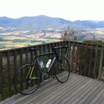 January 7, 2012 Episode 8: a warm welcome to the Alps
 March 6, 2010 The calm before the storm
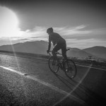 March 14, 2014 3 Peaks Challenge 2014
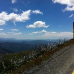 February 4, 2013 3 Peaks Challenge 2013: what to expect
I was out there that same weekend! On the rainy day we did Bright – Falls Creek return and I crashed on greasy roads during the final descent of Tawonga. The region has such a variety of weather conditions – I think the real challenge of the Three Peaks will be managing the elements.