
Route: Queenstown, Arrowtown and Frankton loop, via Coronet Peak
Distance: 60.5km
Duration: 2 hours 55 minutes

Since we last spoke, Sharon and I have spent two full days in the bustling adventure capital of Queenstown, having driven from Oamaru yesterday morning. For anyone that’s interested in heading over to this part of the world at some point, I’d thoroughly recommend the aforementioned drive. It’s a good four hours behind the wheel but the variety of scenery you’ll see along the way is quite breathtaking – sweeping gorges, emerald-coloured rivers, sheer cliffs and vast tracts of farmland. There are certainly worse parts of the world to travel through.
Having settled in to Queenstown last night, Sharon and I spent the morning rafting on the Kawarau River. It was a lovely couple of hours spent on the river and quite hard work too! After returning to our accommodation, I felt as if another ride might be on the cards. I got my stuff together and just as I was about to walk out the door, it started to drizzle with rain. It was that sort of rain that you don’t even notice once you are riding so I decided to head out anyway.

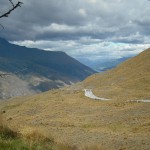
The weather behaved itself as I headed north out of Queenstown – I was headed to the nearby ski field of Coronet Peak and a climb I really had no idea about. I knew it was about 8km long but I couldn’t find any information about the average gradient or anything like that. My only piece of information was that the summit was at 1360m and Queenstown was at 310m or something similar. If I was going to climb over 1000m in 8km I’d be looking at an average gradient of well over 10% – not fun! As I approached the start of the climb, I didn’t feel any more reassured. The road disappeared sharply into the distance and I wondered silently what I had gotten myself into.
It seems to be a bit of a phenomenon in New Zealand – where Australian road engineers seem to prefer to make climbs longer and less steep (Mt. Baw Baw excluded) their New Zealand counterparts seem to be less concerned about us cyclists. Wikipedia will tell you that the world’s steepest street is in Dunedin and when Sharon and I were in Oamaru we saw many streets that went straight up nearby hills well in excess of 20%!

Luckily though, I didn’t have to grind my way up 8km of >10% gradient but grinding was still very much required. The average gradient of the climb must have been around 7-8% and with a very rough road surface with plenty of grit, I was hardly setting any best times. To add to my woes, the rain got heavier and heavier as I climbed until, at the snowfields, it was raining quite heavily and the view I had worked hard for was partially obscured by fog and rain. The descent was a bit of a drag as well, with most of the 8km spent clasping the breaks tightly for fear of slipping and sliding into oblivion.
I shouldn’t really complain though. I consider myself very fortunate to have the opportunity to cycle in New Zealand and with the amazing scenery around Queenstown it made for some spectacular riding. I got to the bottom of the climb utterly drenched and I started heading back the way I came – which would have made it a 32km ride, hardly substantial – until I realised that I wasn’t going to get any wetter. I turned around and continued toward Arrowtown with a tailwind pushing me along quite swiftly. In fact, by the time I got to the main turn off near Arrowtown I was almost completely dry.

I turned right, heading toward Lake Hayes and by the time I had reached the main road back into Queenstown, the rain had returned, heavier than ever. For those that don’t know anything about Queenstown, it’s a busy, bustling, tourist-clogged theme park full of hire cars, campervans and tour buses. This fact, combined with a narrow road into town with a pretty rough surface and the driving rain, made the last 15km back to our accommodation quite challenging. But as I’ve already said, when you’re riding in New Zealand’s mystical South Island, you should probably take what you can get!
The final challenge of the day was climbing up the street that we are staying on. It starts off pretty gently at about 10% and by the time you get to the front door of the lodge, you’re looking at 100m in excess of 20%! Nothing like a nice warm down to finish the ride.

Tomorrow morning we have a long drive ahead of us, heading out to the west coast of the South Island – glacier country. With any luck I’ll be able to ride the first section of tomorrow’s drive – the 70km over Cardrona to Wanaka – another amazing road if the stories we’ve heard are true.
Thanks again for reading and I hope to check in again in the next few days. Don’t forget you can get involved in the TCC community over at Facebook and Twitter. Just follow the snazzy links at the top left of the page or click on the ‘Like’ and ‘Tweet’ buttons below.
54 days to go…
More from The Climbing Cyclist
 January 19, 2011 Episode 14: The mighty Crown Range
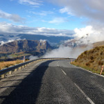 March 13, 2015 Cycling New Zealand 2015: climbing Coronet Peak
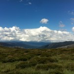 January 9, 2012 Episode 9: backing up with the Back of Falls
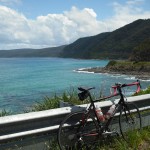 November 19, 2011 Episode 1: the Great Ocean Road ride
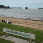 January 25, 2011 Episode 15: Back in the saddle
2 Replies to “Episode 13: Adventure capital climbing”