

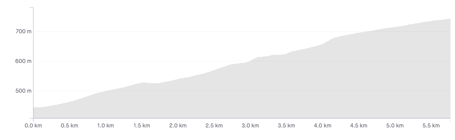
Length: 5.9km
Average gradient: 5.2%
Elevation gain: 308m
Introduction
Located roughly 15km south east of Ballarat, Mt. Buninyong is famous for hosting the Australian National Road Race Championships on its lower slopes. While the Nationals course only takes the riders up the first 3km of the climb, Mt. Buninyong Road continues for another couple kilometres, taking in some amazing views on its way to the top of the extinct volcano.
The start
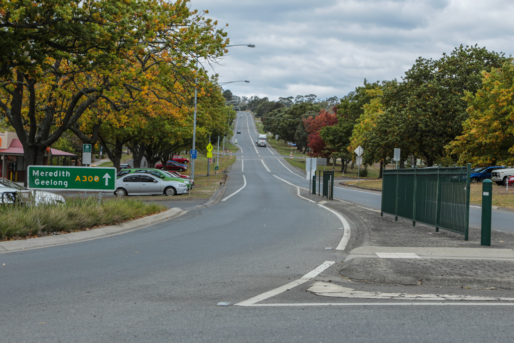
The Mt. Buninyong climb starts at the eastern exit of the roundabout in the middle of Buninyong — the intersection of the Midland Highway (A300, seen below) and Geelong Road/Warrenheip Road (C294).
The finish
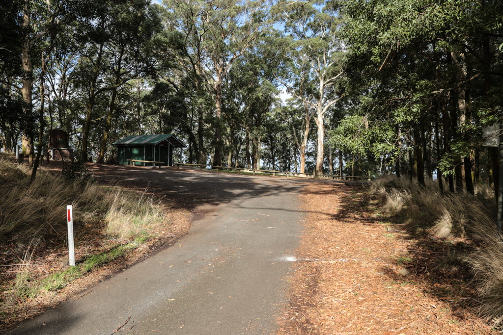
The Mt. Buninyong climb ends at the first carpark at the summit.
At a glance
- A variable climb with some great views in its final 2.8km.
- Take a left onto Mt. Buninyong Road after 1.5km to continue the climb.
- Be sure to take the right fork at the 4.1km mark when the road splits.
- Be careful of the intersection at the 5.3km mark.
Climb details
As soon as you exit the roundabout and head up the Midland Highway you’ll be climbing at around 5%. The first section of the climb is dead straight and you can see the road get steeper as it works its way up the hill. After 400m of climbing the gradient increases to around 7-8% and stays that way for the next 700m or so.
After 1.1km the road flattens off slightly as you approach the Mt. Buninyong Road turn-off at the 1.5km mark. After taking the left-hand turn you’ll notice that the road is more or less flat for a brief moment before kicking back up to about 4-5%. You’ll bend around to the right after 1.8km and shortly after that you’ll see a sign on the left designating the start of the Nationals KOM.
From here you’ll be able to see the road stepping up over the next few hundred metres. You’ll climb at about 5% to the 2.1km mark at which point the road will flatten of briefly, before heading up for another 200m. At 2.3km the road flattens off again before climbing once more.
The gradient at the 2.6km mark is around 7% and another 200m later you’ll reach a slight crest and the top of the Nationals KOM. Some 100m up the road, 3km from the start of the climb, you’ll reach the intersection with Yendon Number One Road. This is where the Nationals course heads left, away from the mountain, while the road (and the climb) continues upward.
Beyond the intersection Mt. Buninyong Road gets noticeably narrower and it carries far less traffic. You’ll take a sharp right turn at the 3.1km mark and as the road straightens out you’ll be able to see the communications towers at the summit, right in front of you.
The road’s more or less flat at the 3.4km mark but when you turn right 100m later, it kicks up sharply, briefly sitting at around 8-9%. But then it flattens off again to about 2-3% as you enter the Mt. Buninyong Scenic Reserve after 3.7km.
As you enter the reserve the gradient starts to increase slightly and at the 4km mark it’s hovering at around 8%. Roughly 100m later you’ll notice that the road splits in two: the right-hand lane going up the mountain, the left-hand lane reserved for those coming down. As you head up to the right the gradient is still around 8% and it stays that way until the road bends around to the right after 4.5km of climbing.
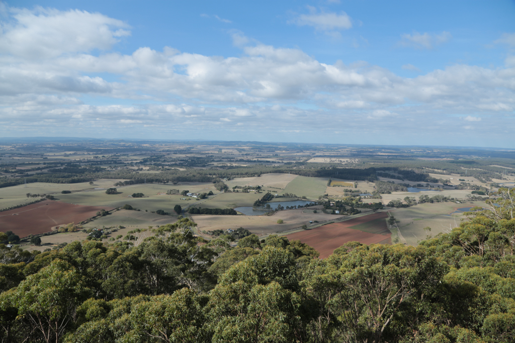
From this point the road flattens off to about 4-5% and you’ll start to get a sense of just how gorgeous the upper slopes of this climb actually are. The road flattens off even further as you bend around to the left after 4.8km, after which the gradient increases again. From this point on you’ll get a chance to check out the terrific views over to your right; views that only get better as you get closer to the summit.
The road flattens off again after making it around that left hander and when you reach the 5.3km mark you’ll cross the single-lane descent road. You have right of way as you head up the hill but be careful: it’s a blind corner in both directions and it pays to take it easy through here just in case.
Over the final 600m of the climb the road corkscrews its way anti-clockwise to the summit at an easy gradient that will allow you to appreciate just how good the views are. The climb ends when you reach the carpark after 5.9km. Be sure to head around to the left and climb the observation tower when you get there –the views are more than worth the effort!
Profile
Location
Buninyong is located roughly 120km west-north-west of Melbourne and roughly 10km south of the regional centre of Ballarat. To get to Buninyong from Melbourne, take the Western Highway out of town and take a left onto the Old Melbourne Road just before Ballarat. From there turn right onto Mt. Warrenheip Road, before taking Navigators Road, Yankee Flat Road, Gear Avenue and then the Geelong Road into Buninyong.
Times
A Strava segment for the full Buninyong to Mt. Buninyong climb can be found here. A Strava segment for the climb from Yendon Number One Road to the summit can be found here.
Rode this for the first time on the weekend. Really enjoyable climb overall, especially once you keep right for the real Mt B, as the first KOM stretch was fairly busy with traffic. Great views, and lots of space to bomb the descent as well.
Have done this ride many of times, usually park in Ballarat and make my way to the summit along Yankie flat road. The views are very rewarding and roads are very quiet, well worth a day trip from Melbourne!
Climbed a number of times recently. Considerable gravel on road due to recent heavy rains and lots of rabbits & wallabies on the road, particularly at dusk/dawn, keep that in mind as you descend.