

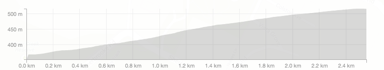
Length: 2.5km
Average gradient: 6.8%
Elevation gain: 169m
Introduction
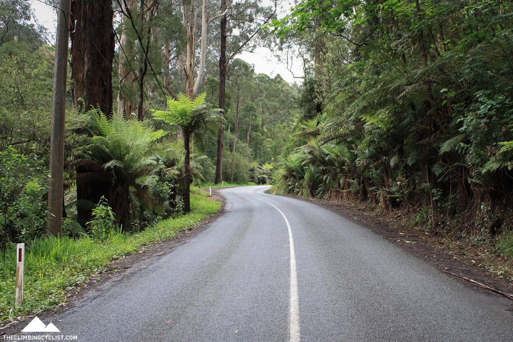
Among the most popular climbs in the Dandenong Ranges National Park, Perrins Creek Road might only be short but it’s also deceptively challenging. It also happens to be one of the most scenic climbs in the Dandenongs, with ferns and native gums crowding the road all the way up.
The start
The Perrins Creek Road climb starts at the intersection of Perrins Creek Road and Sassafras Creek Road/The Crescent, when the latter is on the left. While Perrins Creek Road is uphill for 200m before that intersection, it’s widely accepted that the climb proper starts at the intersection.
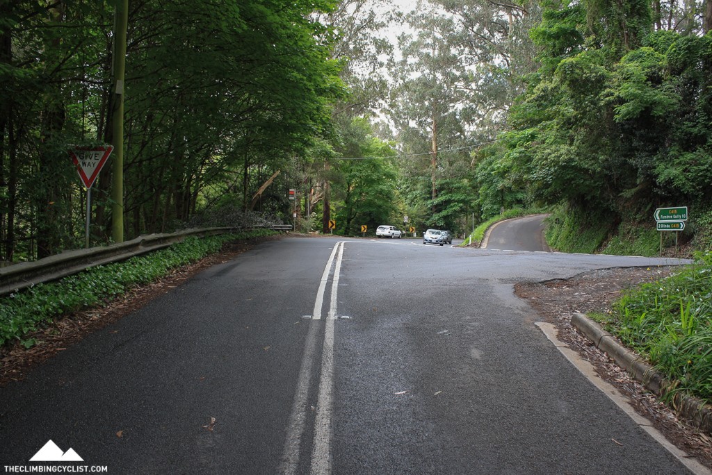
The finish
The Perrins Creek Road climb ends at a T-intersection with the Mt. Dandenong Tourist Road.
At a glance
- A short but deceptively challenging climb with some of the Dandenongs’ most impressive scenery.
- The gradient is largely consistent at around 6-7% most of the way up.
- There are two brief flatter sections (at 700m and 1.5km).
- There are two brief steeper sections (at the 1.8km hairpin and on the final corner).
Climb details
You get a fairly good idea of the gradient of this climb as soon as you leave Sassafras Creek Road/The Crescent behind you, with the road heading upwards at roughly 6-7%.
The grade stays relatively consistent most of the way up, aside from a couple of short, steeper ramps and the odd flatter section. One of those flatter sections comes after 700m when the gradient drops to around 3-4% but 100m later you’re back climbing at around 6%.
After a couple of gentle bends the road flattens off again slightly, this time after 1.5km, and for the next few hundred metres the climbing feels marginally easier.
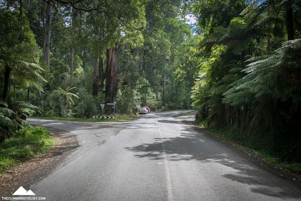
After 1.8km the road doubles back on itself, heading sharply around to the left as it crosses a small creek. This is the steepest part of the climb with the gradient touching 10% on the inside of the bend. But as the road straightens out, the gradient returns to around 7% as the end of the climb approaches.
After winding gently from side to side for a few hundred metres, the road kicks up slightly for the final right-hand bend which takes you to the end of the climb at the Mt. Dandenong Tourist Road.
Profile
Location
Perrins Creek Road is just one of many great climbs in the Dandenong Ranges National Park, roughly 40km east of Melbourne’s CBD. Popular routes out to the Dandenongs include Burwood Highway, Canterbury Road, Mitcham Road/Boronia Road, Mountain Highway and a combination of these.
Perrins Creek Road is most commonly accessed from the Mt. Dandenong Tourist Road (that is, by descending the climb then heading back up it) and isn’t far from the top of the Dandenongs’ most popular climbs, The 1 in 20 and The Wall.
The climb can also be accessed through the nearby towns of Kallista or Monbulk, taking you up towards Olinda and the upper reaches of the Dandenongs.
Times
The Strava segment for the Perrins Creek Road climb can be found here.
I finally hit this climb this week, and to be honest.
I’m kicking myself for waiting until now, what a lovely experience, traversing through this picturesque landscape was one of the most enjoyable climbs I’ve done.
I have to admit I think this might become a regular training inclusion.
I have to ask about Alexandra/ mast gully road.
I took a turn for a little exploring. Omg I wasn’t expecting what came as the road continued.
I opted out of terry’s avenue, but maybe I should have done it instead.
Have you climbed that one Matt ?
Thanks for adding this climb Matt. Haven’t done it for a while, but it’s one climb that always hurts me (more so, if I go up Olinda Cres afterwards).
I heard that certain Tour De France riders have done 16 laps of the Perrins/Mt Dandenong Toursit Road loop in one ride. Good training. Also good for the Nationals circuit
Simon Clarke? He’s a Selby boy if I’m not mistaken?
Great stuff adding Perrins!!! Having done this a fair few times now I highly recommend it to anyone out there who hasn’t tried it, traffic flow can pick up before and after the usual peak times as a lot of locals use it as a short cut but for the most part they give you a wide berth. A good quick little loop is to start at The Basin up the 1 in 20 turn right at Sassafrass then descend The Crescent, climb Perrins, head left at the Tourist Rd back down to Sassafrass and on down to The Basin. Not longest of loops but good for a quick hit out.
Oh and Matt I am surprised there is any bitumen left on Perrins after all the Vertical Brendan took out of it over the 2 Everest attempts he made, maybe it should be renamed Bmans Everest Rd 😉
Yep, nice climb. Found out the hard way that it can be a tricky little descent when it’s greasy.
Also discovered the hard way that the steep left hander turns into a sharp, wet, right hand bend on the decent. Take Caution!
Love Perrins! Cross the road (take care) at the finish and go up Olinda Crescent for a nice little lung buster.
Agreed! Nice alternate way to get to Olinda!
Great climb and nice post Matt.
If you take this climb further up to Olinda (or just past it) you can get 3.4km’s at 6.4%. I think some people call it Perrins plus.
I wondered when this one would appear! I’ve been doing this one a lot recently, it’s a strange little climb, it feels a lot steeper and longer in the descent than it does going back up!