

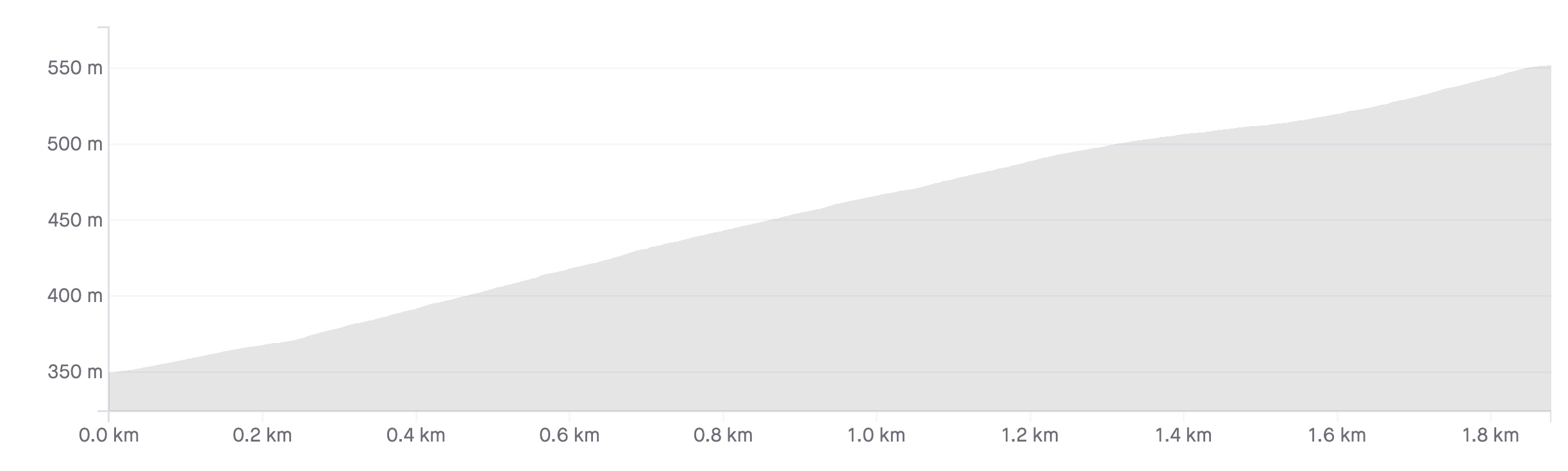
Length: 1.9km
Average gradient: 9.9%
Elevation gain: 188m
Introduction
Located on the north-west outskirts of Ararat in Victoria’s west, the climb up to One Tree Hill is short but very challenging. In a little less than 2km the road climbs nearly 200m — an average gradient of basically 10% — but the views of western Victoria from the top are more than worth the effort.
The start
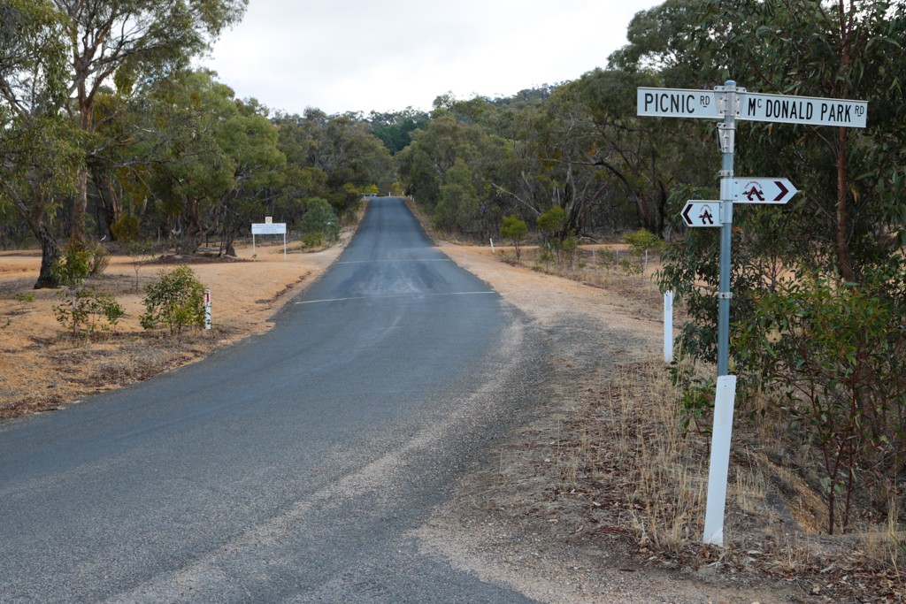
The One Tree Hill climb starts at the intersection of One Tree Hill Road, Picnic Road and McDonald Park Road, roughly 3km north west of the Ararat town centre.
The finish
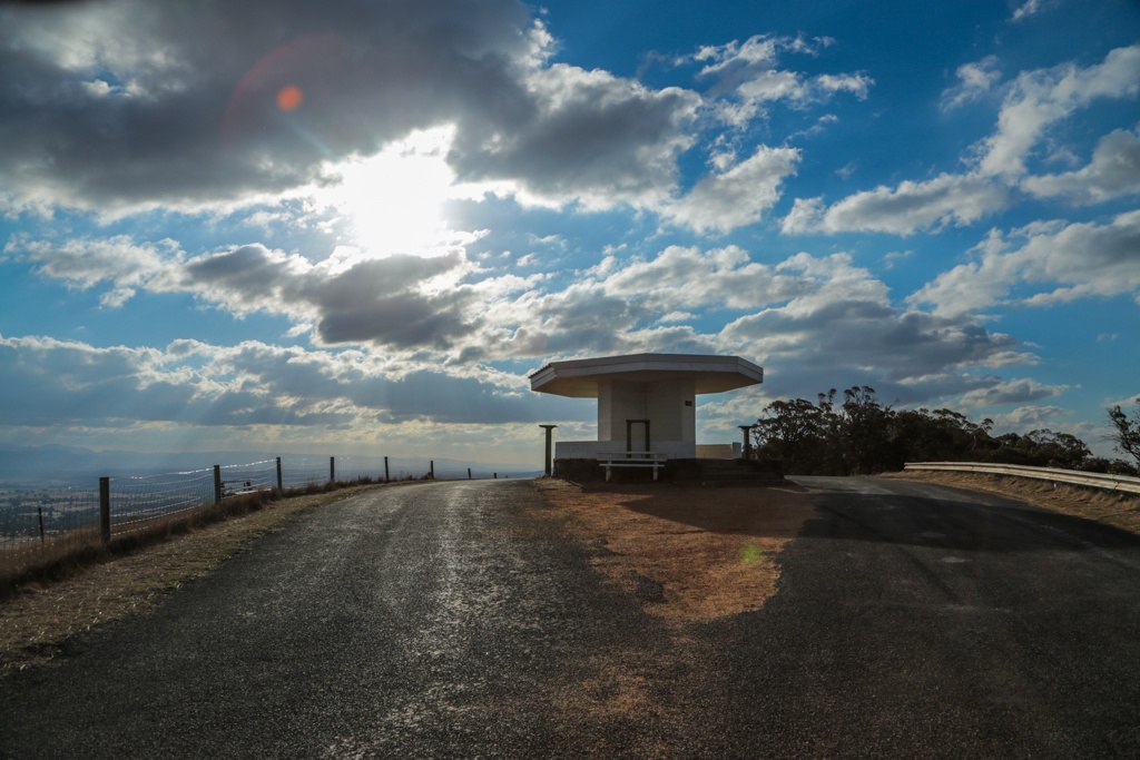
The One Tree Hill climb ends at a rotunda at the summit, just before the road turns to gravel.
At a glance
- A short but very steep climb that barely drops below 10% gradient.
- From 1.3km to 1.6km the road flattens off slightly.
- The final 300m of the climb are the steepest, with gradients approaching 13%.
Climb details
The road starts climbing as soon as you turn onto One Tree Hill Road and within 100m or so the gradient’s already 10% … and it barely drops below that.
You’ll bend slightly to the left after 300m of climbing with the gradient hovering at around 12%. At this point the road ahead is reasonably straight and you can see a communications tower ahead of you to the right.
For the next 400m the gradient stays at around 12% before you swing sharply around to the right after 700m with the gradient at about 10%. The road is quite narrow here (and throughout really) as you approach the summit from the south east.
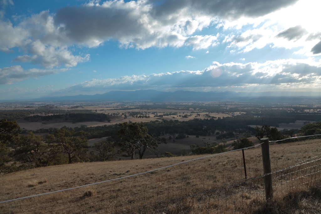
After 900m you’ll bend around to the right again, the gradient still the wrong side of 10%, but at least now you’ve got some great views over to your right to enjoy. As you wind your way gently along the ridge, with a rockface on your left, do your best to enjoy the great views.
After 1.1km of climbing you’ll bend around to your left and see the communications tower directly ahead of you. The great views continue 100m later and after 1.3km you’ll pass the communications tower on your left as the gradient stays at around 10%.
Past the tower the gradient eases off ever so slightly — to about 9% — as you get to the top of the ridge with views possible on either side of the road. At 1.5km you’ll bend around to the right and as the road bends left 100m later the road kicks to about 13% or so for the final push to the summit.
You emerge from the trees after 1.8km of climbing to great views on either side of the road and after a steep final 100m you’ll reach the rotunda at the summit.
Profile
Location
As mentioned, the One Tree Hill climb is located on the north-west outskirts of Ararat, a Victorian town of some 7,000 people, roughly 200km west-north-west of Melbourne. The Western Highway is certainly the most direct route from Melbourne to Ararat and once in Ararat, take Banfield Street and Picnic Street north west out of town to the start of the climb.
If you’re heading to the Grampians National Park from Melbourne, Ararat is one of the final towns along the way before you get there. If you’re near Ararat with your bike and with some time to spare, why not head to the Grampians and check out the amazing climbing on offer there, including the climbs to Reeds Lookout or Boroka Lookout.
Times
The Strava segment for this climb can be found here.
I did this climb in 2016, top ten Strava at the time.
Because of the car hill climbs, the surface has become corrugated, so when you let the brakes off coming back down, it makes you feel like you’re on a bucking Bronco, especially the first bit back down, before the 90 degree left (right if going up of course)!
p.s Sundial climb in the Grampians is one of favorites around there, especially as you can have going down Silverband falls road after, which is one way only….down!
Some time in the early 90’s the Victorian Cycling Federation (now known as Cycling Victoria) hosted a hill climb championship on this road. Run as a time trial with riders set off at intervals it proved more difficult than many considered. I remember at least on rider falling over he was going so slow and more than one rider thinking that the line across the road before the top signified the end. In reality this road has been used by cars in hill climbs and the line is where the driver takes his foot off the gas so as to be able to turn at the top. They get to finish there. We had to keep it going to the rotunda. Remember, this was in the days before compact cranksets. A worthy addition to the site
Great insight Geoff, thanks!