

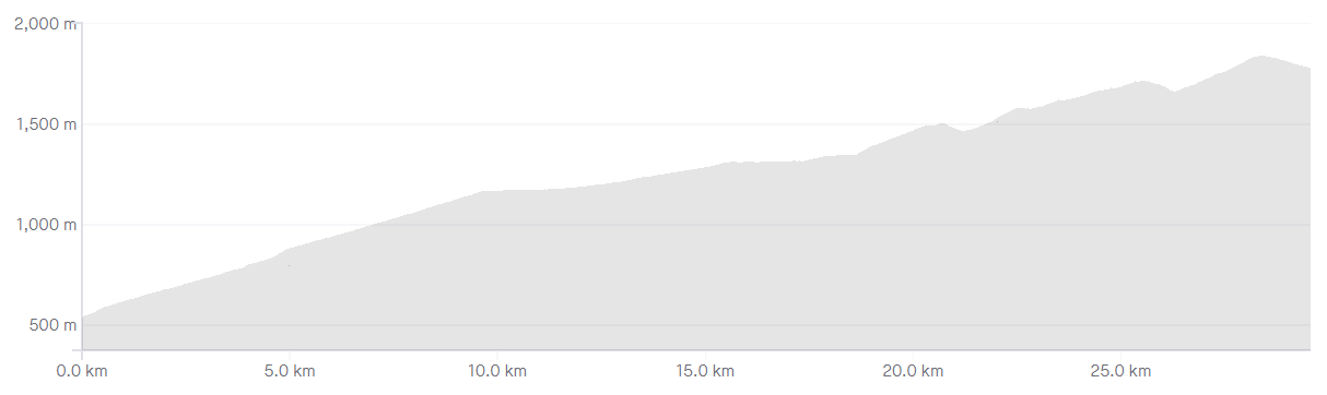
Length: 30.8km
Average gradient: 4.2%
Elevation gain: 1,279m

Introduction
With it’s formidable length and unforgettable moon-like summit, the ascent of Mt. Hotham is among Victoria’s most iconic cycling climbs. Climbing from Harrietville to the Mt. Hotham Alpine Resort, this is a climb in three distinct parts and is a must-climb for every Victorian cyclist.
The start
The Mt. Hotham climb starts at the School Bridge in the alpine village of Harrietville.

The finish
The Mt. Hotham climb concludes at the Hull Skier Bridge, the entrance to the Mt. Hotham Alpine Resort.

At a glance
- A long, challenging climb with three distinct sections, some steep ramps and great views.
- The first section is a steady 11km … except The Meg at the 5.6km mark (300m at ~10%).
- The second section is a long false-flat from 11km to 19.7km with only minimal climbing.
- The final section begins at 19.7km and features two short descents (at 22.9km and 27km) …
- … and: CRB Hill at 23.5km (1.1km at 10%) and Diamantina at 28.3km (1.4km at 9%).
Climb details
While the climbing doesn’t start immediately after the School Bridge, it doesn’t take long for the Great Alpine Road to ramp up. Bending sharply around to the left, the road takes on an initial gradient of around 6-7% which is maintained for several hundred metres. After 800m and a sharp right-hand bend, the road starts to flatten out as lush alpine forest surrounds the road.
2.7km from the School Bridge the road flattens off slightly, before a sweeping right-hand bend 300m later. After a further 300m the road bends around into a sweeping left-hand hairpin before straighening slightly. This first section of the climb is punctuated by a constantly-changing gradient with shorter, steeper sections being balanced out by comparatively easier sections.
4.4km into the climb the road gets noticeably steeper as it bends around sharply to the left. 800m further up the road there is a considerable break in the tree line and breathtaking views are possible to the right-hand side of the road. A further 400m up the road and the breathtaking views are put on hold momentarily as you get to the climb’s first major challenge: The Meg.
As the road bends sharply around to the left, it’s a 400m grind at around 9% before a slight crest brings about the return of a more friendly gradient. For the next few kilometres the road climbs slowly but steadily, twisting into a right-hand hairpin bend at the 8.2km mark. Another 2.8km further up the road – 11km from the start of the climb – the road flattens out dramatically, signalling the start of the climb’s second section – a 9km false-flat.
With the road meandering along at an almost-negligible gradient, terrific views of the summit are available at the 11.7km mark. 1.3km later the gradient increases marginally but not enough to cause significant discomfort. After winding gently for another 2.6km the false-flat turns into a brief downhill before flattening out once more. With the gradient still negligible, the Great Alpine Road meanders gently toward the 19.7km mark and the Buckland Gate.
After a pleasantly pedestrian false-flat section, Mt. Hotham’s final 11km come as a rather rude shock. From the end of the false-flat at the Buckland Gate the road kicks to around 7-8% as it passes a rather accurate sign: ‘Steep Climb – Engage Low Gear’. This steeper grade is maintaned for ar0und 400m before things flatten out to a comparatively pleasant 6%. At the 21.4km mark the road emerges from the tree line and Mt. Hotham’s famous moonscape comes into view.
With the road now clinging to the ridge line, terrific views are possible on both sides of the road for most of the remaining climb. 1.5km after leaving the alpine forest behind, the road flattens out briefly before it plunges toward the valley. After descending sharply for 600m you will come face-to-face with one of the most iconic sections of the Mt. Hotham climb: CRB Hill.
1.1km at 10% might not sound all that challenging but after 22.7km of climbing this stretch makes for a slow and painful grind. CRB Hill ends at Renes Lookout as the road flattens off quite noticeably. 600m later the gradient increases again, with the road cutting through Mt. Hotham’s moon-like terrain.
After 400m of steeper climbing the road flattens out again and a more pedestrian grade is maintained for the next 700m. By this point you are well and truly into crosswind country and the road ramps upward once again, holding its gradient for the next 1.2km.
27km from the start of the climb you will reach Little Baldy Hill where the road drops toward the valley floor once more. After a sharp 600m descent the road heads skyward again, snaking its way majestically along the ridge line for 700m. At the 28.3km mark the going gets a little tougher as you come across another section that is steep enough to warrant its own name: the Diamantina.
At around 9% this 1.4km section is the final challenge and arguably the toughest section of the climb. After a slow grind to the top of the Diamantina the road reaches a crest at the 29.7km mark. By this time all of the hard work is done and you can roll down to the Hull Skier Bridge and the end of the Mt. Hotham climb.
Profile
Location
The Mt. Hotham Alpine Resort is located approximately 350km north east of Melbourne and around 50km south east of the township of Bright. Cyclists coming from Melbourne are best advised to take the Hume Freeway (M31) to Wangaratta before turning east onto the Great Alpine Road (B500).
The Mt. Hotham climb is often attempted from the township of Bright with the 24km ride from Bright to Harrietville acting as a perfect warm-up. While shorter ride options are available, climbing Mt. Hotham without a proper warm-up is not advisable.
Times
If the challenge of conquering this great mountain isn’t enough for you, it’s always possible to time your ascent. A-grade riders in the Tour of Bright will complete the climb in under 80 minutes but anything under two hours is a commendable effort.
To see how your time compares to other riders and to post your best time, head over to the Strava segment for the Mt. Hotham climb.
thank you for making this article very useful and keep up the good work
I tackled this as part of a 2-3 day ride from Wangaratta – Bairnsdale with a bikepacking load. A really stunning ride that lived up to all expectations…thank you for this summary article that inspired me to try it!
Well I tackled this monster last weekend in the 2023 alpine classic, due to falls creek landslides the route was changed to include Hotham.
Note to anyone taking it on for the first time use a compact a 53/39 like I’m running is just brutal.
I found the climb reasonable until the MEG.
After having around 120ish kms and already conquering Mt Buffalo, the meg was a wake up call.
After some time I found a rhythm, the false flat was a welcome change hitting speeds in excess of 30km h.
Then it was over and the real climbing had resumed.
There are a few pinches before the sight of the CRB opened my eyes thinking wow.
Grinding away at around 50 55 cadence.
Cresting at the top to see the ominous diamondtina loomed up before me.
The next 1.4 kms had me reaching to the deepest point of mental strength to continue without stopping for a break.
Throughout the CRB and the Diamondtina strong side to head winds really helped to crush your spirit to test the resilience and fortitude of your mind, this was a grate yard stick to determine if your determination and strength that had developed over the course of your training accounted for anything.
The ski bridge was a welcome sight as I turned the corner.
Coasting down to dinner plains before the rest at the aid station before the return back to Bright.
I am already planning for my next adventure to the cycling Mecca to endure the epic climbs in some of the most beautiful country on this great continent.
Thanks for your site once again.
Reading your articles helps, but nothing truly prepares you for what is to come other than to strap your your cleats and hit the slopes .
Congrats Chelsea, awesome effort! Hotham is a hard enough climb without having 120km including Mt Buffalo in your legs! I’ll be interested to hear how much easier you find it on fresher legs!
Thank you Matt, I’ll let you know if I find the time to get there again fresh.
It’s definitely a must do climb for anyone who enjoys climbing to experience the challenges they present
Just completed this ride and can confirm it is by far the most difficult ride I have ever done. I’ve done Arthurs Seat, all major climbs around Canberra and Mt Buffalo, and this climb far exceeded all of these climbs. The first 10 kms are quite challenging at 6% for the first 5 kms and 7% for the second; ‘The Meg’ is particularly steep and challenging and will surely get you out of the saddle.
The ride gets easier after 10kms up until the 20kms mark where the gradient increases and remains at a nagging, challenging level. The CRB Hill is incredibly hard and the final 3kms really challenged my mental fortitude. Rest assured that completing this climb is a significant achievement and will give you confidence to complete the 7 peak challenge.
Completed Hotham over Easter for the first time. What a beast! The Meg rears up at you with already 700m of vertical – or so – in the legs. The first 10k is complete climbing with very little rest. The second 10km are far easier but still uphill at what seemed to be 2-5%. The new road is pretty rough and seems to take a lot of speed off your tyres making it a touch harder to keep moving.
But nothing prepared me for that final 5km of climbing. Your legs are dead but the hills just get bigger and bigger. Beast of a climb.
Thankfully the last little bit is downhill.
I must say Hotham makes Lake Mountain seem like a mole hill. Don’t think that because you can do a 20km climb that you’ll be good on this one – you may not. Complete and utter pain.
Rode down from Mt Hotham to Harrretville on easter Saturday with 3 other fitter friends, then something came over me & decided to ride back up! Haven’t riden hills like that for a few years, in fact probably BC, BM (before children, before marriage) 25 years ago. Keep pretty fit though normally but there’s nothing like climbing a mountain to sort things out. Had to walk a couple of hundred meters before Rene’s lookout (?) , then also just before Hotham – legs were SPENT, nothing left. Super glad I’ve done it, though. Wouldn’t have thought I could. Had fabulous weather all weekend, sunny & clear, not much wind. Now looking in to doing the 7 Peaks next year. What’s come over me ! 🙂
I did it! I rode down first 1hr, then up 2hr2 mins. I’m super happy cos I don’t get out on my bike much, and never ridden anything this difficult before.
Glorious day. Stunning scenery.
Not gonna lie, it was agony. Thought I was going to die on the final ascent. So, I think, did anyone who saw me! ?
Great description of the climb, it really helps to know what punishment lies ahead.
Note on the new surface, mainly on the top 10km, it’s a bit oily and rough on the descent, so on wet/icy days I would exercise caution.
Rode up Hotham for the first time in over a year doing the 3 Peaks event and I have to agree with ANTO the new road surface is rough, lumpy, bumpy and dead. Hopefully it gets better once it has bedded down and the traffic smooths it down but at the moment the new surface is much slower than the old surface
Unfortunately I had a different experience to Jules. The roadworks up the Harrietville side of Hotham are ongoing though March 2018 and are easily negotiated, however the sections they have resealed are IMO an utter mess for cyclists. Rough, lumpy, gravelly, sharp (I punctured…twice) – not at all bike friendly, particularly the descent. As of 21/2/2018, almost the entire false flat section has been resurfaced with what I can only assume is the finished seal given the bright new alpine orange line markings. Ok, I get that the seal is probably the best outcome for mitigating black ice etc., and that it may take some time to ‘bed-in’, but I have to question whether VicRoads did any consultation with local cycling groups or stakeholders given the importance of Hotham as a cycling destination.
Just FYI they are resurfacing the road on Hotham at the moment. Delays, semi-sealed sections, gravel. It’s still rideable and they are managing the traffic. The new surface is very good.
Thanks for your site, I am reading this looking forward to returning to Hotham soon, thanks for the inspiration
Hi Matt,
I was thinking of riding Harrietville-Mt Hotham return then driving to Dinner Plain and doing Dinner Plain – Omeo return in the one day. I’ve done a fair bit of climbing this year (AGF Gran Fondo, Whittlesea Challenge, etc) but would wouldn’t say I’m a super-strong climber. Do you think this would be achievable or should I just try the one section..
thanks
Mark
Great site and great write up of climb. Its a beast no doubt about it, the final ks are just so tough – particularly with the extreme uv sun beating down on you!
Question for everyone, where to get ‘water’ at Mt Hotham? I used 2 bottles on climb … it would have been good to refill for ride back to Harrietville. Anyone know?
The General Store is normally open and very cyclist friendly
Free chilled water!!!
It’s probably 2kms towards Dinnerplain past the bridge.
Opposite the police station.
Hi Mike,
If you continue on for about a kilometre slightly downhill you’ll get to “The General”, a pub that also has a small shop located inside. I’m not sure what the opening hours are, but so far it’s been open every time I’ve been there.
Road up on Jan 9th 2017. Overcast and muggy on way up arriving at summit just as rain started to set in. This mountain can bite and within a half hour we were descending in torrential stinging rain with visibility on the top down to one snow pole. Arrived in Harrietville hands aching from modulating the brakes all of the way down and shaking from the wind chill but warmed up again returning back to Bright. It’s a rewarding ride but if your not used to how quickly the weather can change in the mountains like you can get caught out like I was.
Shepparton Alpine Club is a ski lodge offering summer accommodation to cyclists doing altitude training. For more info please see our website.
Yes we stayed there at the Shepparton Alpine Club over Easter – was fantastic. Can recommend it.
Rode Mount Hotham on the 17 December 2013 on my 39 year old Peugeot and again last Sunday (2 March) on my Jamis flat bar road bike (26/34 gearing). Both these ascents of Mount Hotham were from Harrietville without a warm up. Last year I climbed Mount Hotham from Harrietville on my Trek Madone 3.1 with 34/30 gearing making three ascent on three different bikes.
I have modified the Peugeot from a the original 10 speed (50/40 chain ring & 14-28 cluster) to a 15 speed with the addition of a 30 tooth “granny gear” chain ring. Although I am 68 this modified gearing has allowed me to climb almost anything without stopping, albiet very slow at times.
Last year I climbed all 7 peaks and so far this year I have climbed the 7 peaks twice with the exception of Dinner Plain and Mount Baw Baw. This year 5 of the 7 peaks have been climbed riding the Peugeot. The centre pull breaks on the Peugeot are not the best for decending compared to the modern canterliver setup, but I have managed to descend each time without mishap.
The worst part of the Mount Hotham climb I have found when there is little or no wind is the flies which can be a real nuisance especially if one happens swallow them.
Bill Viney
Go Bill. Ten years behind you in age, but my first climb of Hotham was on my 1975 Peugot PX10LE about 5 years ago. A mate had got me riding for the first time in over 20 years, and did the Alpine Classic on the bike, steel pack rack and all. After a year or so, it was those brakes on descending that sent me off to buy a new road bike. No better in many ways (do Stronglight chainwheels ever wear out), but stops in half the time.
Matt, superb site. Rode BawBaw with you and Hells 500 last year, and love your work.
Mont Ventoux soon.
I climbed Mt Hotham in the dark on Australia Day as part of the ACE250. I set off from Bright at 4AM with a couple of hundred other riders. I quickly found a bunch that was doing a nice easy speed. Where the road was not obscured by trees or hills, I could see an endless stream of bicycle tail lights stretching out before me.
I reached Harrietville at about 5AM and started climbing. It was pitch black. It wasn’t until I reached the false flat that I could make out faintest detail in the forest. The darkness focused my attention on my riding mates for the day. Conversation flowed easily in the darkness.
We reached the tree line at sunrise. Fog was hanging in the valleys. There was a perfect blue sky above. There was barely a breath of wind. I could not have scripted more perfect riding conditions or more beautiful views.
You don’t need to do the ACE250 to climb Hotham before sunrise. Pick a perfect weather day, get up early and do it. You will remember the experience for ever.
PS. One of my riding mates on the ACE250 was 74 years old. He easily completed the 250km loop. I really hope I’m as fit as him when I’m his age.
Did it yesterday…it was glorious with birdies and mist and stuff.
At 72 I feel proud to have climbed to the top of CRB hill yesterday. Good weather but really cold on the hill and descending at about 3pm. Thanks for your detailed description of the climb, I read it post-hoc, as you can see. Great website!
I did this ride on 27 December 2013. It was absolutely stunning, but hard work. The Diamantina is quite uncalled for after all that climbing in the first 28km. Just looked at the Strava times and my 2 hours doesn’t look too flash in comparison, though I passed a few people on the way and I was happy with it.
The descent wasn’t as terrifying as I thought it would be (being a cowardly descender), but the ride from Harrietville to Brigjht on the way back was a lovely wind down – sitting on 32-33 kph and shaking the stiffness out of the limbs.
Hi, great site and love the reviews of the 3 peaks climbs. Having had the pleasure of riding both Mt Hotham (Fri Nov 15) and Mt Ventoux in France (Sept 23 & 24) I have to say that although challenging, Hotham is nowhere near the difficulty of Ventoux from either Bedoin or Malaucene. Although 30kms long the false flat middle section makes the climb very manageable and allows recovery before tackling the two challenges of CRB and Diamantina. Ventoux from Bedoin has a section of just under 10kms at an average of almost 10% with not a flat ramp to be seen, brutal! Having said that, Hotham is amazing and the true climbing highlight (along with the Mt Beauty side of falls) of Australian cycling, iconic, scenic and massive, a cycling must-do for anyone who loves riding their bike.
Fantastic site!!! Well done and
I’m off to do Hotham this Saturday, Have done it a few times now, but it has been about 2 years since last time, A fantastic climb, planning to start from Haritteville @ around 6am and hopefully a nice sunrise on the way up.
If you are on here researchin and toying with the idea climbing Mt hotham, do it!!! best climb in Aus in my books, you will love it!
Love your site! At 55 and cycling for less than a year, I refer to your site prior to any climb. I commend you Matt for both your accuracy and ability to communicate. Well done!
They reopened the road to Hotham for this Easter weekend. And the road crews have done a great job IMHO fixing it up.
(React to signs you read. The road narrows to a single lane controlled by traffic lights! In one place about a third of the way up. For those riders from Omeo end – beware!)
I had a great time. It took me 3 hours to lug the 20 kilos of my spare tire up this hill. Definitely the toughest I’ve done so far. (Lake Mountain and Buller. Not counting an abortive attempt on Baw Baw!)
Like Chamitha points out, having to “climb” your way down this hill was – for me – the hardest of the tasks. My legs screamed in a world of pain having to be reactivated for a couple of steep sections on the way down.
Also, I could not find a sandwich on the mountain! “We’ve finished lunch” was only response from the staff of the general store. So, take your own supplies for your arrival – unless you positively know you can get a feed.
All the best Matt and readers
I hear you Mike! The last of the “climbs” on the way back finished not a metre too soon. It was just as much a battle of will power as it was physical. The thought of a hot coffee and meat pie kept me pedalling!
This may seem like stating the very obvious but if you plan to ride back to Harrietville after the climb; the roll downs to the Hull Skier Bridge, the Diamantina and the CRB Hill turn into short but sharp climbs. So remember to save up some legs for the return back.
Good point. 🙂
I rode Hotham again last week & it is without doubt a commendable challenge in whatever time. As stated the 24km from Bright is an excellent warmup with an average +1% gradient before the real climbing starts in earnest from Harrietville. I always find a quick coffee and fuel up there an excellent decision before the ascent starts without mercy. Fine mild weather is always ideal for this climb but start early before the heat. The last leg from CRB Hill to the summit is the toughest but doable for any cyclist who has done a little preparation. Great views and the ride down is all part of the reward for your efforts.
I climbed Mt Hotham for the first time on Sunday. The Meg, CRB Hill and Diamantina Hill were nasty, but the rest of the climb was quite manageable. Pick a clear, still day to climb Hotham. The top section is very exposed and would be extremely unpleasant/dangerous in bad weather.
Hey, I’m very familiar with driving the Mount Hotham roads but have not ridden them before.
What is it like to ride it with cars on the road? I’d go in the summer or around autumn/spring, when there is no snow. I have driven those roads a lot before and I noticed it would be difficult/dangerous for a cyclist to attempt to ride it. What was it like for you? Any tips regarding it? I mean, the roads are not really cyclist AND car friendly 😛 Thanks much,
Alexandra
Hey Alexandra. A good question, but I’ve never had any problems up there. I’ve climbed Hotham in summer, spring and autumn and they’ve all been fine. There’s hardly any car traffic up there and what little cars there are give you plenty of room.
Winter would be a different story though. I haven’t climbed it in winter but I imagine the traffic would be considerably heavier. Hope that helps!
Im thinking of doing this climb in July in the middle of the snow season. Will I be allowed to ride up if cars are forced to fit chains and would I even be able to get traction to ride up? I’ll have a friend following me 45mins later in a car for support btw which will be my return ride (icy roads and decent = bad idea).
Hi David, I can’t speak with any authority here but I think you should be fine. They don’t seem to charge entry for cyclists (http://www.mthotham.com.au/travel/entry/) and it’s an open road so I think it should be fine. Just be aware that there will be MUCH more traffic on the road than in summer. Do with that what you will. 🙂
Can be very cold and windy depending on when you do the climb. If the weather is good the descent is fine, if there is wind, you want to have good control of your bike and either way you want brakes that are working well… 🙂
This is a great site. I am a cyclist that does ride around hilly terrains, having ridden lake mountain, buffalo, tawonga etc. never ridden hotham. I am a little frightened of heights. Is hotham an incrediably fats descent. Is it controllable? Would i be absolutely terrified of the open spaces?
Regards
Elisabeth
Hi Elisabeth,
Thanks for your comment. The descent off Hotham isn’t dangerously fast. The first few kilometres of the descent a pretty windy (in both senses of the word) and pretty exposed so I always take it easy down there, but it’s probably no more dangerous than the rest of the descent. It’s certainly controllable so don’t worry about that. As for it being open: it is probably the most exposed climb I’ve done (behind maybe Mt. William in the Grampians) but it’s not scary or dangerous. The views are great and it’s an epic climb. Give it a shot!
Cheers,
Matt
It’s hard to say for certain, but I reckon the road surface on Hotham has progressively deteriorated. I had an off when I hit a bump and got thrown off my line after racing up it at ToB. I put that down to fatigue but went down (hill) again this week and definitely noticed the poor condition.
Also there are 2 corners worth being particularly careful on:
– the start of The Meg, which is a steep RH’er and if you enter too fast, you can’t do much about it.
– the final corner, another RH’er into Harrietville. I don’t really have a problem with this but it seems to consistently catch people out. Poor cyclist being loaded into an ambulance on Sat.
Hotham is brutal but very rewarding. As tough as any of the mythical Tour climbs such as Ventoux .