

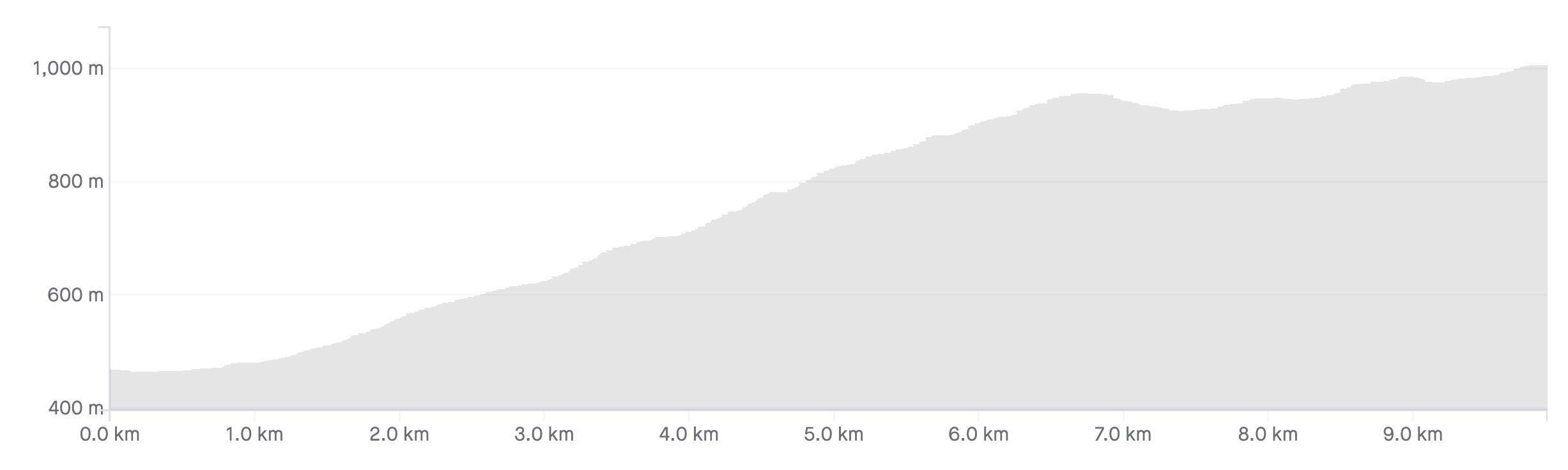
Length: 9.1km
Average gradient: 5.4%
Elevation gain: 491m
 climb.")
Introduction
While the ascent of Mt. Macedon is shorter from the Gisborne side than the Woodend side, it is also far steeper. With several sections maintaining a gradient in excess of 10%, this is not a climb for the faint of heart.
The start
The southern approach to Mt. Macedon begins at the ‘Welcome to Mt. Macedon’ sign, seen on the left-hand side of Mt. Macedon Road (C322) just north of Childers Road.
 climb.")
The finish
As with the Mt. Macedon climb from the Woodend side, this ascent ends at the stone pillars which mark the entrance to the Memorial Cross Reserve.
 climb.")
At a glance
- A tough climb with some very steep ramps in its first half.
- The first steep ramp is from 600m to 1.1km, the second from 1.6km to 2.6km.
- From 3km to 5.5km the road is very steep except for at 3.5km, 4.1km and 4.7km.
- Turn left at 5.5km to continue the climb.
- The final 3.6km after the turn-off are undulating with a steep 500m rise after 7.5km mark.
Climb details
The southern approach to Mt. Macedon begins with the summit clearly visible straight up the road. After climbing gently for around 600m, a sign on the left of the road declares ‘12%, next 2km’. Luckily, the sign isn’t completely accurate and while 12% may well be reached in this 2km stretch, it certainly isn’t the average gradient.
The first 500m after the sign are painfully steep but after that it flattens off slightly for 500m, past Mt. Macedon Primary School on the left. At the 1.6km mark the gradient increases and 400m later it increases again.
By the time 2.6km have been ridden the first of the climb’s tough sections has been completed. Flattening off somewhat, Mt. Macedon Road continues to wind its way gradually upward for the next 400m before another sign – “13%, next 2km”.
Unfortunately this sign is significantly more accurate than the first gradient advisory sign. From the “13%” sign at the 3km mark until the Memorial Cross turn-off at 5.5km, you will find yourself grinding slowly up the steep incline.
Luckily though, this steep stretch is punctuated by several flatter sections – 3.5km, 4.1km and 4.7km into the climb respectively – where brief respite is possible. The last of the flatter sections extends for some 200m before resuming a painful gradient for the 600m to the Memorial Cross turn-off.
At the 5.5km mark, turn left onto Cameron Drive (C328) and push through another 200m of relatively steep climbing. As you crest the hill the hard work is done. The final 3.2km from the Camels Hump to the Memorial Cross undulates quite substantially with several short downhill sections.
The most challenging part of these final kilometres is a fairly-steep stretch that starts at the 7.5km mark and sits at around 8 or 9% for 500m. Compared to the two steep sections in the climb’s first half however, these final kilometres are relatively painless.
Profile
Location
Mt. Macedon is located around 70km north-west of Melbourne and is best accessed via the Calder Freeway (M79). To get to the start of the climb, take the Mount Macedon Road (C322) turn-off which is around 5.5km after the main Gisborne turn-off. The start of the climb is just past Childers Road on the left, 5.0km from the freeway off-ramp.
With the Calder Freeway being open for cycle traffic north of Sunshine Avenue, there is scope for a Melbourne to Mt. Macedon return trip. For those that choose to drive to the base of the climb, the trip is a little less than an hour from the centre of Melbourne.
Times
The Strava segment for this climb can be found here.
Tried the first time a few weeks back rode from Kyneton time not great, bit of a slog at 32mins, went big chain ring (stock standard setup, whatever that is) great descent down back to Kyneton via Calder, but you have to go thru Woodend, no on-ramp, damn!
Thanks Matt for your website.
Yesterday was my third attempt at this beast. 3 years ago I started riding. I am a runner but with my new flash bike and lean body I thought I could ride hills so I took on this as a first challenge. It beat me. I returned 3 years later on a Thursday. Overconfident I blew up again. I was pretty annoyed so the next day, Friday, I had to drive back and try again. This time the plan was go slow, real slow. Use the less steep bits to recover and go slow. Took me 53mins to summit but I did it. Climbing is about patience as I am learning.
Thanks to Tony and Richard for their tips on Alton Rd. I checked it out yesterday starting from the car park on the corner of Honour Ave and Mt Macedon Rd. I headed out on Honour Ave and then turned right onto Waterfall Rd and started the climb. Waterfall Rd becomes Gosvenors Rd, then a quick right then left at the T junction with Dalton Rd onto Alton Rd and finally a short unsealed road, Clyde Track, that takes you out onto the main road, Cameron Drive, which takes you to the Memorial Cross. It sounds more complicated than it is because you just need to point yourself upwards and follow the sealed road which becomes Clyde Track at the end.
This is without doubt the steepest sustained climb I have ever ridden. I rode it on a CX bike with a 40T chain ring and an 11-42 cassette and i needed every gear.
Enjoy
First time up Macedon a few weeks back, although I went up Alton Road. A little bit of mud and moisture on the road in places meant I got a bit of rear wheel spin on the steep sections when I wasn’t careful enough about weight placement.
Great site Matt.
Your detailed insights are really beneficial when tackling a new climb.
Rode a ‘3 peat’ Gisborne side up to the Camel Hump yesterday morning as part of 3 Peaks training; you don’t get many k’s in for the time on the bike, but you do get some good vertical metres!
The descent is fantastic, pretty good road, no/few cars, great corners.
Being close to Melbourne it’s great to alternate weekends between this climb and Mt Donna, for Peaks training.
Thanks for the overview of the climb- was very helpful and details spot on during the climb. – I really enjoyed the climb -.
My decent was via the Woodend side – had to watch out in places for loose gravel and some dry mud clumps- not fun to hit at higher speed! Shadows from trees on the road may make it harder to spot uneven surfaces.
I rode mid morning mid week but in school hols- plenty of “Sunday” drivers with a car full of kids and the family dog slobbering out the window-thanks Rover!! The joys of riding – better than a passing cattle truck I guess.
Testing and enjoyable ride- rewarding views- well worth it.
Thanks for the blurb climbing cyclist.
Did the Climb from Gisborne. Parked at New Gisborne and did a 10km warm up via Barringo Valley before we started the climb. Very tough climb with little respite. Especially where the second sign says 13% next 2km. You just need to grind it out and control your heart rate. Weather was poor with low visibility. Once we reached the top we descended to Woodend and did the climb back. Overall a great ride once we reflected back.
As part of my prep for the DD15 I thought I’d give Mt Macedon a crack yesterday. I parked at Clarkfield, then rode south to the Sunbury Rd intersection then turned north into a screaming headwind. Through Sunbury and Riddells Creek then up the Beast, down the Beast and back to Clarkfield via Romsey. Around 90kms of difficult but incredibly satisfying riding. There are some awesome views to be had on this ride. I was so slow up the climb, a couple of times my Garmin auto paused because it thought I had stopped. This is a really challenging climb.
Love the website and commentary.
Living in the west of Melb this is really the one to do without having to worry about cars or trains to get to the start of. I’ve had a success from the Woodend side (semi easy in comparison) and three attempts at the Gisborne side and only one victory and I rate myself as a reasonable weekend warrior (seem to burn too much on the 50-60km commute to the start). The gradients are significant and pretty relentless and as the author above says – not for the feint of heart, nor might I ad, those of us with 53/25 gearing and carrying more weight than we need.
Some notes:
The climb from Toolern Vale to Gisborne is also not to be sneezed at particularly into a northerly – i.e. don’t burn too much juice here. The servo at Gisborne sells Powerade / Gatorade (steep short mini climb out of Gisborne). The cafe at the top of Macedon doesn’t sell either, only bottles of water and then seeks you to take your empty bottles with you as there are no public bins (there are in the toilet block near by). If you can get into a groove, no matter how slow, then as noted above there is a mini restbite between the 12 and 13% signs and the duration of the pain to the turn off near the top is a little less than advertised. I recommend not looking at Strava times for descent (at least in advance) as the numbers are just crazy. Gradient is such that 80km/h peaks are quite possible, but please, use your brakes and live longer (particularly in the 60 zones). Round trip from Caroline Springs area circa 130ish km and 14-1500m of climbing. Biding my time for another crack.
Happy riding..
This climb was included in the 2014 edition of the 100 km Melbourne Autumn Day Ride (known as the MAD Ride), promoted by the Melbourne Bicycle Touring Club in April each year. It was one very tiring ride, all thanks to this climb appearing just after the start. As per all the other comments, it was tough, with plenty of people walking the steep bits. Make sure you are ready before attempting it!
On a side note, the MAD Ride is a great public event – well organised, plenty of riders, various options and cheap to enter. Google the web site and give it a try next Autumn.
Starting at the car park on the Gisbourne side, heading up to the Memorial Cross, down as far as Boundary Rd on the Woodend side and back over is one of my favourite Sunday rides. I am only a recreational rider and 35km normally takes me 1hr 45 minutes. Most importantly, I am not sure if the egg and bacon roll at the Trading Post café would taste as good if I hadn’t done the ride and I will leave that open for debate. One word of warning would be that if you look up “micro climate” in the illustrated dictionary there is a picture of Mt Macedon. On Saturday 4th January 2013, it was drizzling and the Garmin reading was 3 degrees. All good fun
Matt, this is such a great resource for those of us who get a kick out of climbing. Great site.
I rode Macedon yesterday and loved it. It was a stunning day – 21 deg and clear skies, perfect! I set off from Riddells Creek which gave a good 12-15km warm up before I hit the climb proper. It’s definitely a tough climb, particularly the 13% signed section. But really enjoyed it and the decent through Macedon is fantastic, but need to watch speed going past the pub etc, 😉
Thanks again for such an informative and inspiring website.
Steve
Matt, I saw your videos of your climbs up Alton Rd and Straws Lane on youtube:
http://www.youtube.com/watch?v=td-sFnyFOwo
Nice work, but as with all cameras they just don’t do the gradients any justice.
When do these get a write-up on your site? Could encourage more folk to see these for themselves.
P.S. Several good long unsealed roads to climb up there as well. Some diabolically steep.
Finally I attempted Macedon after wanting to do it for a couple of months. I’m a relative intermediate rider with a handful of rides up the 1in20 and a couple up Arthurs Seat. However I wanted to crack Macedon anyway. Climbed up the Gisborne side three times and Woodend side once. Amazing views in late Spring. It rained & hailed at the top. But an amazing experience. My legs died afterwards!
Did a group ride from Gisborne to Daylesford thru Mt Macedon a week ago. It can get very cold up in the mountain like alps.
from the base up to the Cameron drive turn off is challenging , first 2ks of the descend to Woodend side got few sharp bends .. look for oncoming cars …. then is a nice descend.
BTW the descent back down towards the Macedon township is a cracker, pretty easy to hit 80+.
I always enjoy Macedon, it is a challenging climb with great views, for a trip with a differenc; I find if you catch Vline to Gisborne ride over Macedon and descend to Wooden but turn back at Boundary Road, back over Macedon again and follow the road to Riddles Creek you can pick up the Vline back to Melbourne, http://www.mapmyride.com/routes/view/163116064.
It gives you over 780 metres of climbing and a bit of leg spinning to work the lactic acid out at the end, not many cars either!
Thanks for the site it keeps me Climbing those Hills
Seddon
Had a crack at the Gisborne side early this morning. As accurately described in Matt’s review, this is a very tough grind. Unless you’re a real mountain goat climber, you’ll just be looking to hang on. My speedpo was reading 4-6 km/h in sections.
Having parked at the little info stand/public dunnies at the base, I pretty much headed straight up the mountain after a 1-2km warmup. Somewhat amusingly, the 10 km chime on my Garmin wasn’t reached until the 48 minute mark. That’s never happened before and is testament to the gradient on this climb. At least I managed a wry grin.
I’d recommend doing this climb on a cool morning. You’re going to be in the red zone pretty quick, so adding in high tempreatures would make it very difficult.
The climb descent over to woodend and climb back is a nice way to recover your legs and continue getting the ks in them for whatever event you’re training for (me – the Alpine Classic).
Not sure what it’s like to climb during the day, but early morning there wasn’t a soul around. I was passed by 1 car on the way up, and saw a total of 4 cylcists out and about this morning.
Matt, thanks s much for this site, it’s truly and inspiration. We climbed the Woodend side and Gisborne side on Saturday morning. The write-up was great in helping me mentally plan for the climb. As you eluded to, the Woodend side is a breeze, the Gisborne side has some very steep gradients, my Garmin showed 14% at times. The whole time I kept thinking, “this isn’t so bad, just think of what the 3 Peaks riders are going to experience tomorrow”. So thanks again, tomorrow we’re off to Donna Buang, I’m going to be on my CX bike which will give a very nice and cruisy gearing option (36/46 – 12/25). The CX bike will also make quick work of the Warby trail and the Don Rd descent. The 3 Peaks is over now, well done!
Hi, love the website. I use Mt Macedon as my 3 peaks training mountain. Starting in Gisborne I ride straws lane side from behind Hanging Rock twice, and the Gisborne side twice, cutting through Woodend twice. Awesome ride, over 2.4 vertical climbing metres, over 130km. Second time up Gisborne side is mental torture but rewarding. Great place to train.
1st time up macedon this morning – rewarding climb up the gisborne side…agree that first section @12% was optimistic, but 2+3 sections were tough! Nice decent into Woodend too. Absolutely loved this ride – will be back again soon.
Hi Vass. thanks for your comment. ‘Tis a great climb. Did you do the other side as well? Well worth the effort!
Just got back from a trip to Macedon, a great spot alright. Both the main climbs are great – Woodend side isn’t too steep and lets you appreciate the views and lack of traffic, Gisbourne side is a real tough climb. Also went up Alton road – it’s a bit of a gem alright, the first k or so is not so steep with cool little hairpin bends, but after that it gets really really steep, made it to the gravel (which looked in ok condition) and turned back. Also tried the ride up from the hanging rock side – straw’s lane I think – intersection with Romsey – Woodend road, which gives another nice option – its a little under 5k @7% to the camel’s hump.
Macedon Rangers is such an awsom place for training, south side of the Mt is a very tough but rewarding climb, watch out for the roos when descending into woodend though, have had quite a few close calls.
Its great that now even more of Alton road has been sealed legs sure do feel it when the grade kicks up to the mid 20%, amazing views on clear day but find it more enjoyable when the weathers against you
Whats the elevation of Alton rd? I thought the climb was awesome
I took Alton Rd road early one morning back In Dec, for the first time. Wow, its picturesque, quite and steep, with some nice corners. It was misty (Low Cloud?) and was very eary… It gets very narrow at the top. I turned when I hit the dirt and came back down, the front rim was almost to hot to touch at the bottom… and I was using the back brake as much as possible to avoid overheating the front.
Thanks for the site info. Love cycling and love climbing although not a light weight I still enjoy the challenge.
Next time at Mt Macedon. Try Alton Road. This is one that the locals will use and tourist use the main roads up. (Not that I’m from there).
The grade’s go from 10% and end at the top of the climb at leg / lung bursting 25% (at least thats what my Garmin was telling me). Fortunately that 25% is only for 100 meters. After that try to recover and hit the gravel road for about 4km. Then hop on to cameron drive and then finish it off to the cross. Just something different as once you’ve done the main road a few times, this is a great alternative. Looks impressive on Map my ride lots of purple (20%+)
Hi Tony. Thanks for that tip. I’ll be sure to check it out when I head up there next! Glad you are getting some use out of the site too – good to hear! 🙂