

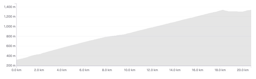
Length: 20.9km
Average gradient: 4.8%
Elevation gain: 1,013m

Introduction
The stunning ascent of Mt. Buffalo in Victoria’s north-east is among the easiest of the Victorian Alps climbs. But, at a touch under 21km, the climb still demands strength and fitness of riders who are keen to partake in the breathtaking summit views.
The start
The ascent of Mt. Buffalo begins at the Mt. Buffalo National Park tollbooth, located around 6km from the intersection of the Mt. Buffalo Road (C535) and the Great Alpine Road (B500).

The finish
The ascent of Mt. Buffalo ends at the now-closed Mt. Buffalo Chalet, marked by the entrance to the Gorge Day Car Park.

At a glance
- A steady, consistent climb with some stunning views throughout.
- There’s a false-flat 7.6km into the climb that lasts for the best part of 2km.
- After 18.4km the road reaches a crest and you’ll descend onto the Mt. Buffalo plateau.
- After 19.1km turn left to go to the Mt. Buffalo Chateau (1.8km), or right to Dingo Dell (4km).
Climb details
The Mt. Buffalo climb begins the moment you pass the tollbooth, albeit with a rather pedestrian gradient of around 5%. 900m into the climb the gradient increases slightly for several hundred metres before flattening out somewhat.
If you are looking forward to fantastic scenery and amazing views, you needn’t wait long: the fun begins as early as the 1.5km mark with ‘The Gorge’ on the right-hand side of the road. 500m later, at the Eurobin Creek, the road turns through a sharp right-hand hairpin before kicking up quite sharply. A more moderate gradient returns 400m later and, for the most part, the road climbs quite gently for the next couple kilometres.
The ascent of Mt. Buffalo is amazingly picturesque for most of the time not least of all due to a series of hairpin bends that cling to the mountain’s ridge line. One such hairpin comes at the 4.5km mark as the road bends sharply, and at an increased gradient, around to the right. One kilometre later the road bends sharply and very steeply around to the left.
After 6.2km you’ll face another steep and very tight left-hand hairpin after which the road continues to follow the ridge line with breathtaking views possible to the right of the road.
After another steep left-hand hairpin and around 7.6km of climbing the road flattens out considerably into a ‘false flat’. Remaining almost flat for the best part of 2km the road snakes its way through lush eucalyptus forest and a thick covering of native ferns.
By the time the road is climbing again, 9.8km from the tollbooth, the valley views are now possible on the left-hand side of the road. At the 10km mark you’ll pass ‘The Font’ and an amazing rock face on the left of the road.
The hairpins return 300m later with a sharp left-hand bend and then, at the 11km mark, a tight right-hand bend that takes you to Mackeys Lookout. With stunning views of the valley below this is a great place for a brief rest should you feel the need.
From Mackeys Lookout the road flattens out a fraction and remains that way for the rest of the climb. As the road bends left at the 11.9km mark a change in the vegetation becomes apparent with dead-looking snow gums visible ahead.
At the 14.8km mark, after several kilometres of fairly gradual climbing, the snow gums that were previously visible are now on both sides of the road. 700m later, at McKinnons Corner, a very sharp left-hand hairpin, another notable change occurs with the road becoming tighter and windier than the previous 15.5km. The road also leaves the ridge line as it winds around a series of hairpins like the tight right-hand bend at the 17.8km mark.
After 18.4km of climbing your efforts will be rewarded with a downhill section 700m in length. After descending onto the Mt. Buffalo plateau take a left-hand turn and climb the last couple kilometres to the Mt. Buffalo Chalet.
Of the 1800m from the turn-off, the first half is flat before the road climbs again, winding through a series of tight hairpin bends. The climb ends at the Mt. Buffalo Chalet, 20.9km from the tollbooth.
Profile
Location
Mt. Buffalo is located roughly 350km north-east of Melbourne and 35km west of the nearest regional centre, Bright. If you are driving to the high country from Melbourne you can expect a four hour drive with the best option being to take the Hume Freeway (M31) to Wangaratta and then the Great Alpine Road (B500) toward Bright.
Accommodation of various sorts is available in many of the nearby towns including Bright, Porepunkah, Freeburgh, Germantown and Wandiligong.
The ascent of Mt. Buffalo can be attempted from Bright for a 70km return trip or, for a more serious day’s climbing, nearby climbs like the Tawonga Gap can be added.
Times
The Strava segment for the Mt. Buffalo climb can be found here.
Hi Matt – FYI your JPG and google maps linked aren’t loading.
are google making you pay for maps now?
I had a weekend cycling around Beechworth and took in Buffalo. It’s a great climb – steady but not egregious gradients although the Garmin did hit 10% a couple of times and 13% once. These were just small pinches though. Views were stunning and I was lucky with the weather, warm but plenty of cloud cover.
Buffalo was surprising hard, I have done it before and did not give it the mental respect it required. I had enjoyed Hotham the day before and was looking for a relaxing climb, I found it a tough,
Give it the respect and enjoy it all
I rode Buffalo on Wednesday after riding Dinner Plain on Tuesday, and the views on both rides were amazing.
These were the last two fine days before the weather changed to winter.
I stopped a few time to take photos but rode continuously from the 11k mark (Mackey Lockout) to the Chalet.
Thanks for your web site Matt. Reading though it with a mate challenged us to have a crack at a few of these bigger climbs. I’m not a bad climber for an old bloke with average fitness but I’d never climbed anything bigger than Lavers Hill on the GVBR. Your descriptions are fantastic and help gauge whether I’m up to it.
On this quiet brisk morning in porepunkah off I headed, giving me a rolling 5km warm up and leading me into the start of the climb. 5km in at the park entrance as expected, the gradient tilted up and up I went. As I ascended my legs quickly remembered the previous 3 days of solid mountain biking I had undergone competing in the bright national champs.
Onwards I continued taking it fairly easy, spinning my way through the lower sections, slowly gaining elevation as I went.
Being a fairly cool day, the game I ended up playing as I went was a balance of adding just enough effort to keep warm vs recovering. This pretty much preoccupied me for most of the climb along with the spectical of watching the many cyclists decending as I climbed. They must have started pretty early I thought.
Still struggling to warm up, on I climbed and before I new it I found my self topping out, decending onto the plateu landing me pretty quickly at the turn to the chalet, the first mile stone was met.
Not content to Finnish at the chalet, onwards I went towards my pre determined goal of the saddle.Up past Dingos I rode, this was where it realy started to get cold and it was where I began to feel the effects of limited oxygen from the altitude (somthing not so noticeable on Buller). Not to much further and their I was at the saddle my goal, I rested for a little then rugged up to start the decent to Dingo’s.
Now Dingo’s is perfectly placed for a quick coffee & muffin, to warm the body before the real decent, a stop in I fully recommend. The lovely lady at the Cafe even gave me the local news to put under my jersey for extra wind protection, I gladly accepted and was off.
The decent is fun, not to quick, but you still Need to check your speed coming into the corners also keeping a keen eye out for rough patches of Rd & wild life.
One last super fantastic burrito at the Rail Trail Cafe in porepunkah and onwards over the pass towards falls Creek I went.
I also second the comment made above about finishing the climb at the Horn. From the Chalet there’s still a couple of hundred metres in altitude to gain on what is far and away the best bit of the Buffalo Road. If on reading this post cyclists feel that by reaching the Chalet they’re done for the day and have seen it all then really they’re missing out.
From the Chalet it’s only a short flat section to Lake Catani before it keeps climbing all the way to the Cathedral, then it’s only another 1km+ until the end of the sealed road at the Horn. The road is lovely, the views are spectacular, and the descent back down to Lake Catani is superb.
Rode up Mt Buff last Tuesday, nice day for it, warm and calm and the climb on a perfectly surfaced road was kids play even for this 75 year old. Scenery was great, but a cafe at the top would have been a real bonus. Climbed many passes in Europe and every one of them offers refreshments. It certainly draws the crowds.
Since 2014, I have ridden up twice more, 2015 and 2016, loved it each time and my times are getting faster too despite me getting older.
Dingo Dell Cafe at Mt Buffalo is open every day over January from 10am-5pm then out of holiday times is closed on Monday and Tuesday. Very cyclist friendly with bike racks and plenty of room to relax in comfort with a great coffee and some reasonably priced food.
The greatest cycling event in Australia, the Audax Alpine Classic week at end Jan 2014, will have a range of the 200km riders leave Bright at 4am to climb The Buff before going onto Tawonga, Falls and back over Tawonga for the Classic 200km. The 4am ascent should be stunning and the sunrise descent a delight. As usual, lots of other events, all non-race recreational, but challenging none the less!
This was my first Alpine Climb, I loved it! The views were great and the climb was as you described it many thanks for inspiring me to take the first steps in training for this climb, I am now going on to my next challenge any ideas for the next one?
Thanks once again for a great site
No, I was too focused on doing the climb from Bright 3 times in the day and missed the photo opportunities…
On the Audax Alpine Classic yesterday they had to alter the route due to the bushfires, and the ACE 250 riders went another 6km past Dingo Dell to Cresta Valley, which adds another ~160m of climbing (and ~5km distance) compared to the route that stops at the Chalet. It was the first time I’ve done it, and it was certainly worth the effort with some beautiful views at Cresta Valley.
Did you get any photos Tim?
I climbed Mt Buffalo for the first time on Monday. The scenery was stunning, the climb was great exercise and the descent was massive fun. Buffalo is heaps easier that Hotham or Baw Baw because it doesn’t have any nasty steep pinches. I reckon I saw two cars on the ascent and one on the descent. The amount of traffic probably goes up on the weekend and during school holidays.
8 hours there and back for me including walking across to the West Peak above Mt Beauty. It’s a 1400 m climb, so quite hard. It seemed to stretch slightly different calf muscles on me.
I find your website very interesting, Matt. All my life I have been a cycle tourer (with panniers), usually in France, but after moving to NE Victoria I have been cycling up some of the local climbs, Buffalo being my favourite. But your website encouraged me at 63 at long last to get a road bike this spring. Falls Creek and Hotham have been wonderful in recent days. Lake Mountain is next but not until my muscles recover from walking up Mt Bogong yesterday – now that makes cycling feel easy.
Thanks very much Richard. 🙂 All the very best with Lake Mountain! Oh, and what’s Mt Bogong like (apart from long and hard)? How long does it take to hike it?
TOo easy.
The Alpine Classic is including the extra kilometres to Dingo Dell. I think this is now a preferred end to the ride over the Chalet site.
There is a visitor center there with cafe and toilet facilities, although I can’t speak for the opening hours.
Why stop there? Surely the finish of any climb is the top – where you can’t climb any more. On Buffalo that is the Horn – not the Chalet. The dirt road at the end isn’t too bad, and the view from the little car park and lookout is superb!
This is one of my Favourite climbs. Due to good ride length some challenging sections and awesome views. Its nice to Big Dog it through the false Flat too. Always take two bottles up this climb no matter what the weather due to time on the bike(maybe thats just the pace I go anyway) .
Hey, for a really nice ride instead of turning off Mt Buffalo Rd just keep riding up past Lake Catani – we stopped in at the kiosk/shop just past the lake. The lake provides an awesome backdrop and it’s a fast sweeping bit of road. Another great ride report and of one of my favourite climbs – did this one twice in the week before the ACE.
Russ.