

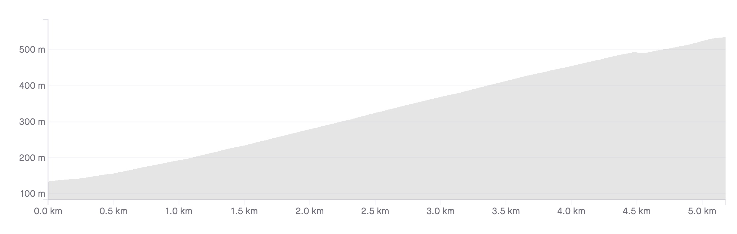
Length: 5.5km
Average gradient: 6.9%
Elevation gain: 377m
Introduction
Climbing from the start of the Mt. Dandenong Tourist Road in Upper Ferntree Gully, the Devil’s Elbows is a relatively short, but deceptively steep climb. Also known as the Devil’s Broken Clavicle, this climb takes in two sharp hairpins as it snakes its way through the Dandenong Ranges National Park.
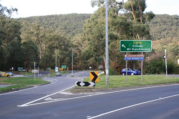
The start
The Devil’s Elbows climb begins at the intersection of Burwood Highway (C412) and the Mt. Dandenong Tourist Road (C415) in Upper Ferntree Gully.
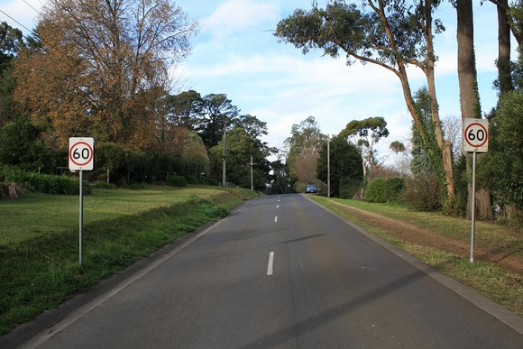
The finish
The Devil’s Elbows climb concludes at the highest point on One Tree Hill Road. This crest comes about 100m after the 60km/h signs and is designated by a fire hydrant on the left-hand side of the road.
At a glance
- A challenging and deceptively steep climb with a picturesque second half.
- The first of the devil’s elbows — a left-hand hairpin at 1.4km — has a gradient of roughly 10%.
- Turn left onto Churchill Drive at 2.6km to continue the climb.
- The second devil’s elbow is a sharp right turn onto One Tree Hill Road at the 4.1km mark.
- There are several flatter sections in the final 1.4km of the climb.
Climb details
From the get-go the gradient sits at around 7% as the Mt. Dandenong Tourist Road winds into the national park. 500m into the climb the road bends sharply around to the right before curling back around to the left. The gradient remains at around 7% through these bends and continues until the first of the devil’s elbows, 1.4km into the climb.
The hairpin bend curls tightly around to the left with the gradient increasing noticeably as the road emerges from the corner. As the road continues further into the national park, the gradient sits at a painful 10% in what is probably the most challenging part of the climb. At the 2.2km mark the road flattens off somewhat, bending into a long, sweeping right-hand bend.
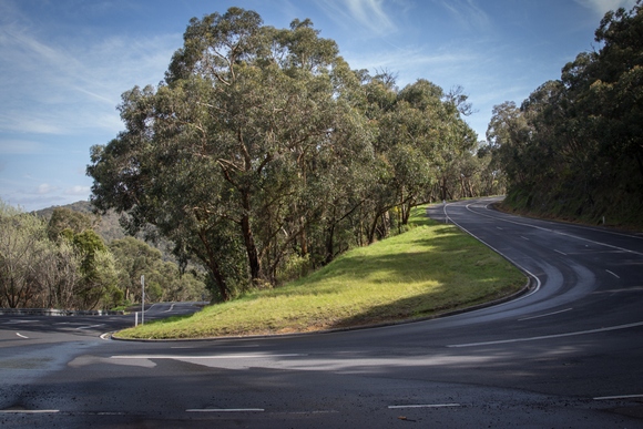
As the road straightens out, 2.6km into the climb, you’ll reach Churchill Drive — take a left turn. At this point the road becomes much narrower and considerably more scenic.
Rising at about 7-8% this is the most picturesque section of the climb with native ferns crowding the road side. As the road winds its way beautifully into the Dandenong Ranges National Park the gradient stays fairly constant at around 7-8%. It isn’t until the 3.7km mark that the gradient decreases a little before the road reaches a slight crest 200m later.
From this point the road descends slightly before reaching the edge of the national park and the second of the devil’s elbows. At this T-intersection, 4.1km into the ride, you should turn right onto One Tree Hill Road and begin the final section of the climb.
Having left the sharp corner behind, the road resumes a gradient of 6-7% for the next 500m before reaching a slight crest again. After 300m with an essentially neglible gradient, the road begins to rise again at the 4.9km mark.
Unlike most climbs, the Devil’s Elbows doesn’t have a clearly visible end point and so you need to be vigilant if you are timing yourself up here. Having passed Merimbula Road on the left-hand side of the road, you will then pass a pair of 60km/h signs. The highest point of the road, and the end of the climb, is about 100m beyond these signs, designated by a fire hydrant on the left-hand side of the road.
Profile
Location
The Devil’s Elbows climb begins in the suburb of Upper Ferntree Gully, around 50km east of Melbourne’s CBD. For cyclists that are coming from the city, the best approach is probably via Maroondah Highway, Boronia Road, Dorset Road and then Burwood Highway.
For a longer and more challenging ride, climb the Mt. Dandenong Tourist Road from Montrose first, following the road all the way to Upper Ferntree Gully before heading back up into the Devil’s Elbows climb.
Times
A Strava segment for this climb can be found here.
Just did this climb, i found it the hardest of the main 4, great scenery on Churchill drive that can get your mind of the pain you’re feeling. I found the first 3kms difficult but i got up there in one piece.
I stumbled onto this website a couple of weeks ago and i’m now addicted to climbing! Been cycling for 2 years now (I’m 36) but mostly just the trails, had no idea about these climbs in the Dandenongs, i started off about a month ago doing about 2 per ride and just did the crucifix.
The devil’s elbow i found the toughest to climb, it hits you straightaway and i find there is no let up until you turn onto one tree hill road. Great climb and great scenery, previous posters are correct about the traffic, there’s more traffic on the road due to it being close to 1000 steps.
The climbing through Churchill road is magnificent.
Just completed this climb, a sunset run to avoid the rush hour traffic. I have lived off Devil’s Elbow since 1991, and this bend has been the site of numerous accidents and deaths.
I’m in training for doing the 7 Peaks challenge, and wanted to know if I could keep going with no stops up a 7% gradient. A bit more training required, but I thought 43 minutes for a 58yr old is not too bad.
Attacked this climb today. Little bit of a mistake as it was my first climb after a 4 month break from cycling. I thought it would be like the 1 in 20 but found it quite a bit more difficult and had to pull over 3 times. Great ride however and feels good to be back on the bike.
Had a go of this climb today. Well worth the 6am start. Quiet, scenic, challenging and way better than the 1 in 20 and far less cyclists clogging the road! It’s my new favourite in the Dandenongs.
Have you ever considered about including a little bit more than just your articles?
I mean, what you say is fundamental and everything.
But think about if you added some great images or video clips to give your posts more, “pop”!
Your content is excellent but with images and video clips,
this website could definitely be one of the very best
in its field. Awesome blog!
I set off today at 6:30 am from my home in Mooroolbark and climbed over Mount Dandenong to the 1000 steps and back. Along the way, I took in The Wall at Olinda, Perrins Creek Road, Sassafras Creek Road, Sherbrook Road (not one of your listed climbs), and The Devils Elbows. The total distance was 98.8km and the time was 5:24. In two weeks time I plan to include the 1 in 20.
I’m training for the Round The Bay on Oct 19, which I hope to do in under 8 hours.
What do you think – consdering the RTB is pretty flat.
Do you reckon this ride is steeper than montrose to kalorama?
Yep, definitely.
i did this one today, but instead of starting at the steps i went up toward belgrave and up hughes rd,. if you’re looking for a bit more of a challenge it’s worth a try.
hughes rd is just before the 7/11 heading toward belgrave, turn left and it crosses over mt dandenong tourist rd and turns into churchill rd, which is the top half of the devils elbow.
I would not recommend riding up the Burwood Highway from the hairpin at the 1000 steps to Upwey, it’s called the mad mile by locals for a reason. The road is busy, fast and there is not a lot of space at the side to hide if it gets tricky. Ride up Old Belgrave Road instead (I think there is a cycle track that runs up that direction) which is used by local traffic and brings you out 50m from the bottom of Hughes Road.
Take care coming back down , especially on weekends!
The traffic can be a nightmare around “the thousand steps”(Dandenong Ranges National Park).
I’m typing one handed,as I narrowly missed a car and now have a fractured clavicle and multiple fractures in my wrist!!!
The 2nd elbow is actually a crossroads, and I couldn’t see a sign for One Tree Hill, so I briefly started up the eastward road, before noticing the ‘no through road’ sign and the other cyclists turning to the right.
hi, i just have a question.
i attempted this today, but missed the turn off at churchill rd, just wondering, how much more difficult it is that way insead of following mt dandenong tourist rd to sassafrass?
i ended up going all the way to sky high, so was happy with the ride in the end..
I went up it this morning for the first time in years. It had me looking for gears I did not have, I also forgot how beautiful it was after you turn onto Churchill Drive.
This is a great climb and super hard (well, for me anyway) if you make it the last of the 3 sides.
is the section of the burwood hwy flat? or have traffic lights?
Matt,
A useful guide for this climb – proved very helpful for my first assault on it yesterday.
People unfamiliar with these roads should note the Ampol service station at Churchill Drive has closed down (as at mid-November 2011 – maybe this is temporary?), but the turn-off should still be fairly obvious.
Thanks Cam – good to know.
The servo is still closed however the building is still there
The servo is now open again.
Hi Matt & Sean,
I reckon you guys are just reading the map wrong, try zooming-in. I don’t know how familiar you are with the area but I was cabdriver for years before I took up cycling and I’ve driven up there thousands of times.
You do indeed proceed for the first kilometre or so along the Burwood Hwy, past Upper Ferntree Gully Railway Station on your left and then the Fire Station on your right. Then, after passing under the railway viaduct the Burwood Hwy hooks sharply back to the right, almost 180 degrees, while the Mt Dandenong Tourist veers off very slightly to the left – one might easily think that they were actually continuing straight ahead.
But, this is exactly what the map clearly shows, so I really can’t understand what you;re confused about. And BTW the in another life many years ago, as a young man I was a navigators assistant in the Navy – so I know my maps/charts.
Keep pedalling,
Denis.
Hi Denis,
Thanks for your email, but Sean was right. When he left his comment the map was wrong and needed fixing. As you can see from my comment I then went in and corrected the error. It’s now correct, as you point out.
Cheers,
Matt
Hi Matt,
I think the map on this one is wrong? Don’t think you go along Burwood highway for the first k?!
Yeah, that’s weird Sean. I don’t know why it has done that. Thanks for picking that up – it’s fixed now.