

Length: 11.5km
Average gradient: 7.1%
Elevation gain: 811m
Introduction
The climb to the highest point in the Grampians National Park is one of the most rewarding ascents in the entire state, but it’s also among the most challenging. The first section of the climb might be easy enough but the final stretch to the summit is brutally steep on a narrow track that’s lashed by strong winds.
The start
The Mt. William climb starts at the intersection of Mt. William Road and Grampians Road (C216), roughly 13km south of Halls Gap.
The finish
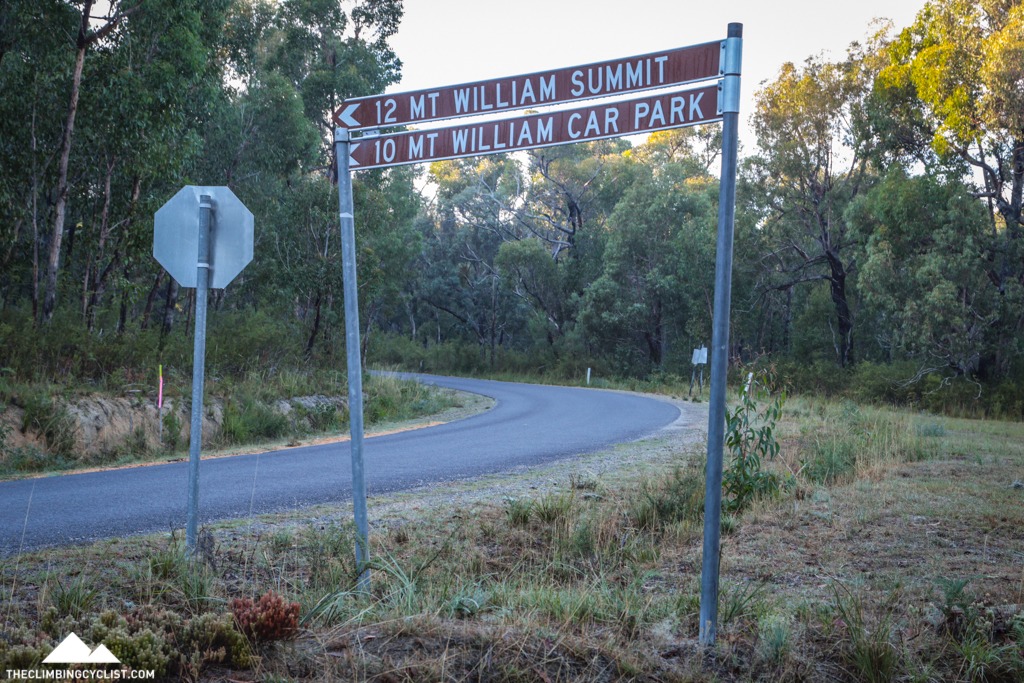
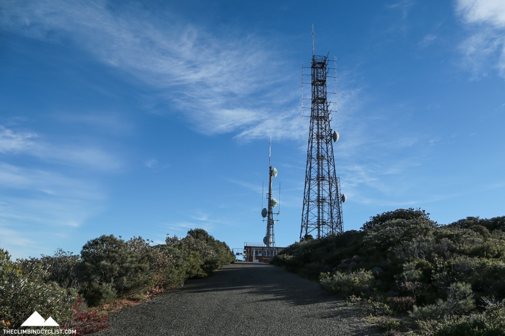
The full Mt. William climb ends at the communications station at the summit. An alternative is to climb only as far as the carpark, thereby skipping the steep final 1.9km to the summit.
At a glance
- A climb in two parts, with a consistent opening section and a very tough final section.
- There’s a false-flat from the 5.7km mark to the 6.9km mark.
- The first section is 9.6km long, averages 6.4% and ends at the carpark.
- The final 1.9km after the carpark rises at an average of 10.8%.
- The steepest section is a sharp left-hander at 10.1km which reaches a maximum of 29%.
Climb details
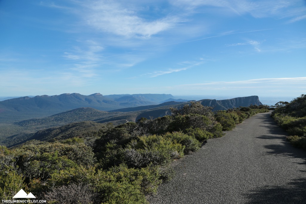
The gradient settles in at around 5-6% as you leave the main road behind and within a kilometre of the start you’re already starting to get a taste of the amazing views to come as the tree cover opens up slightly to the right.
The gradient is consistent in these opening kilometres, fluctuating only briefly as you kick out of corners, or in brief flatter sections. There’s a flat section after 1.7km and a brief increase in the gradient (to about 8-9%) as the road bends around to the right after 1.9km. And then when the road heads back around to the left after 2.0km the gradient kicks to 8-9% before settling back in to around 6%.
As you wind gently up the hill you’ll catch glimpses of the great views on the right of the road, and these only get better as you get higher up. After a series of bends, the road curls left after 3.5km, leaving the views behind for the moment. For the next few kilometres, the gradient fluctuates as the roads winds gently up the hill.
After 5km of climbing the tree cover thins right out and the impressive views return. And 100m later you’ll catch your first glimpse of the communications station at the very top of Mt. William.
After a series of turns and slight gradient changes, you’ll bend around to the right after 5.7km at which point the road flattens off quite noticeably. This false-flat section runs through to the 6.9km mark in which time you’ll pass through a right-hand switchback, you’ll enjoy the best views of the climb so far and you’ll get another look at the comms station at the summit. It’s at this point that you’ll see, for the first time, just how steep the final section of climbing to the summit actually is.
With the false-flat finished after 6.9km of climbing you’ll get start to realise just how narrow and exposed the road is. The road clings to the ridgeline with little protection for wayward vehicles, but the views are exceptional.
After 7km you’ll see the comms station dead ahead once more and you’ll likely get the feeling that you’ve made little vertical progress at all — it still seems so far away.
A tight left-hand bend after 7.9km kicks the gradient up to about 10% briefly, while also opening up some great views on the left-hand side of the road. They don’t last long though and nor does the increased gradient, as the road flattens back to a more familiar 6-7%.
After several kilometres of consistent climbing you’ll bend right at 9.5km into the Mt. William Carpark. This is the top of the open road — to continue to the summit you’ll need to pass around the gate at the far end of the carpark and start making your way up the narrow access track.
This final 1.9km section of the climb is extremely steep in places and has an average gradient in excess of 10%. It is considerably harder than the climb thus far so if you decide to continue on to the summit, be prepared for some tough climbing.
Just before the gate the gradient starts ramping right up and it only continues to do so once you head around the gate and follow the road around to the left. As the road straightens out, after 9.8km, the gradient gradually starts to increase from around 10% to above 20% a few hundred metres later.
There’s a sharp left-hand bend after 10.1km and the final 100m before that bend averages close to 20%. And the steepest part of the left-hand bend has a maximum gradient just short of 30%. It’s painfully steep and extremely challenging, even if you’re using a compact chain ring.
Around the corner the gradient eases to around 15% which feels quite easy after the exertions of the previous section. And after 10.2km, the road bends sharply around to the right, the gradient sitting at around 14% in the process.
At 10.3km you bend around to the left as the views return after a few-hundred-metre hiatus. What follows is a nice straight section of climbing with the gradient hovering around 10% before a sharp, right-hand hairpin after 10.6km of climbing. At this point the views really open up and you get a full 180º panorama to take in.
You’ll actually get a chance to appreciate the views at this point because, for the first time since leaving the carpark, the gradient drops below 10%. The respite is short-lived however, with the gradient increasing to beyond 10% again just 100m later, as the road sweeps around to the left.
As the road straightens out the communications station is visible directly ahead of you. It might still seem like it’s a long way away, but in reality you’ve only got 800m to go.
At the 11km mark the road kinks around to the right slightly, the gradient still above 10%, and as you approach the final corner the gradient increases to roughly 13%.
At the 11.4km mark you bend left, the gradient hovering painfully above 10% in the final push to the summit. And then the road flattens off ever so briefly as you approach the fenced-off communications station which marks the summit of Mt. William.
Profile
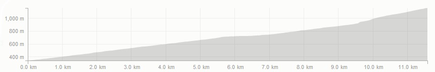
This profile was created using Strava Routes.
Location
Mt. William is located in the Grampians National Park, roughly 270km north west of Melbourne. The start of the climb is located 13km south of the town of Halls Gap, the biggest town in the region.
Visitors coming to the Grampians via Melbourne should take the Western Highway past Ballarat to Ararat. From there, it’s a choice of the road through Moyston and Pomonal (Ararat-Halls Gap Road) or the Western Highway through to Stawell before taking the Grampians Road (C216) through to Halls Gap.
Descent
Take great care on the descent of Mt William. The road is very narrow throughout with blind corners, potholes and strong winds, particularly near the summit. Be watchful for local wildlife as well, wallabies in particular, which can jump out on to the road unexpectedly, particularly around dawn and dusk.
Times
The Strava segment for the full climb can be found here. The Strava segment for the climb to the carpark can be found here.
In Halls Gap for a week end of Feb 2023. Rode Mt William two days. Both days clouds came in and temperature dropped significantly, visibility during final 1km was 100 to 150m. Climb to car park, sections of the road had pot holes so take note of these for the descent. About 7km up as the road turns right 90 degrees with view of northern plains to the left, there was a small Water Tank maintained by Parks Vic for hikers, on the descent stopped and refilled my bottles. Climb to the summit was hard, just after the car park and first bend to the left is about 200m at 20-29%, after which the remaining gradients seemed easy. Was on a road bike in u-light bike packing mode (16kg) with sub-compact, 46-33/10-36.
Thanks so much for your detailed information about the climb. My husband and I (aged 70&71) made the climb a few days ago. We pushed a short bit on the 19% part but otherwise found it most enjoyable! We are now on the Great Ocean Road and plan to read what you have to say about the 7 peaks as that is our next challenge, next week.
We are from the USA and here for a month of cycling in Victoria.
Nice one, well done! How was the road surface on the way up? Good luck with the rest of your trip!
Thanks so much for your wonderfully detailed climbs that I always consult when searching for new hills to ride. I tackled this climb last week while holidaying in Halls Gap. I reached the car park without any issues, however I decided to continue on the next 1.9km to the summit, to see the 360 degree views. Unfortunately I ended up walking my bike for probably 3/4 of the way- it became too steep and gravely for me. The views were definitely worth the effort! Descending this section was also a concern, particularly with the wind, so again I walked my bike part of the way back down. As has been mentioned previously by other riders, be careful when descending from the carpark- the road surface is very uneven with numerous pot holes.
I did this in October with the missus after taking the scenic Silverband loop climb out of Halls Gap first, which (for her at least) wasn’t the best idea, but we managed it none-the-less. Nothing quite prepares you for that wall as you leave the carpark. Would have been easier with bigger cogs than 27 I bet! It certainly made the following 100 km on the “flats” around the NP feel easier too 😉
Definitely watch for gravel on the top section though – could be a nasty off if you’re not careful.
It’s cruel to stick a bench on one of the steepest corners near the summit. Managed not to stop but it was very tempting! Bit hairy descending the top part with a bit of loose stuff on some of the corners but it’s a magnificent climb.
Rode this ride in the Xmas/NY 2016 and loved it.
The last 2 kms of the climb are super tough,I had to stop a few times as I`m no climber.
I got there in the end though,all the pain was well worth it.
The views of the Grampians alone on the climb make this ride special.
Rode to the summit carpark last month; being my first true mountain climb. Left the last 2km for the A graders I was riding with. But going back to the same region next month for the Great Victoria Bike Ride. The course takes us right past Mt. William. Bike will be set up with a semi-compact…. it just might be time to have a crack!
Rode up today and weather was beautiful. Couple of pot holes we need to be careful of on the way down.
Tried a repeat after lunch, only managed half way. Lol.
Rode to the top today, the info on this website signifantly helped my preparation. Thanks.
The ride to the car park was very manageable. The final 1.9 kms was very tough, I kept seeing 10+ on gradient and a section at 20+ where the front wheel kept lifting off the ground – so getting out of the saddle was necessary. I actually had to stop at this point and recover before completing the ascent.
Very glad I completed the ride; next time will be quicker.
Walked up the last section when in halls gap last week for a holiday. walking up was hard enough – but the views are well worth the effort for anyone brave enough to try on a bike.
There are some great climbs around the grampians. There is a real opportunity for local businesses/tourist groups to increase the number of cyclists in the area. Great roads. Challenging climbs. Not many cars.
Was just a shame I didnt have room in the car for my bike…
Climbed 24/1/15. Road in good condition except for a couple of sections where the bitumen has opened up a bit. You know where they are as you ascend and therefore can avoid them on your decent. Completed on my hard tail MTB with 32/36. Pushed hard from the car park up. Mono view due to clouds but a great morning ride. Plan to beat my time next visit on the long weekend in March 2915.
Really impressive climb, nice consistent gradient to the carpark with some of the best views in Victoria on the way up. Last part was really tough, I used a 39-25 and my legs were screaming!
This climb is a ripper, especially on a cool, still, clear day. Make sure you visit the summit cairn for the best all-round panorama. The climb is most fun/challenging on a road bike, but the descent is more fun on a mtb, ’cause you can bomb the top section in relative safety. The rest of the descent is a bit lame on either sort of bike.
I did this a few years back while holidaying at Halls Gap. The run up to the car park was straight forward, but after that it got crazy. I remember having to stop a few times and trying to zig-zag my way up the steeper parts. Problem was the road is only about 3 bike lengths wide! The top has a real alpine feel, with no trees, just low scrub. It was also very cold, so take a jacket for the ride down. I also had lots of trouble braking while descending the steep sections (road bike / alloy rims / Ultegra’s).
As a side note, Halls Gap is a great holiday location for climbers. A central base with numerous climbs of different ability levels all within short reach of your accommodation, plus long flat loops and / or other attractions if you need a break. A little like a mini-Bright!
I fell off the bike at the 30 degree corner
and decided that was far enuf
I rode this over the labour day weekend. I found the climbing pretty good to the car park but that’s where I started the brutal steep climb to the top. Weighing 105 kg, I found the the gradient too steep and had to walk the bike to the 30% corner and then I rode the rest. Here is the strava proof that I did it. http://www.strava.com/activities/119283582 . On the day that I rode it you couldn’t see anything from the top due to mist but it was still worthwhile as I have ticked it off my list. I have a 39-28 and honestly believe if I rode it with a compact I could have made it all the way on the bike.
Mt William is a great challenge for a rec rider. Up to the carpark is a nice solid climb by itself, but that last 1.9kms is ridiculous. I had a 39-27 and got up there but was doing some solid zigzagging through the really steep bits. Very satisfying to reach the top.
I thought it was HC to the communication tower? The first 1km of the descent I did on wet roads, I had it crossed up in the corner… Was happy to stay upright!
The scenery makes it worthwhile too. Watch for hikers on the way up and down on the top part. It is more like a wide walking path than a road in width and traffic.
Just depends how you classify the climbs. Here’s how I do it: https://theclimbingcyclist.com/categorising-the-climbs/
Given the elevation gain it should technically be Cat 2 according to that scale, but the steep top section certainly makes it Cat 1.
I did this climb last year on a touring bike. Because the vegetation is fairly low, the views from the first half of the climb are astonishing, even distracting. As for the second part, I don’t remember the views. The wind got up, the mist descended and it started to drizzle. Even with mountain bike gears, the top section is hard. I was spinning at about 6 km/h trying to keep the front wheel on the ground and not fall off because I was going so slowly.
Surely this climb must be close to being a HC rather than a Categorie 1?
The only time I’ve ever had to get off and walk during a race, 39×25 turned out to be a bad idea.
On the to do list! Sounds like a cool climb