

Length: 5.2km
Average gradient: 7.2%
Elevation gain: 374m
 climb.")
Introduction
Winding its way up the lower slopes of Mt. Donna Buang, the climb from Healesville to the Panton Gap is not as challenging as its average gradient might suggest. A few short sections with gradients in excess of 10% will test you but there are more challenging climbs in the area.
The start
The climb from Healesville to the Panton Gap begins at the corner of Don Road (C506) and Badger Creek Road (C505).
 climb.")
The finish
The climb to the Panton Gap concludes at the sizeable intersection between Don Road (C506) and Mt. Donna Buang Road (C505).
 climb.")
At a glance
- A reasonably short climb with a variable gradient and a couple of steep sections.
- The left-hand bend at 600m has a gradient approaching 10%.
- The gradient drops considerably at 1.1km and continues this way for nearly a kilometre.
- The left-hand bend at 2.3km increases the gradient to ~10% again.
- The final kilometre of the climb has a very gentle gradient.
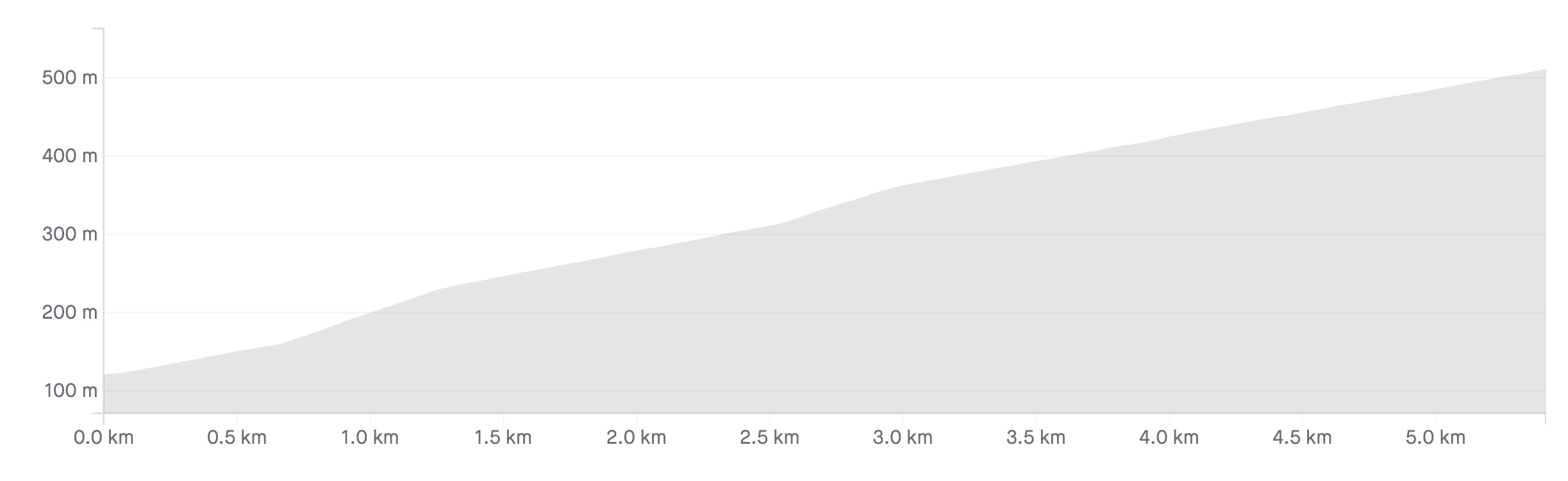
Climb details
The climbing begins as soon as you pass the intersection of Don Road and Badger Creek Road, sitting at a fairly reasonable 5%. 300 metres after starting the climb, the road flattens out slightly before bendly sharply around to the left several hundred metres later.
The sweeping left hand bend kicks the gradient up to around 10% before it flattens out at Old Don Road, 700 metres into the climb. At around 5% the road continues to wind upward, flattening out even further after 1.1km of climbing. Bending around to the left, the road continues to climb along the ridgeline at a fairly pedestrian gradient.
An incline of around 3% is maintained for over a kilometre, the road winding around to the right 2km from the start of the climb. A little after the 2km mark the road becomes noticeably more enclosed, with eucalyptus gums standing tall by the roadside.
At 2.3km, the road bends around to the left, the gradient increasing to over 10% in the process. While the gradient drops below 10% after the left hand bend, it still sits at around 8% as the road bends around to the right at the 2.6km mark. Returning to a more modest gradient in the next 300 metres, native ferns dominate the roadside area before great views are available to the right of the road.
At the 3.5km mark a steepish left hand bend turns the road toward the climb’s most distinctive turn, a very tight left hand hairpin. The gradient stays at around 5% as the road bends sharply to the left before increasing slightly out of the turn. 3.8km into the climb the road passes Malleson Lookout on the left, resuming a gradient of 5% as it winds through the thick native bush. Views of the Yarra Ranges National Park are now possible on the left hand side of the road.
At the 4.1km mark the road flattens off noticeably, continuing to climb at about 3%. This gentle gradient is maintained for the rest of the climb as the road winds gently through the trees. The climb comes to a close after 5.1km, opening out into the wide, dusty intersection of Don Road and Mt. Donna Buang Road.
Profile
Location
The northern approach to the Panton Gap begins 4.5km from Healesville, 65km north-east of Melbourne. To get to the start of the climb, take Don Road (C506) south out of Healesville until its intersection with Badger Creek Road (C505).
This climb concludes at the intersection of Mt. Donna Buang Road and Don Road and further climbing is available for those that are keen. The ascent of Mt. Donna Buang from the Healesville side is a beautifully scenic ride but is best attempted with thicker tyres as the road turns to soft gravel 3.2km from the Panton Gap. Be aware that the Panton Gap end of the Mt. Donna Buang Road is closed during winter.
If you are looking to follow Don Road over the Panton Gap to Launching Place, be advised that the road turns to gravel a few kilometres from the Gap. The 3.5km section of gravel is fairly firmly packed, however, and can be ridden on road tyres in the drier months.
Times
The Strava segment for this climb can be found here.
From the great descriptions and the comments given here, I relived my e-bike trip. Unfortunately, I could not view either the full profile, nor the Google Map. I am particularly interested in getting the elevations of Healesville, Panton Gap and the junction of Don Road with the Warburton Highway. Would appreciate your help. Thanks 🙂
Just type 19 Donna Buang Road in Google. Yes the entrance to the Nati0nal Park is locked but you can walk around the gate. I live there but always happy to see bikers coming up.
Age 69. The furthest I had cycled before doing this was on my cross trainer pushbike from Yarra Junction/Wesburn to Warburton (about 8.5 km). I decided to hire an e-bike in Warburton on a Sunday early in April and got as far as Launching Place with the electricity off. I went onto ECO on Don Road and when the going got steep I put it onto TOUR. I hasten to add that I still had to pedal – and hard- to get to Panton Gap. Luckily for me, the dirt road had recently been graded so was very smooth. I loved being amongst the trees with only the rare car. I was glad of the disk brakes for the descent into Healesville and for the return descent on the dirt road from Panton Gap down to Launching Place. I managed 55 km that day (returning the e-bike early the next morning). The weather was sunny and a pleasant 25 degrees. I admire all you folk who can cycle this with your own muscle power! I guess one gains muscles and stamina with practice. However, let it be known that for those of us who can’t yet manage it completely under our own steam, the e-bike is a way to enjoy this and other beautiful trips.
Recently just did this, was my last climb of the day, found it very tough, there is not let up, the nice views kept my mind off the pain i was feeling lol!
Is the Road from Panton Gap to Mt DB still in good condition and okay to ride on with a road bike? Or deteriorated too much in last couple of years? Would like to give it a try in a few weeks when riding from Healesville to Marysville via Reefton Spur. Thanks!
How does this compare to the first 4km of lake mountain? Is LM just constant steep gradient where as this is variable?
I’m hitting LM for the next time next weekend and was in my lowest gear up Panton today 🙁
Thanks
Coburg Cycling CLub did this as a group ride last weekend. Amazing Weather, started at Healesville Up Panton Gap to Mt Donna, down to Launching Place via Warburton and then up the other side of Panton on the dirt. Awesome place!
Did this cracking little climb today, the tight hairpin is brilliant. I couldnt help but continue on to the dirt road up Donna which is just a beauty to climb, just a tricky descent on the dirt.
Great site Matt you describe the climbs very well
We recently did this one from the south side (Launching Place). Once you get past the busy bottom section the ride up the Don Valley is beautiful and the gravel section at the top is not a problem for road tyres. The descent into Healesville is a blast.
I did this on the weekend and kept going to the summit, which I got to around 7pm with fog rolling in – very eerie and atmospheric. I had no touble getting traction on the gravel – maybe anyone really smashing their way up it looking for a record might find it different. Admittedly you probably wouldn’t want to go thinner than a 25mm tyre.