

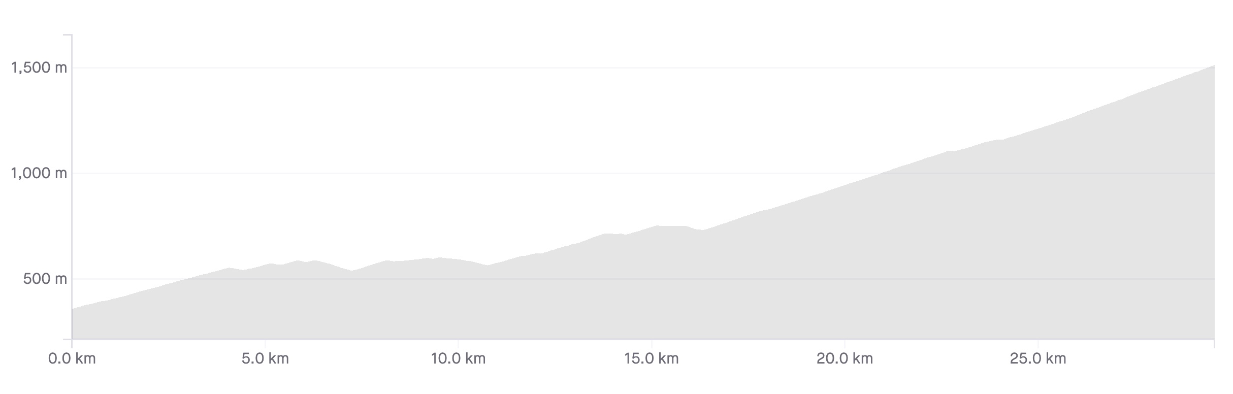
Length: 29.8km
Average gradient: 3.9%
Elevation gain: 1164m
Introduction
The climb from Mt. Beauty to Falls Creek* is one of the longest in the Victorian Alps and also one of the most picturesque. While there are several downhill sections and plenty of opportunity to rest in the middle section of the climb, the overall length means you’ll need good endurance to get through this climb.
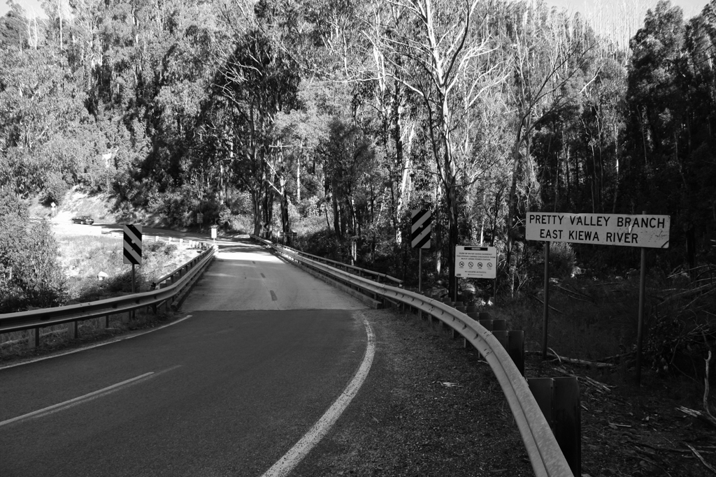
The start
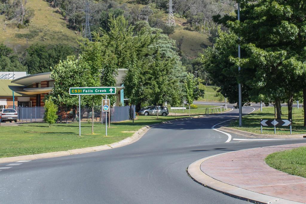
The Falls Creek climb begins at the roundabout intersection of the Kiewa Valley Highway, the Bogong High Plains Road and Lakeside Drive in Mt. Beauty.
The finish
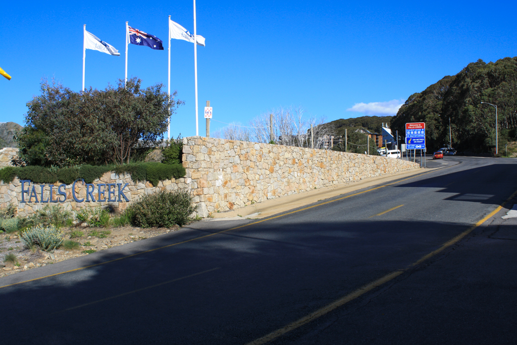
The Falls Creek (Mt. Beauty side) climb ends at the brick wall at the entrance to the Falls Creek Ski Resort.
At a glance
- A long and varied climb that can be broken into three distinct sections.
- The climbing is consistent for the first 4.2km until a right-hand hairpin.
- From 4.2km to 16.7km the climb is undulating with several flat sections and descents.
- The climbing from the bridge at 16.7km is consistent with only a couple flat spots.
- After the tollbooth at the 26km mark, the road gets slightly steeper.
Climb details
The climbing starts as soon as you leave the roundabout in Mt. Beauty and for the next 4.2km the road doesn’t really let up. After 700m of the climbing you’ll pass the Big Hill mountain bike park on the right-hand side of the road while the gradient sits at around 4%.
As the road begins to wind its way along the ridgeline you’ll get some great views on the left-hand side, particularly from the 1.5km mark onwards. The gradient fluctuates between 3% and 6% for most of the opening 4.2km section with the road winding gently from side to side. There are a number of sharper bends though — including a right-hander at 2.6km and a left-hander at 2.8km.
After 4.2km of consistent climbing out of Mt. Beauty (at an average of 4.9%) you’ll reach a right-hand hairpin where the road flattens off and you’ll start descending. This is the end of the first section of the climb so sit up and take a quick breather.
Over the next 12.5km the road only climbs 190m (an average gradient of 1.5%) and you’ll notice there’s a fair bit of descending in addition to the climbing.
Most of the first 700m after the hairpin at the 4.2km mark are downhill before the road heads up again for a couple hundred metres. You’ll descend again briefly for a few hundred metres before the road flattens off once more.
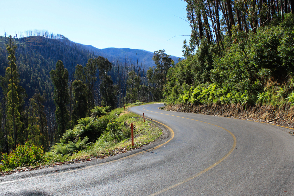
Over the next few kilometres you’ll cover a bunch of small rises and small descents and it’s not until the 8km mark that you’ll get to another section where the climbing is sustained for more than a kilometre. Take the time during this middle section of the climb to enjoy the views off to the left of the road. It really is one of the nicest stretches of road in the Alps.
Roughly 9km in you’ll descend briefly before climbing for another couple hundred metres. You’ll then descend and climb and descend and climb until 10.9km at which point you’re only 27m higher than you were after 4.2km.
But from that point on the climb is a little more consistent and apart from a few very brief descents (the longest being 300m long at the 14.5km mark which takes you to the Bogong Village) it’s mainly uphill until the 15.5km mark. At that point you’re 817m above sea level — the highest you’ve been on the climb so far — and you’ll spend much of the next 1.2km heading downhill until you reach the bridge over the East Kiewa River — the start of the third and final section of the climb.
The climbing from the 16.7km mark to Falls Creek is very consistent with only a few short sections where the road flattens off. As soon as you cross the East Kiewa River the gradient kicks to around 5% and it’s worth trying to find a comfortable rhythm quite quickly. When the road bends around to the left after 17.1km of climbing, you’ll notice lush ferns on either side of the road, a sight that you’ll enjoy throughout the final section of this gorgeous alpine climb.
After 17.5km the road bends around to the right then sharply around to the left before flattening out momentarily. At the 17.7km mark you’ll take a long right-hand bend which then opens out to views of the mountain ahead of you. 300m later you’ll reach another sharp right-hand bend, Junction Spur, which provides terrific views to the left of the road but has the tendency to sneak up on careless riders on the descent.
After 18.2km the road has flattened off somewhat and for the next couple kilometres you’ll wind your way gently upward with great views often available to the right-hand side of the road. By the 20.7km mark the gradient has returned to around 5% and beautiful ferns line both sides of the road once more.
After 21.5km the road has flattened off slightly again as it bends around to the left. 300m later you’ll head around a very sharp right-hander where the tree cover becomes noticeably heavier. The gradient remains gentle over the next few kilometres before a short downhill section at the 23.0km mark ends at a sharp right-hand hairpin at which point the gradient kicks back up to around 5-6%.
Before long the road has flattened off slightly once again and after a sharp right-hander at 23.7km and a long sweeping left-hander 100m later the road winds its way along the ridgeline and into another slight downhill after 24.3km. At the 24.5km mark you’ll reach one of the climb’s most iconic bends, a very sharp left-hand hairpin that kicks the gradient up to around 7% for a couple hundred metres.
With valley views now possible to the left of the road, the gradient returns to around 3-4% at the 24.7km mark and the gentle winding continues. For the next kilometre or so the road winds left and right through beautiful ferns and native eucalypts with the gradient fluctuating between flat and around 4%.
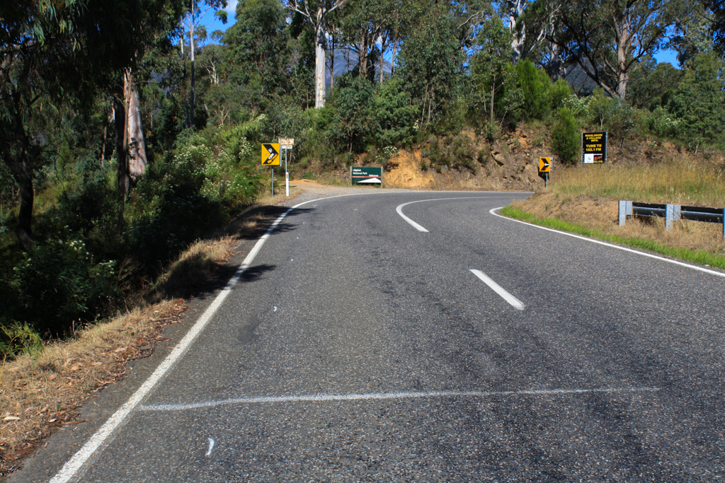
After passing the Howman Gap YMCA building at the 26km mark the road has emerged from the trees and shortly after you’ll pass the Falls Creek tollbooth on your left. At this point the road becomes fractionally steeper.
For the remaining 3.8km the gradient sits at around 5-6% as the road winds its way ever closer to Falls Creek . At the 26.9km mark you’ll pass through a steep little left-hander and 400m later you’ll bend back the opposite way as the road sweeps tightly around to the right.
After 28km of climbing you’ll catch your first glimpse of the Falls Creek Ski Resort which only serves as further motivation to get through the remaining few kilometres. Climbing at around 5% the road winds its way gently along the ridge with valley views available on the left-hand side of the road.
At the 28.6km mark the gradient eases off slightly and 800m later you’ll bend around to the right and catch a fuller glimpse of the resort ahead of you. From this point it’s roughly 400m to the end of the climb, as designated by the end of the brick wall, opposite the Gateway Cafe.
Profile
Location
Falls Creek is located around 400km north east of Melbourne in the heart of Victoria’s alpine district. Driving from the state capital to Falls Creek makes for a long day behind the wheel, taking over 5 hours via the Hume Freeway (M31), Great Alpine Road (B500) from Wangaratta, the Tawonga Gap Road (C536) from Germantown and the Bogong High Plains Road (C531) from Mt. Beauty.
Popular launch sites for an attempt at the Falls Creek (Mt. Beauty side) climb include Bright (including the Tawonga Gap climb as a warm-up), Mt. Beauty or any number of other townships in the area.
Times
If you’re the sort of cyclist that likes the added challenge of racing against the clock, why not see how your climb compares to others? Click here to see the Falls Creek (Mt. Beauty side) climb on Strava.
Flyover
*Note: this page was updated on May 1, 2013 to cover the full climb from Mt. Beauty to Falls Creek. It previously only covered the final 13.2km from the bridge over East Kiewa River to Falls Creek.
of note here if you are doing the 7 peaks there is a after hours stamp outside the cafe. I havent seen this at any of the climbs but it is a great idea
WATER!!!!!!!!!! yes, there is water at the toll booth. there is a little tap between the two booths and water is good for drinking. i ran out of water before i even got there. when i reached the resort, guess what? all thinkgs closed and no water. luckily i asked another rider who told me about the tap at the toll booth. after a quick look around, i raced down and filled up. aahhhhh, thats better.
30/3/14, last chance for a 7 Peaks Stamp and I wasn’t leaving empty-handed! Stunning terrain, along with perfect conditions: light rain cooling me down on the way up and then the sun coming out at the top for the roll down (with some short rises back up in the middle of the descent).
Reasonably gentle all the way, just really long if you’re not used to length – I wasn’t, apparently. That last 4 kms got really weird for me… After stopping for a bit at that handy vending machine it took me ages to get to the village from Howman’s Gap! Embarrassing ultra-slow grind aside, it was great to roll up to the ‘real’ village (past the oversnow terminal) and get that stamp.
If you’re hardcore about it, or REALLY determined not to miss out on a 7 Peaks stamp (a bit of both for me), it’s definitely doable in a day: driving up from Melbourne, enjoying a gorgeous climb and then driving back home in time for dinner. I left home at 6:30 via the M80 from the east, got in to Mt Beauty at 10:45 and started climbing around 11. I’m not really that fit or “in-shape” either, but I managed it pretty easily!
A suggestion for those driving to Mt Beauty- avoid Tawonga Gap and take the Happy Valley Rd turnoff just after Myrtleford. Assuming you’ve got the petrol, it seems to be quicker than winding up and down Tawonga Gap and slowing down through the towns along the Great Alpine Rd.
This is great! I’m riding this tomorrow for a charity ride on a tandem bike with a blind person on the back. This is gold!
Thanks Matt! Saved the day! $2 water at the vending machine at the toilets just before the toll booth.
Does anyone know where to so and refill water bottles on the way up? It’s gonna be a hot one tomorrow!!
There’s a vending machine at the tollbooth (4km to go). Not sure where else! If the store/restaurant in Bogong is open (no guarantees this time of year!) they might be able to help.
Is the last few km really only 5-6%? It feels like more after the rest of it. I did think sections hit 8% though. Thanks for the update with the bottom half included.
In 3 Peaks it felt like a brick wall and the downhill bits were far too infrequent! The whole time I kept thinking “it’s only 5/6% that’s nothing”, but the bodies littered on each bend made it clear that’s not the case. Thanks again.
G’day Matt, I’ve always considered the FC climb really starts from Mount Beauty so it’s about 30 km all-up from Mount Beauty to the resort. How would this change the rating of the climb? Thanks for a great resource with the site. Cheers, Owen.
Hi Owen, stay posted. 😉
Having ridden both climbs on a number of occasions, I’d say Matt’s rating is accurate: Falls Creek is considerably easier than Donna Buang.
Matt’s profile doesn’t include the initial climb and (short) descent from Mount Beauty to Bogong Village, which you have to do on the way to the bottom of the Falls climb proper. It’s about 30 km all-up from Mount Beauty, and there’s over 1000 metres of ascending in total. Even so, it’s not steep, it’s just long.
If you want to add a bit more climbing to your ride, the road doesn’t actually stop ascending at the village, though the “Falls Creek climb” ends by tradition there. The road continues to climb about a kilometre further up to the Rocky Valley Dam.
Last I checked if you go past Falls, the total length of the climb is about 15.7km.
mmmmm, cat 2 ?? not really in agreement with that. reckon its more cat 1, as its arguably the same difficulty as Donna Buang, which you’ve ranked as cat 1. In fact Donna is easier, as its a consistant gradient, whilst Falls is continuosly changing its gradient, which makes it very difficult to get into a good tempo on.