

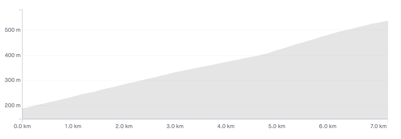
Length: 7.2km
Average gradient: 4.8%
Elevation gain: 349m

Introduction
One of the most frequently ridden and most popular cycling roads in all of Victoria, the main climb to Kinglake is one that all Victorian cyclists should attempt at least once.
The devastating bushfires of February 2009 that killed 173 people also burnt out most of the trees on the roadside, providing phenomenal views into the valley below as you climb toward the township of Kinglake.
The start
The start of the climb is designated by the winding road sign as seen in the photo below. This can be found on the Heidelberg Kinglake Road (C746), roughly 6km north-east of the township of St. Andrews.

The finish
The Kinglake climb ends at the second set of 60km/h signs as the road flattens out, just before the township of Kinglake.

At a glance
- A very popular ascent that can be seen as two climbs in one.
- The first section, lasting 4.8km, winds along the ridgeline with a gentle gradient.
- The second section, from 4.8km onwards, is noticeably steeper than the lower slopes.
Climb details
After the first couple corners, you’ll find yourself precariously balanced on the ridge line where you’ll remain for the first 5km of the climb. The initial gradient of around 4% is maintained for these first 5km and indeed the climb can be divided into two distinct sections.
The first sees the road wind narrowly along the ridge line at a modest gradient before the second half, beginning at the 4.8km mark, sees the road heading away from the ridge line, straightening up slightly and increasing in gradient.
While you shouldn’t need to be reminded to keep left while on the road, it is especially important on the climb to Kinglake where the road is so narrow in parts that only one vehicle may pass at one time. The descent, too, should be handled with care as cars coming up the hill often cut corners.
Profile
Location
The Kinglake climb is accessible from Melbourne but a round trip from the city to Kinglake and back will add around 120km to your odometer. Various routes can be taken to get to Eltham in Melbourne’s north-east, but from there it is a matter of following Main Road to the north which turns into the Kangaroo Ground St. Andrews Road (C728).
Once through the town of St. Andrews you’ll find yourself at a t-intersection where a right turn should be taken onto the Heidelberg Kinglake Road (C746).
Times
Being one of the most popular climbs in Victoria, the Kinglake climb has many riders attempting to set personal best times or see how their times compare to others within the community. If you are one such rider, check out the Strava segment for the Kinglake climb.
It’s a bit difficult to do that loop without riding on Melba Hwy, so how can we ride the loop *and* avoid that highway?
Update your will and life insurance when u do this ride….
Nearly crossed of last weekend by a guy doing 60k rd a 30k signed turn and than abused and told he would hit me next time
Zero shoulders and 50/80 meter fall drops on the ascend good luck hope you make it I won’t do that ride anytime again in a hurry
I want to live! Most scary and dangerous ride I’ve ever done
I don’t cycle.
Cyclists have as much right to the road as cars.
Abusive drivers should cop a minimum 6 month licence ban.
I encourage all cyclists to carry a dashcam (helmetcam?) & report drivers to the police.
The utter arrogant entitlement of drivers.
Climbed this just before Christmas. It’s been on my climbs to do list for a while. I started in St Andrews and found the first half easy but as soon as I rounded the left at Mt Everard track, the gradient hit hard and I had to pull over to catch a breather. Getting going again was hard but I somehow made the top of the climb and once I finally reached Kinglake the feeling of achievement was awesome. So I’m going to go hit it again soon.
No issues with traffic, every driver or motorcyclist was very respectful and gave me room or waited till they could see the road ahead before passing me. Never tried on curves despite my crawling pace.
Probably need to mention that the Kinglake CFA and SES and air ambulance are on this road every weekend cleaning up after accidents caused by impatient drivers.
But don’t let that stop you.
Really, the 7 km stretch of fairly steady gradient doesn’t really fully encompass the “pleasures” of this climb.
It is 24 km from the Wild Wombat in Hurstbridge to the top of the Black Spur West of Kinglake on the road to Whittlesea (C724). The elevation gain is 570 m. The first 12 kms are pretty easy climbing net 80 m but a bit undulating. You are then faced with a wall. I was down to my second lowest gear and lasts for about 700 m. Then a couple of lumps takes you to the beginning of “the climb”. Once at the top of “the climb”, it’s pretty flat heading west thru Kinglake then kicks up again for another fun filled 100 m of vertical. I finished my ride by continuing down to Whittlesea then Arthur’s Creek and back to Hurstbridge via Nutfield. Very pleasant.
I am a nervous-nelly but I didn’t feel too insecure riding this route. However, I did witness the aftermath of a 2 or 3 car accident when 1 of the cars (descending) sideswiped 1 or 2 ascending cars in convoy probably cutting a corner at speed. So perhaps there is something in what people are saying about this road being a tad unsafe for cyclists.
Did this climb on the weekend as my first climb of the season. It was good to see on the descent that many of the key corners have been recently resurfaced with something much smoother. The surface treatment applied last year had a tendency to become quite gravelly with loose stones.
Perhaps the email from an earlier poster to VicRoads had some effect after all?
Rode up to King Lake yesterday with a few mates. Found the ride to be very safe as long as you stay on the left side of the road. The road is very good. The descent is made easier with the upgrade of the road.
Rode this climb twice in 2 weeks. The road surface is very smooth, traffic is relatively low. The climb and the descend are really safe, not dangerous or “suicidal” at all.
Apparently, this is sometimes different according to the other posts.
In my opinion, it is absolutely absurd that the drivers of cars are complaining about cyclists on the road, since cyclist are not the ones killing other people on the road.
Yes, some times you need to get your foot of the gas for 2 seconds if you are passing a cyclist, so what?
Drivers who do not understand this need to get real. In 5 years this climb and many more in victoria will we crowded by cyclists, so they better get use to it and share the road.
The road is OK again. Most of the excess loose gravel from the re-work has been ‘brushed’ away by the other road users.
Descent was fine last weekend (though a tad damp).
Except that everyone in Kinglake calls you all “Suicyclists” and our town is fighting to have cycling banned on that road forthwith.
A Kinglake SAS soldier’s opinion is that it’s safer to serve in Afghanistan than cycle on the windy road….
That’s an interesting opinion
To date there have been 41 deaths and 261 injuries to serving Australian soldiers in Afghanistan.
In the same period there have been 0 deaths and 8 injuries on the road to kinglake involving cyclists.
Your brave SAS solider should know the difference between perceived risk and real risk. While cycling up the mountain may seem dangerous, the actual facts bear out a different story; that of hundreds of cyclists using this stretch of road every weekend without death or injury.
The reality is that the residents of kinglake are annoyed at a slower group of road users upsetting their use of the road for a few minutes at a time.
Since vic roads deliberately destroyed much of the surface in December 2015 it would now be the worst climb in Melbourne.
Go somewhere else.
Vic roads response to my email.
“As you mentioned, the road texture of the surface has now changed. This was the intention of the treatment applied, intended to provide motorist with greater surface texture making the road surface safer to drive on as more vehicle tyre grip is achieved.
As you are aware this location of road is very curvy in some areas which in turn requires road surface to have optimal road grip for motorist. (But they have only done part and not the worst part)
VicRoads surface treatments are nominated depending on risks and needs of the site. The treatment selected for this site was based on these attributes”
I’m pretty sure they were thinking of De Laurens as there are a host of more modern high grip surfaces than that.
pity
Completed this climb for the first time today, and very pleased to have completed it in relative ease. Actually I found the first part up and around the corner the most difficult. Once again, great site, I’m ticking the climbs off as I go!
As a local and someone who has to drive along this road frequently I believe that this road is unsafe for cycling on, I have grown up in the township and have seen many many near misses for cyclists and vehicles alike caused by cyclists, I have almost had head on’s with other vehicles who were trying to overtake on this narrow and windy road. This particular road is one of three main roads leading in and out of Kinglake and for some, using this road for transit is unavoidable( meaning this road is the most efficient road to use for transit for many destinations). Myself, family and friends that frequent this road all believe that this road is unsafe for cyclists to ride. The road it’s self is very narrow and windy which means that there are no safe spots for passing cyclists safely and I fear that if there is continued use of this road by cyclists there will be a tragic accident in which a cyclist may be injured or killed. There are enough maniacs driving cars around on this road so why make it worse by including unnecessary overtaking into the mix. I personally don’t want to be involved in or even hear about a fatal accident on this road.
Before commenting and asking why I’m writing in this site I’ll give you my reasoning, I frequently use this road and want the cycling community to hear what the locals of Kinglake have to say, I have not met one single local that is pro cyclist on this road (Please note this is all in relation to this road and no others, I am perfectly fine with cyclists sharing the rest of the roads within Australia and the world 🙂 I am only worried that there will be an accident)
Interesting how there’s no mention of reigning in the ‘maniac’ drivers and ‘nobody’ in the town is pro-cyclist. No sure if you asked the bakery folk that one.
I’ve been up & down Kinglake heaps of times, binned it twice (lightly) and respect the road to the conditions… I’ve also had plenty of experiences where I’ve had cars respectfully pass me after I’ve waved them thru, as riders (out in the open) can sense the right overtaking conditions that drivers cannot (within their sensory-diminishing cabins). You won’t understand that however unless you ride.
Stats also show that rider/driver accidents are a drivers fault around 80% of the time, so rather than talk about diminishing a cyclists right to a certain piece of road, perhaps you should just take more care and realise that drivers don’t own the road, they own a car.
As do many riders.
@nathman.
Well said. I could not agree with you more.
I drive ride a motorbike and cycle. There have been many occasions where cyclists have been manically waving me to overtake in their wisdom. Stop it. I will decide if it is safe for me to overtake. If I had taken the cyclists advice I would have, on different occasions, had a head on collision with oncoming cars around blind corners and on more than one occasion cleaned up a motorbike. Cyclists should keep their assumed better knowledge because they are out in the open to themselves. The decision as to whether a car overtakes safely is up to the driver of the car and what they can safely see. This is a dangerous road.
I am a Kinglake local.
I am “pro-cyclist”.
Almost every other “local” that I know supports shared use of all roads by all legal road users.
Both drivers and cyclists have a legal obligation to take care of other users on the roads.
Had my first experience of climbing up to Kinglake as a Hurstbridge return trip this recent weekend. I was very unimpressed to find the road surface turning into a melting sticky mass about half way up the climb, weeping stones that got stuck in my tyres and had to be removed at regular intervals. I wondered that surely this could not be its usual state or I would have expected to see comment about it on this site? It was not much fun on the descent either. Can anyone advise me as to whether this was its usual condition or did I just have the misfortune of coinciding with resurfacing works? I be keen to know before planning any future visits.
The road surface has been re-laid recently, and on descending a week or so ago I passed some of the heavy machinery.
You can take the Eastern Bike path out to Park Orchards and then through Warrandyte to St Andrews. Another alternative if that seems a bit hilly is to go to Hurstbridge by train and then head straight up to KL or as an alternative through Nutfield (Mine and Hildebrand Roads) to the back of St Andrews and up to KL. Enjoy it.
Thanks Alex, good tip.
Hi, thanks for this information. I’m just wondering what the safest route is from North Fitzroy out of the city to Kinglake? I’ve done the Humevale ride and Plenty Road was just too hairy and took the fun out of it. Thanks, Martin
Hi Martin, this is a popular option: http://ridewithgps.com/routes/8188338?privacy_code=rh753Pawt3ioI2Fx
It takes you on some nice backroads out to Eltham and then follows the main road out to Kinglake via St. Andrews. Enjoy!
Perfect, thanks Matt. Will give it a run in the coming weeks.
that route certainly works. as an added treat, when you get to point 20 on the map take the right onto Mt Pleasant Road – there is a sign to Montsalvat. Stay on that road until you come to a T Junction – it’s preceded by a steep pinch, you will know when you are on it! From there a right onto Research Warrandyte Rd and left onto Bells Hill Rd will take you to point 27 on the map. The roads are much less busy, nicer riding, and more testing
Mike
I did this today (today is midweek Winter.
I left from Diamond creek, went to the top and back (59km rtn)
This is a real pretty ride.
I didnt find it that difficult, but I wasnt trying to post a great time.
Strava says its Cat 2, I dunno it didnt feel it.
The road is very narrow, but there wasnt much traffic on the road. Nevertheless, as expalined in the summary, good to keep very well left.
I’ve driven the route but never rode it. Been looking to test out my legs for an extended period so I think I’ll give this a shot. The drop off on the left of the road even as a driver made me wary of riding the climb
will b going up kinglake for the first time this saturday with a couple of friends….hope to catch a bunch of riders to ease the burns…. 😉
Get all cyclists off these roads. They are a menace to themselves and drivers!
Says the selfish, probably fat and lazy, driver who doesn’t appreciate the value of business the cyclists take to Kinglake on weekends.
Why both commenting on a cycling website then pal??
Jon Spencer, your a tool!
Very good description and rider information. It’s a good solid hit-out and represents an excellent base ride if you’re wanting to add some fitness and strength to your cycling. Very popular with intermediate to strong riders who are serious about their training regime.
The Strava Link on this climb is not at the same locations, it seems to start and finish before the signs pointed out. There is a (Cycle2max version) that is spot on as far as first yellow sign and lst 60 sign. http://www.strava.com/segments/kinglake-cycle2max-version-629743
Thanks John, all fixed.
Has anyone tried the climb out of Wallan up the South Mountain Rd then the Main Mountain Rd that gets pretty close to the highest peak in the area (Mt Disappointment)? The road surface looks OK from the little I can tell from Google Maps/Satellite view (no street view unfortunately).
I used to live at the bottom of the Kinglake climb. Went through a period when I couldn’t sleep, so I would do the ride in the moonlight, about 3am. Could go up and back and not see a single car, but the wallabies were a worry!
Catch the train to Hurstbridge; alternatively, catch the train back from Hurstbridge, particularly dependent on the wind. Remember a key cycling motto: “Don’t ride like the wind; Ride with the wind!”
Good work Tooraj. There are some routes that ‘make’ us as riders, Beach Rd for learning how to ride in a group; the ‘Round the Bay in a Day’ for riding longer distances; Kinglake for climbing (& Macedon, & Donna Buang…); and the 3 Peaks Challenge for testing yourself beyond what you could think was possible. All great achievements.
Thanks for the details of this route. You’d be pleased to know you have inspired me to ride to Kings Lake and I loved it! I have just gradated from a hybrid to a road bike and been enviously noticing the folks wearing their Kings Lake jersey quite proudly.
I found the road condition and surface quite good. The road was clean without any debris and the traffic was very light and slow moving (this was on a Tuesday morning around 8:30).
Note, if you are afraid of heights, you will find riding some sections along the cliff edge with no to little road shoulder quite daunting. 🙂
Love your web site.
Thank you
Well done Tooraj!
A great alternate return route is to take a right at the main roundabout and down through the beautiful forest road to Toolangi. One of the most beautiful descents, then you’ve got the option of coming back via Healevsille and the Christmas Hills. Good coffee on the can be found at Picollo Mecannico in Diamond Creek, and there’s a new place in St. Andrews which also does a mean coffee and great wood fired food.
As of 4 Feb 2012, the road has been resurfaced at the last 1.5 km or so of the climb (the straight section adjacent to Jehoshaphat Gully) to now be a gritty, Alpine type surface. Riders should beware that there was a great deal of loose gravel covering nearly all of the descending lane. If you’re descending the same climb, be careful!
Also, the Bakery appears to have closed. But, there’s a cafe next door, doing a roaring trade.
Thanks for the update Trevor!
Not many people seem to know, but there is a fantastic 30km loop add-on to riding Kinglake. Turn right at the roundabout at the top of the Kinglake climb, heading to the Maroonda Hwy. Left at the highway, use extreme caution single file only. A few ks along on the left is the Old Glenburn – Kinglake Road. Turn here and you will be rewarded with another magnificent climb back up to Kinglake and it makes the coffee at the backery even more rewarding.
Happy Riding, Rob
I did this additional loop yesterday, and aside from the wind and two lots of rain in and around King Lake, it was a good little climb back up to KL.
You mean Melba Hwy, not Maroondah Hwy
Thanks for the Kinglake-Glenburn Rd tip. I’m going to try that.
We had a go at the Glenburn Road climb yesterday. We took Robert’s suggestion. Starting at Kinglake, we took the Mt Slide Road to the Melba Hwy. At the Melba Hwy, we turned left. We then rode down to West Bridge Road and turned left. This took us to the base of the Glenburn Road climb.
The Glenburn Road climb is a beauty. The road is quiet and picturesque. The climb has three parts; a flat section at the bottom followed by 5km of 5% followed by a few more kms of rollers.
I found the Melba Hwy section a bit hairy. There was lots of fast moving traffic to contend with and the shoulder wasn’t very wide. The next time I do this climb, I’ll stick to Glenburn for both the descent and the climb.
I did the Glenburn Road climb yesterday, is very scenic, virtually traffic free, the road surface changes throughout the climb but is very nice and quiet, Melba highway should be avoided, as said previously very busy with traffic/trucks etc…………. not much room for cyclists.
Just xn update on the precautions regarding road conditions. The road is 2 lanes all the way, there are no single lane sections. The descent needs to be taken cautiously due to several left hand bends that tighten in on you and numerous blind corners that are often cut by cars,
Also, after heavy rain the road is usually littered with fallen rocks and gravel do take care.
Cheers,
Anth
One of my favourite climbs and thanks to its proximity to Melbourne, my most frequent. It’s a 100km round trip from the city with a coffee break at Hurstbridge.
That’s a nice ride but the traffic can be a bit hairy.
Try Bald Spur Rd to the West.
You’ll need an MTB.
I have never managed to ride it non stop – but will one day.
Just clarifying the finishing point. It’s at the second set of dual 60kph speed signs closest to the roundabout. The first set of dual 60kph signs measures the climb as 6.88km on my Garmin.
I can’t tell which set are in your photo above, so perhaps a clarifying comment in your description would be useful.
BTW – love your site. Thanks for all the effort you go to!
Hi Anthony. Thanks for that – yep, it’s the second set, closest to the township. I’ll clarify that now. 🙂
Done this one a few times. Good fun ride, even an amatuer like me can manage it.
Yep, it’s a nice gentle climb. 🙂 Thanks for stopping by and leaving a comment.