

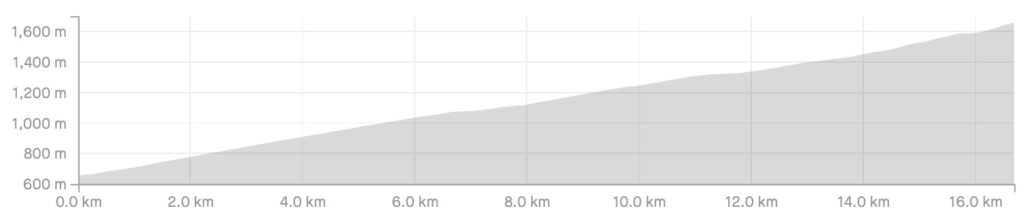
Length: 16.8km
Average gradient: 5.9%
Elevation gain: 985m

Introduction
The climb up to one of Victoria’s favourite snowfields is among the most picturesque in the state. Rising from the small township of Mirimbah, the ascent of Mt. Buller is fairly steady throughout but with a final few kilometres that are very steep and pose a great challenge for cyclists of all abilities.
The start
The ascent of Mt. Buller begins at the toolbooth in Mirimbah.

The finish
The ascent of Mt. Buller ends at the Arlberg Hotel — the point where the surface of Summit Road changes from concrete to gravel. Alternatively, the climb can be finished at the entrance to the Mt. Buller Alpine Village, as per the blue distance markers that can be seen throughout the climb.

At a glance
- A consistent and picturesque climb with a few flat spots and steeper sections.
- The steepest section is Hell Corner at 14.9km — a left-hand bend with a gradient of ~13%.
- The optional climb from the village to the Arlberg Hotel is steep (10%+) but with great views.
Climb details
As soon as you pass the tollbooth in Mirimbah the climbing begins. The initial stages of the climb seem fairly challenging at around 6% but after a couple of kilometres it’s easy to get into a rhythm and enjoy the amazing scenery that this climb has to offer.
Passing through a thick covering of eucalyptus gums and lush ferns you’ll take two beautiful sweeping left-hand bends at 3.2km and 3.5km into the climb. At the 4.1km mark the road bends right exposing breathtaking views on the left that remain possible until 21 Mile Pit around 900 metres later.
While the average gradient of the climb is 6% the actual gradient fluctuates noticeably throughout the climb. There are several steep points throughout but these are almost always followed by short flat sections that allow you to catch your breath. You will also notice blue signs throughout the climb which show the elevation at that point in the climb and how far away the Mt. Buller Alpine Village is.
After 5.9km of climbing the road narrows slightly and more amazing views are available. 800m later the road flatens for a couple hundred metres passing the distinctive rockfall barrier and waterfall of White Bridge. At this point the road becomes considerably narrower and windier and stays that way until the Mt. Buller Alpine Village.
Climbing out of Chalet Creek, 7.9km from Mirimbah, the road bends sharply around to the left and you’ll be presented with the steepest part of the climb thus far. 9.0km into the climb, at Unnamed Corner, the road bends sharply again, this time to the right, with the gradient picking up slightly in the process.
The next couple kilometres feature several hairpin bends as the road winds through beautiful native bushland including Pump Inn Corner and the very sharp hairpin left at Boggy Corner, 11.9km from the start of the climb.
At the 13.7km mark the road emerges from the tree line and several ski lifts are visible ahead. 300m later you’ll pass under a chairlift suspended just above the road, reminding you Mt. Buller is one of the most frequented ski resorts in the country.
After 14.4km of climbing the turn-off to Mt. Stirling can be seen on the left with the road bending right and tilting upward into a very challenging final few kilometres.
At the 14.9km mark you’ll come face-to-face with the steepest part of the climb: the aptly named Hell Corner. At around 13% Hell Corner is followed by a steep hairpin right 200m later before the road eases briefly and then climbs sharply for the last few hundred metres to the Mt. Buller Alpine Village.
While the blue distance markers designate the Alpine Village as the end of the climb, the true finish is a further 900m up the road. In this case, the word ‘up’ is meant literally as this last section is a sustained climb in excess of 10%.
From the entrance to the Alpine Village at 15.9km, take a right turn onto the Mt. Buller Summit Road and continue up the last stretch to the top. The end of the climb is designated by the Arlberg Hotel found on the left of the road just before the road surface changes to gravel.
Profile
Location
Mt. Buller is located around 270km north-east of Melbourne and is a truly alpine climb. While day trips to Mt. Buller are frequently made by skiers in winter, the long distances and strenuous climbing puts this climb out of reach of most day-tripping cyclists from Melbourne.
Accommodation is available in many of the neighbouring towns and with the terrific cycling country that surrounds Mt. Buller, an overnight stay or weekend in the area is ideal.
From Melbourne, Mt. Buller can be accessed a number of ways. One option is to take the Hume Freeway (M31) north from Melbourne, turn right onto the Upper Goulburn Road (C383) just before Tallarook, turn right onto the Goulburn Valley Highway (B340) at Trawool and then take the Maroondah Highway through Yarck and Bonnie Doon.
Another option is to follow Maroondah Highway east of Melbourne through Healesville, Marysville and Alexandra before turning right at Yarck.
Mt. Buller can be attempted from Mansfield for a 94km round trip or, for a shorter warm-up, the 12km ride from Merrijig is also a great option. The road from Mansfield to Mirimbah is through true rural areas with very few towns in between. As such, make sure you are adequately prepared with food and drink and in the case of mechanical difficulties.
Times
A Strava segment for the Mt. Buller climb (minus the final kilometre or so to the Arlberg Hotel) can be found here.
The guide says Mt Buller from Mansfield is a 94km round trip though google maps has it at 84km, I am just planning my ride, which is correct?
Delayed reply – but yes. Ive done the Mansfield Merimnah (base of Buller) dozens of times – It can be a little hairy with the traffic.
So Mon morning off I went from my starting point of Merrijig hitting up climb number 2 on my 6week riding mtb and Rd trip. Merrijig is a great start point allowing for a cruzy rolling 250m of accent to warm into it.
Hitting the start of the climb at marimba, for the next 14km I mostly tempoed too the upper section, only easing up to eat on a couple of occasions.
With a few k’s to go and the first glimpse of the alpine village, the more difficullt switch backs were on me, so as required, out of the saddle I got to grind through Hells corner & the last ditch effort too roll into the village for the official end of the climb.
But I was never going to end it here fully aware that their was the most difficult yet 1km ahead. Making a right turn took me up a rather steep & sweeping section of Rd through the village to the top most hotel finishing where the concrete ended and the rd less traveled began.
Not much left to add but gees the decent was alot of fun, endless sweeping cambered corners one after the other.
Onwards to bright now for the national mtb champs a spin up Bufflow and then some
I’m wondering if anyone knows how many times you’d have to climb Mt Buller to complete the ‘everesting’ challenge?
Does it work out to be about 9 x times from the entry toll gate to the Arlberg Hotel (to make the 8,848m)?
Yep, nine: http://www.strava.com/activities/116766080
Heading out there this weekend, and im wondering how it compares to donna and lake mountain?
cheers.
A long time after the initial query, but for the sake of those who are curious: I haven’t done Mt Donna Buang, so I can’t compare that ride to this. But, having done Mt Buller today, and Lake Mountain three weeks ago, I think I can honestly say that this ride is a bit tougher than Lake Mountain. With Lake Mountain, the hardest part is at the start, and it then flattens out (relatively speaking) into a fairly straightforward climb. Mt Buller, on the other hand, starts, and then keeps going… and going… and going… and going. The last kilometer, especially, mocks you with a greater gradient than you’ve seen earlier in the ride.
Still a fantastic ride, mind you, and I’m happy to have done it (two of the Seven Peaks down, five to go.) But in all honesty, I think if you struggled with Lake Mountain, you probably shouldn’t look at this one until you’re better able to handle climbing.
I did Buller for the 2nd time yesterday.
After doing lake mountain twice the week before.
I have to agree that Buller is def harder than lake mountain, I think it’s the consistently higher gradient.
The last 2km are interesting too, I remembered hell corner but forgot that the remaining 2km were noticing higher gradient than the remainder of the ride.
There’s a couple of nice bits in there where you can get up some great speed ?
Awesome climb, one of the best! I finished it on the Friday afternoon (21/02/14) just before the Domestique crew swamped the area. It was nice to get some encouragement from some early arrivals driving up/down the mountain! The danger (both for my ego and my time/average speed) was that I probably took it way too easy at the start on the way up, anticipating the difficult end destroying me, but it was all pretty manageable (I think I’m on a 36/46, and I’m *really* heavy). I’m feeling a lot better about the rest of the Peaks now! Thanks for the details again: the analysis of Hell Corner and the finish made it that much easier, despite it making the ride longer.
Excellent summation of this climb! Did it last friday (29th November) and loved it. Perfect conditions with maybe one car passing me on the way up. Got myself into a real good tempo – only shifted out of the 22 tooth cog on my 11-28 cassette for Hells Corner. Very friendly lady in the tourist information centre (she gave my 7 peaks passport two stamps!). Very happy with my sub 60 minute effort without every going into the red. Only downside was I got sick on saturday so my plans to climb Mt Buffalo on Sunday morning were shelved (albeit temporarily until later in December).
Doing Mt Buller this weekend I hope the weather is better then what has been described . I did Lake Mountain a week ago with a 25. – 12 rear learnt a big lesson . I have now purchased a 28. – 12 rear and a compact front. Hope this helps.
Went out to Mt Buller last weekend for two days of Mt Buller repeats. Even though the weather was worse on the Saturday with snow showers falling to around 1,100m , I was allowed through the gates and rode till the slush got too thick and the snow too heavy. Turning around at Andrew’s car park lap one and Box Corner the subsequent 3 laps for a total of ~45km climbing.
Learn’t the hard way that it really depends on the day and who is working at the entrance if you are allowed on the mountain. On the Sunday cars weren’t having to fit chains and the weather was looking a little better. So I was keen on another couple of laps but I was stopped! Reason given is that once the toll opens, VicRoads hand control of the road to the resort and although not mentioned anywhere that bikes are banned we are a hazard with numerous buses and inexperienced drivers making their way up the mountain!
So if you want to ride Mt Buller during the Winter season, access will be hit and miss depending on who is manning the entrance station.
Hi rode the 89 or 90 addition, robert Crowe won, Gary clively second, Jeff Stewart third, ago giramondo 4th and I was fith. Omar Palov I think was sixth. I can’t remember snow but it was bloody cold. I made the mistake of following Palovs wheel, I had just finished reading a rough ride and he had ridden the Tour de France….
marco, i dont have any photos of the race, but i sure remember it. I think that was the year Robert Crowe won?? He won the road race and criterium and it sure snowed that week-end. There was another year when Peter Besanko won in the snow – it was late October/early November… The year after i was 3rd amateur (20th including the pros) and it was won by Bart Bowen, who also won the Suntour that year. That was the Melbourne to Mt Buller edition. Cannot find any info on this great race, even on google. Does anyone have any info circa 1990-1994?
I participated (and placed 2nd) in the Melbourne to Mt Buller race back in 1989. It was snowing the whole way up. I was wondering if anyone out there has any photos and/or documentation of that awesome event? Marco Vermeij (Netherlands)
Hi Marco. Thanks for stopping by the site. 🙂 I hope that someone sees your comment and has some information!
Wow, the last 2 kms of Buller hurt!! The climb is not so bad (even I was coasting a little) until you get to the Mt Stirling turnoff. From there it was steep the whole way. “Hell Corner” is aptly named. I was surprised by how much climbing there was from Mansfield to Mirimbah too – my bike computer said I climbed almost 500 meters in the “warm up”.
Hi please consider including Mt Baw Baw.
Regards John
Hi John. Thanks for your comment. Mt. Baw Baw is certainly on the list of climbs to be added to the site. As soon as I get a chance to head out there to document it, it will go up on the site. Thanks again. 🙂
John, if you haven’t already seen it, the Mt. Baw Baw climb is now on the site. 🙂