
Route: Lake Placid, Jay, Wilmington loop
Distance: 76km
Duration: 2 hours 56 minutes

At Lake Placid I rode a rental bike courtesy of High Peaks Cyclery. Thanks very much to Brian Delaney and his team for their help and for supporting the site.
After staying in New York for a little less than a week, I had a decision to make. My brother Ash, with whom I was traveling, was about to start a jazz course at New York University meaning I’d be on my own for two weeks. Should I stay in NYC or venture out and see more of the States? In the end it was a no-brainer. I packed up my stuff and caught the train north to Westport before taking a bus to the town of Lake Placid in upstate New York.
As mentioned in my previous blog post, Lake Placid played host to the 1932 and 1980 Winter Olympics and much of the town’s tourism is built around the Olympic experience. More importantly from my point of view, Lake Placid is nestled among the Adirondack Mountains and just 20km from the base of Whiteface Mountain.
The day after arriving in Lake Placid I wandered down to High Peaks Cyclery where owner Brian Delaney and his team organised a Giant Defy rental bike for me. After riding back to the hostel to jettison my backpack I headed east toward the township of Keene with the goal of riding an anti-clockwise loop of the surrounding towns, including a climb of Whiteface Mountain toward the end.

The first 11km of the ride, which took me past the bobsled track used in the 1980 Winter Olympics, was pretty up and down. In fact, after just 5km of riding I’d done more climbing than I did in 61km of riding around New Orleans a few weeks earlier. After 11km the road reached a crest and from there it was downhill for a glorious 10km.
At the town of Keene I took a left and headed north toward Jay. I couldn’t work out why at the time, but this section of the ride seemed particularly cruisy. Looking at the profile now it’s obvious — the 15km stretch from Keene to Jay is slightly downhill. Add to that a reasonably stiff breeze coming from the south west and no wonder it felt pretty easy. It certainly didn’t hurt that the scenery was terrific and the weather was fantastic either. Does cycling get any better?
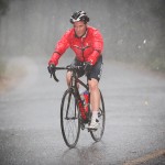
As I neared the hamlet of Jay, I started to notice a few ominous looking clouds in the distance (see photo at the top). I was heading right toward them but given I needed to take a left in Jay and head toward Wilmington I figured they’d pass me by and I’d be able to continue on unabated.

The 7km section from Jay to Wilmington is very much up and down and includes a 3km climb and a 2km climb. While the sky wasn’t looking any darker as I approached Wilmington, the wind had picked up a little and the temperature had dropped considerably. And then it started.
As I rode into Wilmington the first streaks of lightning lit up the sky, thunder rumbled overhead, the wind whipped itself into a frenzy and the rain started to belt down. I pulled off to the side of the road and sheltered under the verandah of a local motel, hoping the storm would pass so I could continue on and climb Whiteface Mountain.
I knew the climb was extremely exposed in parts, particularly at the top, so the idea of climbing it with lightning flashing around me was, well, unappealing to say the least.
I waited under that verandah for more than an hour. Just when it looked like the lightning had stopped and the rain had cleared, another flash would streak across the sky and it would start pouring again. It was a frustrating period but one that was improved significantly by an exchange with a gentleman staying at the motel.
Him: Where you from?
Me: Australia.
Him: Oh, beautiful country you got there!
Me: Oh yeah? You been?
Him: Oh no, but I seen it on the Sound of Music.
Me: Ah, I think you’re thinking of Austria?
Him: Oh.
It was one of the highlights of my US trip so far, for one simple reason: I’d heard that some Americans get Australia and Austria confused but I’d never believed it. The entertainment continued when the man’s wife told him, shocked, that I was planning on cycling up Whiteface Mountain. He turned to her and said sharply ‘Compared to where he’s from, Whiteface will be like riding up a small bump!’
While we do have some great mountains in Australia, I suspect they’re not what our country is known for here in the States. My feeling is that he might still have been a little confused about where I was from.

Eventually, with the rain cleared and the sky looking lightning-free I saddled up and headed toward the start of the climb. I’d heard there was a toll to climb Whiteface Mountain but also that if you waited until after 5.30pm the road is closed to traffic and free to climb. Having lost an hour due to bad weather, it was 5.00pm when I left Wilmington and it would be about 5.30pm by the time I reached tollbooth.
The climb starts as soon as you leave Wilmington and the gradient is immediately about 8%. For the first 5km to the tollbooth, the gradient barely changes and it simply becomes a case of finding a rhythm. Despite having cooled right down after an hour’s break, I found the climbing pretty comfortable and was able to churn through the kilometres easily.
As I neared the tollbooth, I noticed a ‘road closed’ sign on the boomgate and went to ride around it. As I did, a woman in the tollbooth called me over. Turns out the road wasn’t closed because it was the end of the day; rather the whole mountain was closed due to the bad weather.
She suggested that if I waited until 6.45pm (an hour an 15 minutes away) when she left for the night, she wouldn’t know any different. While it was somewhat tempting to wait, it was already starting to get dark and a few specs of rain were starting to fall. After a brief moment’s thought I decided to head back down the mountain.
I bombed down the 5km to Wilmington, disappointed I hadn’t been able to get to the top but promising myself I’d come back the following day and have another go. In the end it was a good thing I didn’t ride to the summit.

A few kilometres out of Wilmington, on the way back to Lake Placid, the heavens opened once more. Now, I’m not talking about some light shower, I’m talking about the sort of rain that leaves you absolutely soaked through in less than 30 seconds. If Strava plotted rider morale over time you would have seen mine drop off a cliff as that storm hit. I was ridiculously wet, it was starting to get very dark and I still had 15km of mostly uphill riding to go.
Oh, and remember that lovely tailwind on the way from Keene to Jay? Of course, that was now a strong headwind, just to add to the fun. But perhaps the lowest point came as I reached a fork in the road about 69km into the ride. I had no map to work out which way to go, I was cold and wet, it was getting very dark and I had no lights. In the end it came down to a guess.
For five horrible kilometres I had no idea if I was going the right way or if I was heading deep into the Adirondack wilderness as darkness was falling. It wasn’t fun. But, after 5km including a frustrating kilometre-long climb with the wind blowing rain into my face, I reached a crest and saw one of the most welcome signs I’ve ever seen: ‘Welcome to Lake Placid’. What a relief.
By the time I got back to the hostel I’d ridden 76km and climbed about 1,000 vertical metres. A reasonable effort but my main objective wasn’t complete — I still needed to climb Whiteface Mountain.
Route: Lake Placid to Whiteface Mountain, return
Distance: 70km
Duration: 3 hours 5 minutes

The next morning I wasted no time getting up, out of the hostel and on the road. It had rained most of the night but when I started riding the weather couldn’t have been better — high 20s, clear blue sky and only a little bit of wind.
As with the previous day’s ride, the opening kilometres were fast, pleasant and among the most enjoyable of the day. I wasn’t taking any chances with the weather — I was heading straight from Lake Placid to Wilmington and then up the climb to Whiteface Mountain. With no rain to speak of, I actually had a chance to enjoy the scenery, and there was plenty to enjoy. The road follows the curves of the Ausable River and as you get closer to Wilmington, the views of Whiteface Mountain become ever more impressive.
At Wilmington I turned left and got stuck straight into the climb. I knew what to expect of the first 5km and so I just focused on finding a rhythm and ticking off the kilometres. By this time it was getting pretty hot and so I took the opportunity to take off my helmet. I’ve ridden helmetless a few times before, but only on ultra-quiet climbs and only for a few minutes at a time. But on Whiteface Mountain, I rode virtually the whole thing with my helmet off. Despite it being perfectly legal here in the States and the fact I wasn’t going any faster than 11km/h, it was still a pretty strange feeling.

As I reached the tollbooth for the second time in two days, I looked for a sign saying ‘road closed’ and thankfully found none. I stopped for about 30 seconds to pay the toll ($6 for cyclists), and then continued.
I’ve ridden few climbs where the gradient is as steady as it is on Whiteface Mountain. From the moment you start climbing in Wilmington the gradient settles at about 8% and really doesn’t deviate from that at all. There are literally only two spots on the entire climb where the road is flatter than that — one at the tollbooth where the road is flat for a few hundred metres, and one about 2km from the top where the gradient drops to about 4% for a while.
From the tollbooth it was all about getting settled back in and finding a comfortable rhythm again for the remaining 8km to the top. A few kilometres beyond the tollbooth the road emerges from the trees and you start getting some terrific views out to the north west. The views aren’t consistent though — you’ll ride for a kilometre or two through the trees and then you’ll get another glimpse of the valley.
Then you’ll be back in the trees and you’ll have to wait a few more kilometres for the next view. I found these little rewards really helpful in breaking up a climb that more or less consists of two, long, straight sections of road.

As I climbed higher the views got better and better. I was feeling strong and I knew I’d be able to finish, I just had to keep on going. As mentioned above, the road flattens off briefly a few kilometres from the top and at this point I took the opportunity to flick through the gears and build up a bit of speed. I could see the castle at the top of the mountain by this point and I knew I didn’t have far to go.
Eventually, after 1 hour and 8 minutes of climbing, I reached the top of the 13km climb. It was a tremendous feeling, particularly given the disappointment of the day before. I hope the pictures included here give you some sense of just how spectacular the views were. I particularly liked being able to look down on the road snaking its way up the mountain, knowing I’d just dragged myself up it. Very satisfying.

After taking a few photos I decided to head up to the castle at the very top of the mountain. The steep, half-mile (800m) hike didn’t seem all that appealing in cleated shoes, so I opted for the cooler option. Give me a moment to explain.
The road up to and castle atop Whiteface Mountain were officially opened in 1935, having been built as a memorial to World War I veterans. Then-president, Franklin D. Roosevelt, was apparently in a wheelchair at the time the castle was completed, meaning the steep, rough path to the top wouldn’t be suitable when the president arrived for the official opening. Instead, engineers built a 130m-long tunnel and 27-story-high elevator inside the mountain, the excavation of which apparently required 22 freight train cars full of explosives. Apparently they dug the elevator shaft from the bottom up but I have no idea how that would even work.
With a bit of cloud hovering between the top of the road and the castle, the views from the summit weren’t any better than below. Still, it was cool to learn a bit about the history of the place and to get to the very top of the mountain.

The descent of Whiteface Mountain was one of the fastest I’ve ever done. With the steady, steep gradient it was easy to build up a bunch of speed and, with very few corners to navigate, I spent a lot of the descent at 70km/h+ (not Pro-Tour-fast, but fast for this hack cyclist!). On the way up I’d seen a bunch of signs saying ‘rough road’ but you don’t tend to notice the road surface too much when you’re climbing at 11km/h. On the way down though, it was a totally different story.
The road is covered in little bumps, not-so-little bumps, corrugated sections and some huge potholes as well. I had a couple of hairy moments as I came up to potholes at speed without seeing them and on many occasions I had to bunny-hop my way across sections of broken road at 60km/h+.

Once back at Wilmington I paused long enough to take off my jacket before continuing on my way back to Lake Placid. I knew the return was going to be a slow grind and that’s exactly what it turned out to be. The wind was blowing in the same direction as the previous day (which would explain the easy start to the day) and, the road being largely uphill, I had to be content with spending a lot of my time at about 20km/h.
But, overall, it was certainly a far more enjoyable end to the ride than I’d had the day before and, like the start of the ride, I was able to appreciate the natural beauty of the high peaks region. It’s a shame that I wasn’t able to get in more riding while I was up there. If I’m ever in the US again with the chance to ride, I’ll be back to the Adirondacks that’s for sure.

I’m glad I made the effort to get to Lake Placid and climb Whiteface Mountain. It was one of the most enjoyable climbs I’ve done in a long while and after the false-start the day before, my satisfaction at reaching the top was even greater than it might have been. After the Mt. Baldy experience, it was such a delight to be able to get through a climb again without having to stop!
Thanks again to Brian and his team at High Peaks Cyclery for looking after me and for helping me to conquer the great mountain. And thanks to all of you for reading and following my travels in the US. I’ll be home in about a week’s time but before then, I’ve got some more great climbing planned.
Stay posted.


More from The Climbing Cyclist
 December 20, 2012 7 Peaks Domestique Series rides #3&4: Mt. Buller
 August 26, 2015 Four reasons to take time off the bike over winter
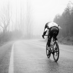 November 19, 2014 Domestique 7 Peaks Series 2014/15: Lake Mountain
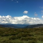 January 9, 2012 Episode 9: backing up with the Back of Falls
 November 19, 2011 Episode 1: the Great Ocean Road ride
I know its been a while but do you recall the gearing you used?
Thanks for sharing Matt, it has been great to live through your US adventure
Thanks Geoff!
Enjoying your amazing adventure. Good thing its after you have done your rides. Great photos. Will you be sacking your two climbing photographers when you return to vic .
Thanks Skettie! I can’t take any credit for the pics – the scenery is so good that it’s hard to take a bad photo! See you soon!
Terrific write-up and well done on the climb! The Sound of Music reference is both hilarious and embarrassing, yet not altogether surprising. Many of my neighors are not up on their world geography.
This one is also on my bucket list. Looks like a gorgeous climb. The snaking road reminds me of a lot of the Euro Tour climbs, which I have not seen many of in the states.
What an adventure you are having!
Enjoy the reading and the breathtaking picture, what an achievement!
Like the humour site of the confusion part between Australia and Austria, but I can relate that, since myself one stage got confused on the location in my Geographic exam, and the name in my English exam, mind you that was before I physically arrived in Australia, then had clear realisation that they were different counties in different continents, more importantly – different hemispheres on earth.
one of your best write ups yet, Matt, so enjoyed reading it and looking at the photos, captured the flavour of the ride brilliantly!
Thanks very much Deb. 🙂