

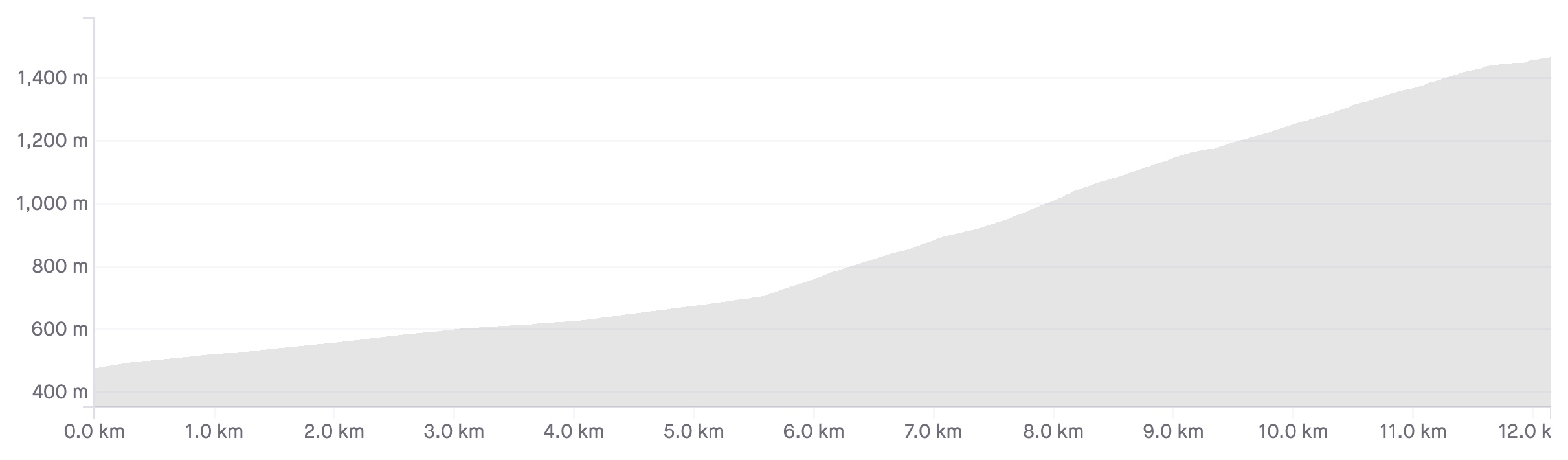
Length: 12.5km
Average gradient: 7.7%
Elevation gain: 962m
Introduction
Ranked among the hardest road climbs in Australia, the ascent of Mt. Baw Baw presents a challenge for cyclists of all abilities. The first half of the climb is friendly enough but at an average gradient of over 10%, the second half of this climb is not for the faint of heart!
The start
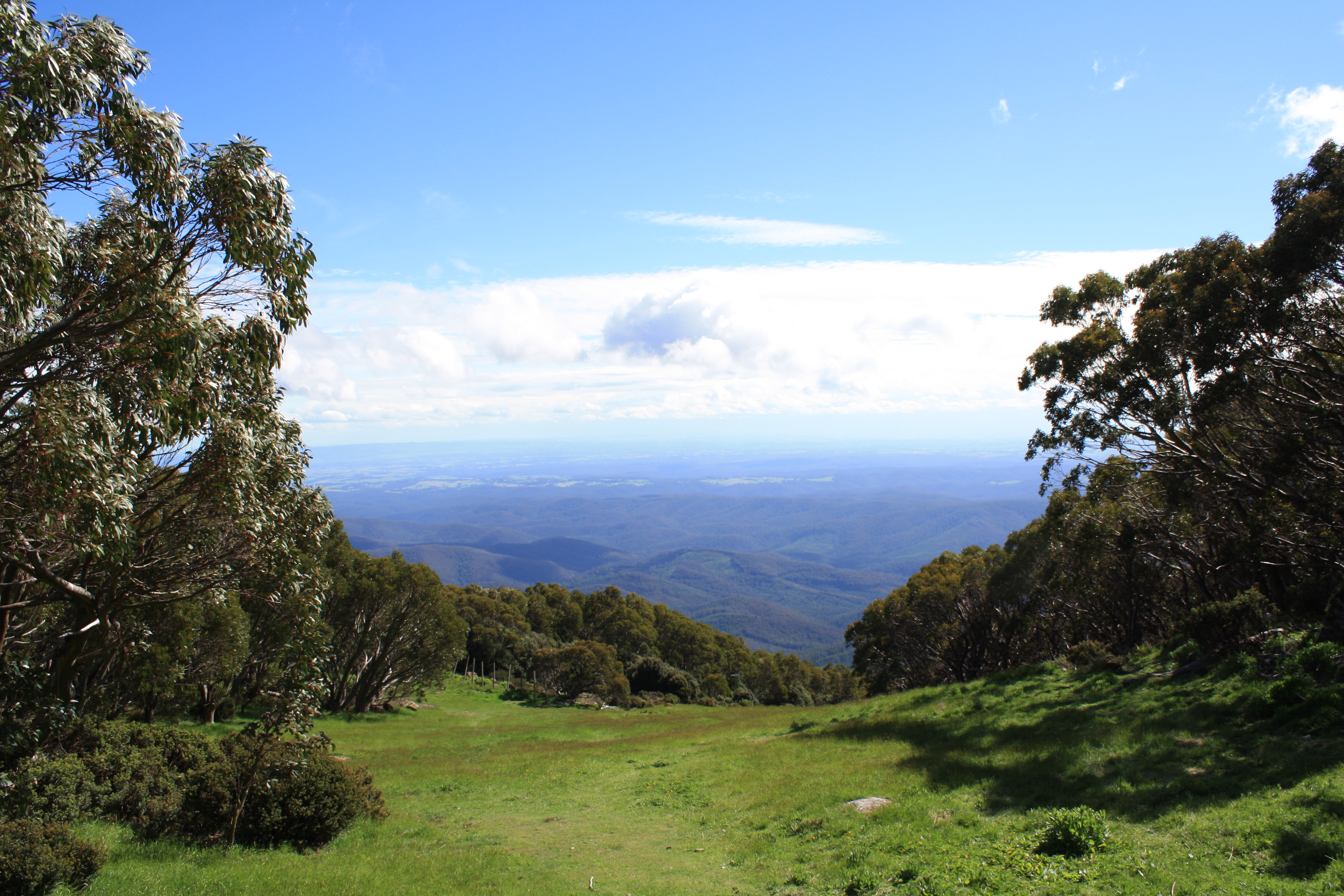
The ascent of Mt. Baw Baw begins where the Mt. Baw Baw Tourist Road (C426) crosses Big Tree Creek the Tanjil River East Branch for the first time, around 3km south east of Tanjil Bren.
(February 2022 update: apparently the sign in the image below now reads “Tanjil River East Branch” rather than “Big Tree Creek”)

The finish
The Mt. Baw Baw climb concludes at the entrance to the Mt. Baw Baw Alpine Resort.

At a glance
- A seriously tough climb with one of the steepest, sustained sections of climbing in the state.
- The first 5.7km of climbing are quite gentle at an average gradient of 4.2%.
- From The Gantry to the summit it’s 6.5km at an average gradient of 11.5%.
- Take a left turn at the 7.5km mark to continue the climb.
- The steepest part of the climb is Winch Corner — a short 20% rise 8.3km from the start.
- After The Gantry, the gradient only drops below 5% at the left turn at 7.5km and at 9.6km.
- The final 700m of the climb are noticeably easier than the previous 6km.
Climb details
A warning to recreational riders – this is a seriously challenging climb and one that should not be attempted unless climbs like Lake Mountain and Inverness Road can be completed without too many difficulties. Treat this climb with the respect that it deserves!
After crossing Big Tree Creek, the road remains flat for 200 metres before crossing the creek once again and it’s at this point that the climbing starts, settling into a comfortable gradient of around 5%. At the 500m mark the gradient increases slightly, sitting at around 7% before dropping back to 5% a short time later. A gradient of this intensity is maintained for most of the climb’s first half, acting as a mere appetiser for the epic second half.
After 1km of climbing the road bends sharply around to the left before heading back around to the right shortly after. At the 1.5km mark the gradient increases slightly again as the road bends around to the left and then sharply around to the right 100m later. Passing through a dense covering of native ferns and eucalypts, the road flattens out at the 2.4km mark as it bends into a right-hand hairpin.
After several kilometres spent winding through the lush beauty of the Baw Baw National Park, you’ll notice that the road increases in gradient at the 4.2km mark. By the 5.0km mark the road has flattened off quite noticeably and as you bends sharply around to the right, the road becomes completely flat. After returning to a gradient of 4% a few hundred metres later, the road continues to wind its way toward the business end of the climb.
After 5.7km of climbing you will notice a sign on the left of the road announcing that you’ve reached The Gantry. This point marks the end of the pedestrian climbing and the start of 6.8km of pain and suffering. As you bend around to the right and past the site of the old tollbooth, you’ll see the road disappearing skyward in front of you – a sight that continues to scare even the hardiest of cyclists.
From this point it’s all up, and not gently either. Straight away the road settles into a gradient in excess of 10% which is more or less maintained until the end of the climb. You’ll want to find a rhythm pretty early on here as it doesn’t get a whole lot easier from this point.
300m from the start of the steep section the gradient is still holding at above 10%. At the 6.2km mark the gradient increases even further to around 13% before bending sharply around to the left 100m later. Another 100m up the road and the gradient has eased to a comparatively casual 9% but it doesn’t last long with double-figure gradients being reached after another 100m.
At the 6.7km mark the road bends around to the left at a painfully steep incline but 200m later the pain eases slightly as the gradient drops below 10% again. At Neulynes Hill, 7.0km from the start of the climb, the Mt. Baw Baw Tourist Road presents you with a painful 500m slog with the gradient hovering around 13%.
At the 7.5km mark, you’ll need to take a left-hand turn to follow the C426 toward the summit. As you turn the corner, you’ll noticed the road flattening out to comparatively pedestrian 4% for all of 50m before the road bends right and back towards gradients of greater than 10%.
After another 800m slog the climb reaches its steepest point, the aptly named Winch Corner, which reportedly maxes out at a gradient of 20%. It’s an incredibly steep left-hander that flattens out to around 14% as it straightens out briefly before bending toward the right and dropping further to around 10% gradient. At the 8.6km mark the gradient is up around the 15% mark again as the road bends left but then, 100m later, it flattens off to around 7%.
Over the next 300m the gradient increases gradually until, at the 9.0km mark, you’re in 10%-plus territory again. Over the next 600m the gradient fluctuates slightly, but never drops below around 8% as the road winds steadily toward the summit. At the 9.6km mark though, the road has flattened off completely and even heads downhill for all of 10m. No sooner has the false-flat started than the road is heading skyward again, in excess of 10%.
At the 10.3km mark the road flattens out briefly before kicking up again, hovering at around 10% gradient for the next 1.5km. At the 11.8km mark the road flattens out for the final time, passing a number of car parks and ski lodges on its way to the entrance to the Mt. Baw Baw Alpine Resort and the end of the climb, 700m later.
Profile
Location
The Mt. Baw Baw Alpine Resort lies around 150km east of Melbourne and around 50km north east of the township of Noojee along the Mt. Baw Baw Tourist Road (C426). Getting to Mt. Baw Baw from Melbourne can be achieved two ways, either by following the Princes Freeway (M1) past Pakenham and turning left just before Warragul or by taking the Maroondah Highway, the Warburton Highway and then the Yarra Junction-Noojee Road.
Mt. Baw Baw is not a climb that can be attemped without a suitable warm-up and good starting points include Icy Creek (~70km round trip) and Noojee (~100km round trip).
Times
As if climbing this monster of a mountain wasn’t enough, there are those that feel the need to punish themselves further by racing against the clock.
A Strava segment for the whole climb can be found here. The final 6.5km of the climb has its own segment too.
Well I have finally tackled the beast today.
I have been looking at your description of the climb for months.
I have to say a compact crank really would have been much easier than the 53/39 I’m running, however I grounded it out.
As soon as the road points upwards, you know you are in for a battle.
It just never seems to end, once you turn at the chain fitting point omg. I looked up and laughed thinking am I going to get up that?
The sign half way up that straight inducting your climbing at 21% is enough to brake your hart, the enormity of the gradient in your mind is enough to shake you to your core.
At this point is when the gremlins creep into your mind, telling you you’re not going to get there.
To make things worse after all that climbing at around 700 metres away from the end, I realized I was climbing with a flat rear wheel ????.
I can’t believe I finished it.
I’m glad you have this article describing this monolithic climb.
It’s by far the hardest ride I’ve ever taken on.
Thanks Matt.
Congrats Chelsea, awesome effort! It’s such a brutal climb!
I took on Baw Baw for the first time yesterday.
For the last few weeks I’d been wanting to tick this off my list. Even though I’d climbed Lake Mountain, Donna and even a 4xInverness without much hassle, I was nervous as hell and doubting my 36/30 would be enough.
Glad to say I got through Baw Baw in around 65 minutes, the roads are in good condition at the moment but definitely recommend taking your time on the descent.
Thanks for all your write ups Matt, a goal for me this year is to make a first climb or set a new PB on all 35 of the Vic Climbs. Your page is a great resource.
Thank you for your amazing and accurate insights into the Alpine peaks and beyond. I completed Baw Baw last year as the last of my Seven Peaks rides for 20/21 season.
I am an average 60 year old cyclist with minimal competitiveness but loads of determination to complete any challenges that I set my mind to. I stated at Tanjil Bren and enjoyed the first 6+ kms of the climb as a good warm up for what was to come. The final 6 kms were very challenging. The Gantry was an absolutely eye watering beast, completed only as getting off was too challenging. I did a lot of weaving to manage some of the steeper parts and had to be careful not to pull up on the handlebars on the steeper parts as you can easily flip your bike. I did allow myself to stop on two occasions to refuel as I found it impossible to do so while I rode. The March flies were plentiful and this kept my breaks short. At my slowest point I was travelling at 4kms per hour (Gantry) I didn’t know it was possible to go that slow. Reached the top at 11am to the massive high of having completed such a challenging climb and to having completed the seven peaks for the first time.
I rode this last Thursday April 11. I was looking for a hill climb doable from Melbourne as a day trip. I’d heard about Baw Baw but didn’t realise it was so revered until googling it and coming across you fantastic website! My eyes lit up! It’s VIC’s hardest climb and an easy day trip from Werribee! I hadn’t done a decent climb for a while so made the mistake of not checking my bike over apart from putting air in the tires. As I was only interested in the climb I started from the bridge down the hill from Tanjil Bren. The first half is very nice and thankfully I had an idea what I was in for so I took it really easy. Once hitting the Gantry I wasn’t overawed initially however that soon changed once I hooked in. It is brutal and the sort of experience that makes you say to yourself that you’d never do it again when you’re riding it but within days want to do it again ( can’t explain that)! What made it hard was I was never able to engage the inside sprocket on the front chain set meaning I rode the entire climb with 53 / 25 gearing. This meant I did have to zig zag but was able to use the sides of the road as a bit of a ramp to get some momentum.
I have no idea of my time I was just happy to get to the top. I really enjoyed the clean autumn mountain air however coming down was freezing and I missed out on the summit view due to to fog. The climb is both a physical and mental challenge. I found that I had to lie to myself a few times and break the climb down into segments and not look up too many times as it’s so demoralising. That said it’s a great feeling getting to the top. Be careful on the descent!!
First, thank you for a very informative website. It’s inspired me to seek out mountains in both NSW and Victoria. A glutton for punishment, you might say. But how special is it, to savour these quiet, intense, magnificent places at a pace that let’s you feel the mountain and soak in the bush.
My turn to submit myself to the merciless hand of Baw Baw came today, a sunny, quiet Friday in autumn. I was en-route from Melbourne to Bairnsdale with my wife, so I opted for a short run-in starting at Icy Creek. First thing to note – there is nothing by way of public services at Icy Creek. The single facility, a toilet block, was closed. There weren’t even any people to be seen. Just two quiet, possibly unoccupied houses, and some horses. It made me wonder why it had its own name, as though it was a centre of human habitation and activity.
We had stopped earlier at Noojee for lunch and it would be a much better starting point from the point of view of services, with a pub, two shops, public toilets and a nice riverside park with picnic tables and shelter. Oh, and another 15k of “rollers”. For Sydney people, like me, these rollers are at least as big and hard as the biggest climbs in the Sydney metro area (eg, Gorges, Akuna, RNP). Mostly bigger, I think, although I wasn’t measuring them.
So starting at the aforementioned Icy Creek, I passed pretty easily over 20 km of rollers leading to the beast itself, lying in wait. The roads were clean and there was almost no traffic, and riding the climbs easily and cruising the descents made for a nice start.
But said beast appeared soon enough. I decided to employ a steady approach to the first stanza, to reserve energy for the 2nd. It continued to be very quiet, in fact, there were no other cyclists and only a handful of motor vehicles in the 2 hours that I was on the road. I enjoyed the solitude and it helped me to appreciate the beautiful bush and sinuous curves of the easier first half.
The second half was an unrelenting grind. It just goes on and on and on. I soon found out that I’d have done better to go even easier in the first part, as I wasn’t able to even sustain the same (tempo) power I had been putting out previously. Whether it was just me or it was the effect of extended climbing with no let-up, I’m not sure. Probably both. When I looked at my times afterwards, I’d fallen back a lot further compared to my age cohort in the second half than the first.
The effort of sustained low cadence grinding is wearing. The required focus means you don’t get to enjoy the magnificence of your surrounds. The attention is on your heart rate, your breathing, the motion of the bike as you sway your way upwards, the sweat falling from your forehead, the pain in your legs and so on. It becomes a very small world. I find it’s better that way, especially when it’s the first time up a climb. Treating each visible segment as its own challenge, staying in the moment, helps to make the task feel attainable. Just get to the next corner, up the next rise, through the next 500 metres and so on.
I did find it was possible to get into a rhythm. My low gear was 36/32. I changed up a few times briefly, either to relieve my legs by standing for a while, or to take advantage of the very short shallower gradient sections. I also found myself using the granny gear for some of the standing – for example, in the 20% corner mentioned in the article.
Eventually, the top arrived. I felt that I should be sprinting through the gate posts, but there wasn’t that much gas left in the tank. A dead man’s sprint, it was. It was nice to be able to go to the cafe and refuel while looking at the view. On reflection, I felt satisfied with my effort and very pleased that I’d been able to experience a particularly demanding, beautiful and worthwhile climb. I recommend it to anyone who’s up for a challenge.
Rode this today and it was every bit as hard as I thought. There are 3 options for parking, Neerim South, Noojee and Tanjil Bren. All have parking and toilets.
Leaving from Neerim South involved riding on roads with 100 km/h speed zones and large logging trucks back and forth. I gave that a miss!
Leaving from Noojee was fine but be aware there is a lot of climbing before you get to the main Mt Baw Baw climb. If your unsure of your climbing abilities I would leave from Tanjil Bren and see how you go. It is a very beautiful ride through large forests, creeks and waterfalls.
The road was in great condition and seems to have been resurfaced. I got passed by only 3 cars in 5 hours of riding – the benefits of going mid week.
Also be aware that there is no drinkable water at Tanjil Bren so you need to re-fill at the top of Baw Baw to make it all the way back.
There is only 6 k’s of really hard riding right at the end and I mean really hard. My Garmin recorded a speed of 1.1 km/h at one point. At least I was still moving!
If you are climbing this over a weekend be careful as the road is really narrow.
This was a very tough afternoon out. I decided to start at Neerim South yesterday and it was a 130km round trip, taking 6hrs with 3100m of climbing. Don’t be fooled by the 12.5km climb, because there is climbing all the way from Neerim South. I saw images of 24% on my Garmin on certain pinches of the climb. Be prepared.
Rode this brute yesterday afternoon. Great ride but beware the really poor condition of the road (especially on the descent) as it has been resurfaced in the last week and there is a lot of loose bitumen on the road almost the entire climb.
Suggest opening brake calipers entirely to reduce risk of gravel getting caught in between rim and brakes and impacting climbing momentum.
Rode this brute yesterday afternoon. Great ride but beware the really poor condition of the road (especially on the descent) as it has surfaced in the last week and there is a lot of loose bitumen on the road almost the entire climb.
Suggest opening brake calipers entirely to reduce risk of gravel getting caught in between rim and brakes and impacting climbing momentum.
Tackled the beast today for the third time, leaving from Noojee. The persistent rain for the entire ride made a tough ride even tougher! Anybody looking to head to Baw Baw soon should be aware that the roads are in by far the worst condition I’ve seen them, particularly the section between Icy Creek and Tanjil Bren which is full of potholes. I almost crashed twice on the ride back to Noojee thanks to potholes that couldn’t be seen in the rain. Anyone heading to Baw Baw in the wet take extra care!
Hi folk,
I’d like to say thank you very much for having such a great website.
After doing 3 peaks last year and finding this site I made it a thing to come do Baw Baw today. The fact it was my first and I still need fresh legs for Sunday (what are fresh legs ) I tackled this and had my coach in my head saying pace yourself!
Well that I did and I went great, the weather was very nice, not to hot. So off I went, speaking to locals I heard it was a monster….. Well, nah it’s not! You need to enjoy hills and do lots of it’s your thing. The fact I paced myself on not going over 300w helped heaps.
The respect I have for this climb will never fade, but will be back next year and smash it.
Thanks again for your guys work and see you did a great peice on my local training grounds in the port hills ChCh NZ With Georges info.
If anybody has the chance to visit chch try the Port Levy climb, Bossu Rd and up the Long bay rd. I’m sure George will agree. All the best to everyone who tackles this and never get off your bike, just train harder!
As it is my intention to ride all 7 peaks four times this season, I rode up Mt Baw Baw twice on the 5 February and twice again the following day from the Gantry. Weather for riding was ideal although by late morning on the 6 Feb it was getting a bit on the warm side. Three of the ascents of Mt Baw Baw were on my Jamis flat bar road bike and one was on my 40 year old Peugeot.
My times for Mt Baw Baw are not very impressive as I am 69 years of age. However, I am generally able to ascend without stopping but sometimes it is wiser to get off the bike before having a fall because of the slow speed especially at Winches Corner.
I now have only to do Mt Hotham, Dinner Plain once more and Mt Buffalo and Falls Creek twice to complete my mission.
There’s no way on this earth that Mount Macedon (Gisborne side) is harder than Baw Baw…even Alton Road at Mount Macedon is easier than Baw Baw
As an avid reader of this site, there is not much that can prepare you for this climb but it was nice to read about it first. It isn’t impossible but it is tough. I started from Tanjil Bren this morning with light drizzle and initially poor visibility which meant I couldn’t see too far ahead. This helped as the climb only presented itself 50m in advance which was good for my motivation!
The turn off just before winch corner was above the clouds so the second half showed itself with full brutality. I found a gear and a rhythm, enjoyed the scenery and the total lack of cars or other people and settled in.
Beautiful climb, nice coffee at the top but just be careful coming back down as the road is a bit of a mess.
Rode up Baw Baw for the first time last Saturday. First 5.7 km to the Gantry took 22 minutes, second 6.5 km took 40 mintues. I was expecting a lot worse! I’d rate it easier than Terry’s Ave, and Mt. Macedon (Gisborne Side).
What a monster, I can’t think of anyone’s driveway from under the house being that steep. Rode from Noojee with a mate which was beautiful, until The Gantry. My Garmin kept “auto pausing” as I was going that slow. I told myself beforehand that I wasn’t going to zig zag my way up, but it just had to be done a number times if were to stay upright. I’d said to my mate that this will be the hardest ride we’ve ever done, and our expectations were met. Me 1, Baw Baw 0.
Today the 30th of March, 2014, just completed baw baw with my son in law, what a ride the 6 kilometres they talk about as you climb towards the summit is just gut renching, the first section of this climb makes you think why am I doing this, but it does get easier, once into the last three kilometres it starts to ease off, it was so good to see the stone walls, having done Buller the week before how easy is it, good to see a number of people doing this climb.
scummy just 60?
Rode Mt Baw Baw from the Gantry with another Shepparton BUG rider on Friday, 21 March without a warm up.
Despite rain threatening, it was dry with the temperature at Mt Baw Baw around 12-13 degrees. Although wind gusts up to 57 kph were recorded by the BoM at Mt Baw Baw we were shielded by the tree canopy during the ride.
This was my third Baw Baw ride and second this season. Unlike my two previous rides on my Jamis flat bar road bike I used my 39 year old Peugeot steel framed road bike this time. I have riden the 7 peaks twice this season including all seven on my Peugeot.
On all ascents of Mt Baw Baw I have found the Winch corner the most difficult which is not surprising given the grade is around 20.5%. On the latest climb I confess that I had to dismount at this point to avoid falling off the bike as I was going so slow I could not maintain control. After a short walk (50 m) I resumed the ascent without stopping.. Before starting the descent I discovered my front tyre was virtually flat. Clearly the the under inflated tyre would have hindered my ascent.
The descent was a bit scary as my brakes were not very effective. There was a lot of screeching of the brakes but I managed to get down without an incident. It may have been a different story if had been raining.
Rode Baw Baw from Icy Creek on Sunday 23rd March 14. Fourth time this season and by far the coldest. 12 degrees C at Icy Creek and much colder at the summit with fog, drizzle and visability down to 20 meters. Road from the gantry to the summit wet and quite slippery. A few other riders on the road so I was not the only one out. More cars than usual. Descent to the gantry was pretty chilly but had extra gear to wear. Fair amount of debris and stones on the descent to the gantry. So really take care coming down this section especially if wet and foggy. Had to change rear pads before descent as water on the rims was playing havoc with brake pads.
Countryside was still very green and sensational. A 72km round trip which I always enjoy. Hope to ride it one more time this autumn before the really bad weather sets in.
After training and worrying for 3 months, we finally faced Baw Baw on Sunday 15th December. Seven of us rode from Tanjil Bren and up the mountain – 3 men aged 36, 56 and 60 and 4 women, aged 40, 40, 52 and 55 (that’s me).
As you would expect, we two fifty something year old females brought up the rear. I had studied your description of the Baw Baw climb and broken it into short sections, to allow for short stops at the 1.8km and 3km points, in particular. (Distances are from the gantry). I must thank you for your detailed and extremely accurate descriptions and distances. Thanks to your breakdown I felt the task was achievable. The ride went to plan perfectly and we all made it to the top. Of the seven, we only have Buller & Dinner Plain to do.
Many thanks, Trace
Well we did it. Everything here was true about this brute. My wife and I, both 63 and started riding 3 years ago, completed it last Sunday in very ordinary weather. Drizzle most of the way up and freezing conditions descending. I needed two stops to get feeling back into my fingers. A broken rear spoke going down applied a little auto braking with a wobbly wheel which probably helped.
Anyhow, a great ride and along with this site, very satisfying.
Rode the beast on the weekend and it certainly lives up to it’s name!
Started in Noojee and the ride from there to the Gantry was very enjoyable with amazing scenery and mainly rolling hills…..but the view from the Gantry heading towards the the first section of plus 10% road was a sight to behold and the best way i could describe is it was it is like riding towards a bitumen version of a massive 10 metre wave!
The next 6 kms can only be described as a slow,sustainable and painfully unrelenting riding experience you will possibly ever have…but the joy you obtain from reaching the summit will override the any one of those initial feelings in one foul swoop.
I’ve only been riding the bike seriously for 2 years and would recommend this experience to anyone who is up for a serious challenge.
Great details Matt..
Easiest way to describe the climb as Matt said, Have to treat this with respect. Most challenging climb I’ve done so far.
in my case I had a bit of Cardio issues, it is a very good descend , yet have some derbies and damaged surface a bit.
Good luck and have a safe ride to everyone for the big day tomorrow.
Thanks for the explanation. Rode Mt Baw Baw for the first time yesterday. Relentless and tough is all I can say.
It was snowing when I got to the top so had the joy of having my teeth chatter on the way back down. 5 degrees back to Noojee felt warm after that.
Great website this is. 🙂
I rode my first Baw Baw climb yesterday starting from Noojee (49km’s from the top of Baw Baw). In my opinion that’s where the climb starts. Straight away one get’s presented with 4.5 km of climbing with sections going to 12%. From there on it is the whole way up and down with gradients between 1 to 7%.
Pleasant ride though through the dense forest, especially yesterday with the sun keeping me company.
First section of Baw Baw is easy enough but like the ride description here states, from The Gantry it is a different kettle of fish. I made it in one go to the chains bays but needed a rest. From there on it was a struggle counting down the meters. 10 Meters on those gradients can last an eternity.
Finally made it to the top and was served a nice piece of chocolate cake at the Village Restaurant where I also got my Seven Peaks stamp.
Downhill is a bit tricky and needs constant concentration.
No it wasn’t a perfect ride but at the age of 58, I am more than happy.
Keep up the good work!
Thanks Eddy! And congrats on conquering the beast that is Mt. Baw Baw!
I have ridden and raced this climb several times. Did the Noojee – Mt Baw Baw loop a week before the first Mt Baw Baw road race on 39 x 23 and made it around but felt somewhat buckled afterwards.
That Monday, I bought a 12-25 cassette and raced the next weekend on that without too many issues but it was pouring rain which made for a slippery and treacherous day. Many high quality climbers were stuck on the climb that day with only 39 x 21, zig zagging their way up, turning in circles on one spot or simply stopped with their heads hanging over their handlebars. The climb is tough enough but the ride from Warragul first simply tears you apart.
Hey Karl.
I’m heading out to climb Baw Baw again this coming Wednesday, 3/7/13.
Just after some knowledge on the road surface as you have climbed it very recently. Was there any ice/frost on the climb? And was it slippery or dangerous? I have been very diligent checking weather forecasts and there is no snow forecast between now and Wednesday and the Wed max temp will be 5 degrees, so I’m assuming the road conditions will remain similar to what there were for you.
Cheers mate,
Dave
Just completed Baw Baw today from Icy Creek (70ks in all). Probably not the best time of year as very cold but only few drops of rain. A truly awesome world class climb and certainly the last 6.7k tougher than any thing we completed in the Pyrenees, the Dolomites or Italian alps (although didn’t do Zoncalon when at the Giro in 2010–that looked really impossible).
I am 65 and rode with another 64 and 58 year old and we all made to the top…used a 34/28 on my Parlee. The descent was freezing and required a lot of care with the very steep wet road but a lovely ride back to Icy Creek once down the Mt. a bit.
A great training ride in preparation for our trip to the French Alps and the 100th Tour in July. If you’re in two minds about attempting it….JUST DO IT !!!
I was in two minds about attempting it… so I just did it (26/06/13). Thanks Scott. 🙂 . Luckily the weather was perfect and traffic pretty quiet as there’s hardly any snow yet, just enough for a bit of tobogganing. The scenery was absolutely magnificent but the road surface was a bit ordinary. I think it’s not too bad if your gearing is low enough (34/28) and you’re happy to take it easy, but would definitely hurt at pace. Requires a bit of core strength if you grind all the way.
Long time reader first time commentator. Tackled Baw Baw on ANZAC day leaving from noojee. It should be noted that the first climb out of Noojee is a real b#*ch, I felt that it was just a slightly shorter version of the wall. The rest of the ride to Baw Baw is truly spectacular although is nothing but descending and climbing for the rest of the 40km. In terms of the final 6ks of Baw Baw itself I didn’t actually find it too hard. I think this is because from reading your article and the subsequent comments I was absolutely terrified approaching the climb, believing that I would be in more pain than ever before. However after getting into a steady rhythm (that involved eating a block of chocolate as a reward for every km finished) and making use of the full width of the road by zig zagging my way up, i felt that it was manageable. Although still very much of a grind running a 39×27 and resulting in most of my time being spent out of the saddle. Lastly thanks Matt for all the info! Without this site I would never have gotten into climbing.
Can someone change 7 Peaks to be 6 Peaks and take Baw Baw out please? 🙂
Freezing cold even on the ascent. Lost count of how many times I stopped. But I did make it to the top!
Look – I’m not young nor that fit. When I was young and fit I weighed in at 75 ks (and just under 6′ tall). Now, after losing 10 ks – I’m still 95 big ones! How does a Fat Fossil Climb Baw Baw on a road bike? This is my manual of tips:
1/ get a bike with a compact crank;
2/ ride a lot and do other hills regularly;
3/ Make your attempt in favourable conditions – no rain, not too hot and a minimum of traffic. the lack of traffic is most important;
4/ And Give yourself permission to:
a) Stop a lot on the way up;
b) Take 4 hours to get there – if you need it;
c) Zig Zag – and Zig Zag with precision!
I attempted Baw Baw once before as I was close and doing the 7 peaks. (My First Real Hill!) I grinded up about a K as fast as I could; just about to stroke out(!) when I managed to get some road waste (branch) into my spokes – zapping a tube (lucky) and probably stopping myself from having a heart attack (lucky again). Could not be bothered changing the flat – I clunked down. beaten by Baw Baw.
Today I got to the top!
I practiced zig zagging on the gentle climb to The Gantry. This time I determined to get to the top as SLOWLY as possible. (I know the young uns will be puking by now in some disgust…)
I found I had grown somewhat stronger over the last few weeks as I knocked off more riding (in too high a gear) along with 5 other peaks of the 7 peak challenge.
Still, my power to weight is still not there.
So, as I was zig – and zagging – I got into a rhythm of almost stopping half way cross the road… Adding to the time I was taking…
Slowing it down and keeping something in reserve for the shockers that always seem to be found on these climbs.
I did not recognise where Winches Corner was. There were a couple of nastier bits and I had the strength to push my way past them – often straight up for short bursts.
Not every zig zag needs to climb!!
I found that climbing on the easiest edge was the way to go.
Any way, I got to the top in about an hour from The Gantry. Didn’t stop once and didn’t take four!
My heart rate wasn’t that big a deal as I crested the top and ironically found today’s climb a lot easier than Hotham. Which is ironic because Baw Baw is by far the hardest hill I’ve climbed.
My message is you can get there! Beat Baw Baw – even if you are kinda Fat and maybe a Fossil!
Be ultra careful of the traffic and do not attempt this hill if there is consistent traffic and your package of bike and fitness means you have to zig – and zag!
We rule the planet btw – us Fat Fossils. Know your place skinny climbers!
It’s been years since you posted this, but just gonna say from one fat bloke to another – I’m going to give this thing a crack because of you!
Just a huge thanks to Matt on his awesome ride description, it’s what got me up this ride. As a novice cyclist I thought I’d give Baw Baw a go, and am super happy that I made it to the summit. Not the best time, but huge personal satisfaction. I needed the ride breakdown to help me chunk the climb into bits and it worked perfectly. One to tick off my bucket list
After getting into cycling in January, I made climbing Baw Baw my goal of the summer. So, armed with the knowledge attained from the climbing cyclist, I set off for Noojee to give this monster a crack.
After departing Noojee I approached ‘Vesper Hill’, and after a mere 5km of cycling, you could be excused for feeling like this little climb was Mt Baw Baw! The ride from Noojee to Big Tree Creek would have to be one of the most picturesque and peaceful stretches of road on the planet. It’s absolutely beautiful and definitely my favourite road that I have cycled to date. Although it can be a little sketchy in patches, encountering more than the odd pothole, it is still an amazing ride and one that you could never get tired of.
Once I reached The Gantry and laid my eyes on what I thought was a vert skate ramp, I couldn’t help but just laugh. Big Tree Creek to The Gantry is a nice cruise and then all of a sudden; BANG! You encounter the monster. The next 6.8km is relentless. I had to have another chuckle when I hit Winch Corner and had to switch off my auto pause function, as it was set to less than 3km/h! Although the climb is brutal, I still found it to be a great experience and reaching the top is an incredible feeling. Being a novice cyclist and weighing 84kg, I said to myself that any time under an hour would be a solid effort. I completed the final 6.8km in 48:50 and although that isn’t red hot, I was still pleased with my efforts.
To reiterate the thoughts of many others, the descent is not really that fun. You really need to be switched on. Visibility is difficult with the sun coming through the trees and the corners seem to be up on you before you know it. I could actually smell my brakes. Very, very fast.
All in all though, the return trip from Noojee is brilliant and I’ll be heading back very soon to try and knock some time off my first effort.
Cheers,
Dave
Hey Matt,
I did Baw Baw today for the first (only??!!) time with your 7 Peaks group (from Icy Creek). The reports of its brutality were not exaggerated! What a monster. Doubt I could have done it without my new compact cranks – 34×27. I was slow (57 minutes from the Gantry), but happy as a 48yo to complete the climb without having to stop.
Thanks for organising the ride and your great website.
Paul
Thanks for this Paul, and well done for conquering the mountain! 🙂
matt, i am 60 years young, and have just done buffalo, falls , hotham from harrietville and omeo, buller and am going to tackle lake mountain and baw baw on the weekend of 23 rd of feb weather permitting. i have found buffalo the hardest, possibly not enough carbs! baw baw has got me nervous, should i change over to my compact? is it like the last rise up hotham but 6 times longer? have you ridden the back of falls from the omeo highway? i did that without a compact and that was a grind fest, with a lot of self cursing most of the way. however, for some odd reason i prefer climbing than the flat. you should organise a tour to france, galbier, telegraph, alps du heuz, it would be a blast, but hurry before i get to old!
Hi Shaun,
Nice comment, thanks! Baw Baw is steeper than the Back of Falls … for nearly 7km. It’s like CRB Hill on Hotham, for 7km. 😉 So yep, compact is the way to go. And France sounds awesome! 😀
Thanks for the info. Great site! Mentally prepared me for the Baw Baw climb starting from Noojee yesterday. I was concerned about my gearing but do mostly climbing. Grinded out on a 39/25. Not ideal gearing for it was pretty tough to maintain any sort of rhythm but doable. Was happy with my first attemp of 42:24. Will be modifying my gearing for my next attempt and try and give it a nudge now that I know the climb. Thanks again!
Hi Matt,
Awesome site. Well done.
Conquered this beast today on a 39 x 27 after starting from Icy Creek. Wow what an awesome ride? Would have much preferred a compact crank but still got to the top. I think once you get past winch corner it gets slightly easier, but it’s still brutal. Provided you pace yourself early and get into a rhythm you can make it to the top. Am keen to get back and have and have another crack and beat my time from today.
Be careful of the potholes in the road. Very nasty. Especially from Icy Creek to the base of the ride. Not the best surface I’ve ridden on.
A tip from cyclingtips – “Try to attack the climb and it will attack you”.
Hi Matt,
After buying a new bike a few months ago, I decided to set myself a training goal. In a fit of madness I signed up for the 3 peaks! And then got my hands on a 7 peaks passport. I regularly read The Climbing Cyclist website and use all the data you have gathered to plan rides and trips. Many thanks. Commitments in Melb over Xmas / New Year prevented me from heading up to the high country to join your training rides. But Ive been doing my own thing closer to home, and on Friday tackled Baw Baw. More to the point, it tackled me. What a grindfest! I defy anyone to show me a 6km + steeper section for road bike riders. I have ridden in Europe a couple of times and dont recall anything as tough (tho I havent yet ridden Ventoux…..thats for July 2013). Sure, there are much longer rides with greater elevation gains around, but that short 6km+ is a serious test requiring not only strength, but concentration. But I got the stamp in the passport! We started at Icy Creek, home of the Icy Creek Music Festival mind you, and the 24km odd ride from there to The Gantry alone is stunning in its own right. I might see you out on the road sometime. Cheers
Great stuff Phil, well done! Glad you’ve got some use out of the site. Tell your friends! 😉
“I defy anyone to show me a 6km + steeper section for road bike riders. ”
Mortirolo in Italy. http://www.climbbybike.com/profile.asp?Climbprofile=Mortirolo&MountainID=12
Hey, did Baw Baw on Saturday 22nd Dec. What a cracker of a day. I started and finished in Trafalgar. About 164km all up. From Traf to Willow Grove, Hill End and onto the main Noojee/Baw Baw Road. Big day, just under 7 hours all up.
Basically from Trafalgar to the gantry, its a sweet ride, nothing to tough. Never rode up Baw Baw before but heard a few rumours…..When I hit the Gantry I thought I would push it hard until I bummed out. Well 1km later I was knackered and it was a matter of survival to the top. I stopped once because I thought I was going to pass out. Once at the top I promised myself I am never to do that again. By the time I got home I was trying to work out when I am doing that next!!
A few comments on the ride:
– The climb is brutal. I don’t know what gearing I’ve got but it didn’t seem enough. I’ll check it out
– The descent is even more brutal. I was just waiting for a brake cable to snap. Look out for potholes in the shadows.
– Have lunch at the top. Yum Yum.
– The climb is 90% mental, 10% physical.
Get out there and do it!!
Did the ride on 23-12-12. It was hot and steep – started from Noojee and went up to the top. Awesome ride, but very hard using 39T/28T combo.
Hot? It was so hot at the top, my tyres were sticking to the asphalt -as were my bike shoes, my thongs and anything else that touched the ground!!!
Views were brilliant – give it a go and claim your manhood!
Andrew – I’m guessing that was you topping out on Vespers as I began descending ! My only thought was “he’s gonna be hot !” Glad to see you made it. My ride was a lot cooler – starting at 5.50am was magnificent the whole way.
Matt – took your ‘tip’ about camping at Toorongo the night before the ride. Wife and kids loved it (kids first time in a tent), and it made the whole early start thing so much easier.
And of course, what an amazing road + climb. Best road I’ve ever ridden.
Hi Luke – quite probable. I hit the top around 11.40am. Could not believe how bad the asphalt was up on top. It was actually blistering – I heard the popping as I rode across the top car park – and my slick tyres very quickly became knobbies!
Hi All,
I’m doing the Baw Baw ride on Saturday 22nd Dec. Hope to start from Noojee at 9am. I am running 39/28 and am keen to use this as a training run.
please contact me at engo@infoxchange.net.au if you wish to join me.
As a guide, I generally do triathlons and my long rides are over/around the Dandenongs.
Cheers!
Well Done Joe
I did it Saturday from the Icy Creek and return 60 kms 3hours 30mins
I think you did it tougher than me i had a 34 x 27 as im doing the 7 peaks.
I have done some overseas climbs the petit st benard, col de madelaine,alp duhez earlier this year.I did it tough on a triple chainring in France.
That 6 km section is the toughest, steepest most unrelenting i have seen and climbed successfully. I did the last 6kms in about 58 mins 10 mins slower than my friends. I was doing some zigzagging as well whatever it takes as long as you made it through all the potholes/ fallen trees etc and then safely back down the mountain with the brakes on hoping for no punctures or the brakes to fail………..well we wont forget that one eh !!
cheers Karl
Thanks for the encouraging words, Karl.
I don’t know the total time for the return trip from Noojee to Baw Baw. I think I accidentally zeroed the stopwatch/odometer at some point from Noojee to the base of Baw Baw. But the final 62 km took about 3 hours and 43 minutes.
And, hey, I just checked my brake pads – I need a new set!
I did Mt Baw Baw today. Or should I say, Mt Baw Baw did me. I did the Noojee return (just over 100km). The ride from Noojee to the base of the mountain has been described here as a recreational ride, but I found that big hill near the start a bit of a challenge.
As for Baw Baw itself, the first 5 km took 21 minutes. The next 3 km took 23 minutes. And the last 4 km took 45 minutes! – because the only way I could make it to the top from there was to zig-zag my way up. I almost gave up at that point but someone passed me as I was about head back down and suggested zig-zagging might get me there. It did, but it completely zapped me of energy and wondered how I was ever going to get back to Noojee.
Actually, the trip back turned out to be a little easier than I thought, but it still took 2:13:45, including the 29 minute descent. I’m thinking the Three peaks is probably beyond me, though I haven’t thought about whether different gear ratios and crank sizes would make much of a difference.
Nice climb yesterday (Sunday 25th Nov 2012), and very well organised, so thanks to Matt, Andy and their assistants 🙂
Oh, and happy birthday for yesterday, Matt – the look on your face as you reached the summit and rode through the 2 rows of cyclists blowing party whistles and cheering was just priceless.
I did the Icy Creek to Mt Baw Baw return option, and although a very tough ride, and my first time up Mt Baw Baw, I wouldn’t have missed it for anything.
So great to hear Victor. Thanks very much for coming along, and for your kind words! I hope to see you out there for the next ride!
Hi Matt
Saturday completed Mt Buller climb and Monday did Lake Mountain to kick off my 7 Peaks campaign….Will be seeing you for falls creek,dinner plain and mt buffalo in december…
Mt Baw Baw is locked in for December 8 with a few mates.
I get nervous before climbs and then excited on the way up to the area keeping an eye on the weather in the preceeding days.
The climb and descent dont sound like much fun, usually the descent is my payoff for the climb sort of like the cream.
2 done 5 to go
Great site cheers Karl
Thanks Karl, and well done! Look forward to catching up at the end of December. 🙂
Hi Matt,
Thanks again for a such an awesome and informative site. I would just like to know what the roads are like from Noojee to Baw Baw? Is there much traffic and is the road safe? Am hoping to have a crack this summer.
All the best Darren
Noojee to The Gantry is a gorgeous recreational ride, with undulating
terrain and spectacular eucalypt and temperate rainforest.
The Noojee-Baw Baw road is reasonably wide, quite well surfaced and doesn’t get a huge amount of traffic in summer, certainly compared to closer to Melbourne. If you’re comfortable riding in the Dandenongs, the traffic is much easier to deal with here.
There may be log trucks on the road (though not the last steep section in the National Park), as well as the usual hoons taking advantage of the twisty mountain road.
As noted in earlier comments, the descent of the steep bit of Baw Baw requires a lot of care.
It’s also isolated enough, and parts are out of mobile range, so you would be wise to let somebody know where you’re going.
thanks for the info Goonie.
Am looking forward to getting out there. Will be taking it easy on the decent. Sounds like i might need a spare set of brake pads!!
Cheerio
great stuff matt for anybody interested check out the simon gerrans video of his climb from the gantry in 25.33
Thanks Matt,you have a great web site keep up the good work ,you must be running out of hills locally by now any plans of travelling interstate or even OS too check out climbs
Thanks Colin! Nope, no shortage of Victorian climbs to add. I’ve got at least 30 I’d like to add, with people suggesting more every day!
I’d certainly love to get out and profile other climbs from around the country (and the world!) but it’s just an issue of time and money. 😉
i did this ride today fri 13th from noojee and back, I turned 60 in febuary and finally decided after years of thinking about it too give it a go, I only had a 39-25 which every one told me was not enough and i was sure it was not enough,anyhow i got too the gantry and set off im not sure at what point but the steepness of the climb went very steep i could not do it on a 25 i walked 300 metres then remounted from there it was a slog but i made it too the top,the ride back too noojee was quite hard also as i had no food or water,2 ks out noojee i broke a gear cable,so as for fri 13th it was a bit lucky for me as my car was only 2ks away,im very happy completeing this ride but its as tough as they get especially on the gears i had
Wow, terrific effort with a 39×25 Colin! Well done! 😀
Thanks Matt,
This site has been my anonymous bible now for the last 9 months !!
As someone that’s somewhat reluctantly taken up cycling after Aussie rules footy retirement, I’m drawn to the climbs for some weird reason. In the last 6 months I’ve bought a decent bike, and had a crack at lake mountain, Arthur’s seat, mt buffalo, falls creek, and countless ascents of my closest mountain – macedon (and Alton). Even so, I’m still much more of a “recreational” climber/cyclist than most of those posting here.
Once I got into it, I became hooked on this site and testing myself, using your blogs as guidebooks. I ultimately set my goal to have a crack at Mt Baw Baw before it starts snowing. I did so a few weekends ago.
A big day indeed, with a 2.5hr drive just to get to Tanjil Bren before getting on the bike. Having read everything above, the climb was just as expected – brutal. My preferred ratio was 34-28 – the best option I had, but even so I had a very stiff/sore back for the last few km’s (switching in and out of the saddle through necessity). I finally reached the top after about 1hr 20min from Tanjil Bren, and I’ve gotta say, I was pretty pumped !! The descent was serious to say the least. My knuckles were almost frozen, but my safety first approach saw me arrive back in one piece.
Finally, a huge thanks once again for the valuable info and advice on this site. It continues to be my trusted friend.
Cheers,
Long.1
Thanks Matt – good blog
I’ve done Baw Baw three times now as part of Alpine Ascent – first two on a mountain bike and the third time on a road bike (28 teeth on rear cog). I prefer to warm up by starting at Tanjil Bren where there is a car park and toilet block (perhaps your post of 3/2/12 meant TB rather than Icy Creek?). It also makes the long drive more worthwhile. Round trip is 32.9km.
On the most recent ride, the distance from the gantry (to the cafe/lookout) was 7.13km but coming back down was 6.81km – I guess I must have done a lot of tacking and used all the road on the way up!
I’m not the fastest, but Gantry to the top takes me a touch over an hour compared with nine minutes for the descent! My mountain bike with slicks is about five minutes faster on the climb. For someone knocking on the door of 60, I’m pretty happy with that.
Thanks for your comment Michael. Some great insight there. I can’t seem to work out which post you are refering to with the TB/Icy Creek reference …?
Hi matt,
First of all i’d like to say well done on such an awsome site. Dont know where you find the time. Have really enjoyed reading your blogs on your 3 peaks training.
I am considering having a crack at the Baw Baw Beast sometime in the near future and wanted to ask whether you think i’d get to the top if i can do Donna Buang reasonably comfortably and get up the 1 in 20 in under 17 minutues. From what i have read it doesn’t sound like much fun but i do like a challenge on the bike.
What gearnig would you recommend? Am hoping that i couild get away with a larger rear cassettee without having to get compact crank.
good luck with 3 peaks
Hi Darren. Thanks very much for that – much appreciated. If you can complete the 1 in 20 in less than 17 minutes I don’t think you have anything to worry about! I completed Baw Baw with a 39×26 a few years ago when my PB up the 1 in 20 was about 20 minutes. 😛 It was a grindfest, but I got there.
I recently rode it with a 34×28 which was far more pleasant, but it’s certainly doable with a 39×26, especially given how strong you seem to be.
Hope that helps!
I cycled this from Noojee a couple of days ago with my 68 year old father. The initial rolling hills and then towering forest up the mountain made it one of our most memorable rides ever. We encountered one logging truck and no other vehicles the whole way up.
The comments about the ride are a good reminder that going fast up a mountain is so much harder than just getting there. We rode touring/hybrid bikes with mountain bike triples and span at 90-100 rpm the whole way up- took us about 50 minutes for the last 7kms.
Don’t be put off by the comments- if you like climbing mountains, get some lower gears and enjoy!
Great comment Ben, thanks. Glad you enjoyed the ride! 🙂
Great effort, and yes, MTB gears can get people up ridiculously steep slopes.
But, honestly, I think you might be underselling yourself and your Dad. Even if it took you an hour, the power output required to climb Baw Baw at that speed is pretty respectable for a social rider, particularly a 68-year-old one!
is there anywhere to park at Icy Creek if one doesn’t want to do the full run from Noojee?
Sure is. There’s a couple of buildings there (including a toilet block) and a small gravel carpark. 🙂
Thanks Matt for the best cycling resource in Australia! In 2nd solo attempt at Mt Baw Baw last Sat i made it to the top! 51mins 23secs for the last 6.8km on a heavy non-carbon bike without a compact. Think i am nearly ready for the 3 Peaks but want 2 do some training in the Alps to get a bit more familar…
Hi Murray. Wow, thanks for your kind words. And well done! You won’t be disappointed with the Alps — such an amazing part of the world, especially for cycling!
I rode Baw Baw early November, last climb after after 3 and a half days completing the 7 Peaks Alpine Challenge, man, with a 39-28 I was out of the saddle all the way, average cadence 61. This is the first time I had wished for a compact crank. A Brutal climb it certainly is, but no pain no gain. The satisfaction after a relatively short climb like that is unreal. I can’t wait to go back some day.
First of all great site Matt. I’ve returned to Melbourne after living in London for 6 years and took up cycling a few years ago from the challenges of a few mates to complete some full stages of Le Tour de France. I have been riding a few ways up the Dandenong’s including the 1:20, Devil’s elbow etc and I love it. (Having never done these before as have never cycled in Oz) I have done a number of the French climbs including Galibier, D’Huez, Madaline, d’agnel and also Mont Ventoux. I still rate Ventoux as the hardest climb I have done, the road to the summit has an average gradient of 7.43%. 3.9% for the first 5.8 km, but the 16 remaining kilometers have an average gradient of 8.9%. That being said I now look forward to tackling some of these Victorian climbs you speak of and especially the Baw Baw climb.
David
Thanks for the kind words David. I’m insanely jealous – you’ve done some amazing climbs and I would desperately love to get over there and do the same!
Mont Ventoux sounds like a brutal grindfest. 16km at 8.9%?! Jeez. Baw Baw is a bit steeper than that but not nearly as long. You’ll smash it in!
Best of luck with the climbs and if you’ve ever heading back to France for some climbing, give us a yell! 😉
Does it count if i use my MTB ?
Have just grinded my way up CRB hill on the way up Hotham, how much harder is this ?
Get up it any way you can, I say! Imagine 6 or 7 CRB Hills stacked back to back and you’re getting close to the horror of Mt. Baw Baw.
i felt nervous before i rode baw baw after reading all about it , what a beautiful ride into it though. I dont think it gets any better. i found that your pedaling stoke has to be spot on when climbing baw baw as any dead spots well make you suffer more, its actually a good place to find out if yor stroke is efficient or not as i found out with mine after about two ks into the climb.
“……flattens out to around 14%……”
awesome.
Goonie, you are spot on regarding the 40 rpm cadence.
I did Baw Baw last week with a 39×26, the first 6kms from Big Tree Creek were fine, but the next 6kms were a long slow grind. I had an average cadence of 75 for the first 4-5 kms, but an overall average of only 44 for the 12km trip.
Baw Baw is up there with Genting Highlands in Malaysia. Genting has higher humidity, but you get a bit of breather in quite a few sections. Baw Baw is just relentless with virtually no let up from start to finish.
One other point. At the risk of labouring the obvious – descending Baw Baw can be quite scary, too. It is so steep braking to take the corners safely is a challenge; furthermore. The brakes and rims get really hot, to the point where your brakes start to lose effectiveness and the tyres run the risk of exploding. There are also a number of very large potholes. Finally, if it’s a sunny day the dappled light makes it hard to spot things on the road (this is common on many of the Victorian climbs).
I would strongly recommend not using carbon wheels to do this ascent (unless they have an aluminium braking track) and would not do the climb on a wet day unless I had a support car following to bring me back down again.
Chris, you’ve probably done the climb by now so you’ll know first-hand, but for any future riders familiar with Lake Mountain and considering Baw Baw it is way harder.
Baw Baw can be done without a compact crank, but you either have to be a very strong climber, or somebody who is capable of grinding away at maximum effort at a cadence of maybe 40rpm.
A cheaper alternative to a compact crank is a long-cage RD and a 32-tooth rear sprocket, if you run SRAM (or Shimano, though the setup is more complex and not “officially” suppported).
For Melbourne-based riders considering a crack at Baw Baw and wondering whether they can do it and if their gearing is appropriate, have a go at Terrys Avenue. If you can do Terrys without stopping, you can probably do Baw Baw.
Hey Matt,
This is on my to do list, how does that final 8km compare to the first 5k of Lake Mountain? The first 5k is tough but do-able. With no compact crank am I just kidding myself?
The last ~7km are noticeably steeper than the start of Lake Mountain. Painful as anything!
Doubt I could have made it without my compact crank and a 28 cassette at the back. It was a slow and painful grind at 6km/h all the way to the top.
Just to clarify, is the starting point of the 6.8km climb at where the sign “The Gantry” is? The cycle2max site says the old toll booth but I didn’t see any toll booths past the Gantry sign, (I might not be looking hard enough)
It’s about 50 metres past the Gantry sign. all that’s left of the old tollbooth is a patch of ground that’s a bit rougher than the rest of the road but for all intents and purposes, the climb starts at the gantry sign. How did you go?
I’m not sure, I would like to but have to build the confidence again. Maybe I will get different gearing!
I might only do the 12km mentioned here, not all the way from Noojee.
I attempted and got to 3km from the top and couldn’t go any further. I rode from Noojee. It is the toughest ride I have ever done and I have ridden both Col du Galibier and Alp D’Huez.
Maybe the different gearing make a difference, I used a tripple in France and a compact on Baw Baw.
From memory though I do believe this is steeper!
I was very disappointed when I stopped but after riding back down I was pleased I got as far as I did.
Hi Sue. Good effort! Baw Baw is a beast. You did well to get as far you as did. Will you back to try again at some point?
Thanks Matt, I’ll put my legs and lungs on notice re the pain and let you know how it compares after we climb it in November… just in case others are interested.
Can anyone comment on how this climb compares to the hautes-alpes? If I rode Col du Galibier, Col dela Croix du Fer and D’Huez in my own good time, am I going to have to heed the warnings against a recreational cyclist having a go at this?
Hi Belinda. Good question. I haven’t ridden any of those epic climbs (I would love to though!) so I can’t really compare but the problem with Baw Baw is just that its freaking steep, and sustained in its steepness. It’s above 10% for most of the last 7km and not a whole lot of fun to be honest.
That said, if you can complete any of those French climbs, you should be able to get through Baw Baw. Just be prepared for pain, and quite a lot of it. 😛
Yes, but then you have to get down. That was no fun either.
Thanks for this excellent description. I read through it Friday night before tackling Baw Baw Saturday morning and so it gave me some idea of what to expect! I didn’t see the computer report under 10% much, but I did get 17% around Winch corner and felt the telltale signs of the front wheel wanting to lift off the ground…..
That’s one nasty climb.
Yeah, it’s a beast of a climb. Relentlessly painful and actually not a whole lot of fun. But I suppose it’s a good feeling once you’ve finished it!