
Thats exactly what David Blom has done, pulling together a list of the 10 best Australian climbs that aren’t on Strava. Are you game?
So, you want to get a Strava KOM or QOM on a big mountain to show off to your friends (and I’m not talking about one of those 2015 KOM or QOMs)? It’s not an easy task, particularly on the popular climbs. But what about if there was a big, impressive climb on Strava that no-one else had done?
Here is a list of the top 10 “There is no Strava segment here” climbs on sealed roads in Australia. They might take a bit of effort to get to, but we reckon some of these climbs might prove to be among the best roads to ride and test yourself on. Chances are they don’t feature much traffic either, owing to their remoteness in many cases.
Please note that we can’t guarantee the following roads are rideable — they aren’t always viewable on Google Maps and might be gated off in some cases. Best efforts have been made to try to ascertain climb info, road surface and topography (with bit of guesstimation involved). But hey, that is the nature of exploration …
First, a few honourable mentions:
Smiths Hill: Nebo, Qld
Length: 1.8km
Average gradient: 11.2%
Category: 3
Coming off the Peak Downs Highway, this short but steep tester goes up to a radio tower and overlooks the towns of Nebo and Lake Elphinstone.
Eungella Dam Rd + Dalrymple Rd (to Pearces Lookout): Finch Hatton, QLD
Length: 8.6km
Average gradient: 8.1%
Category: 1
Many have ridden the climb here. Nobody seems to have gone all the way to Pearces Lookout or bothered putting it all into Strava as one segment.
Now for the top 10:
10. Mt Bakewell: York, WA
Length: 2km
Average gradient: 8%
Category: 3
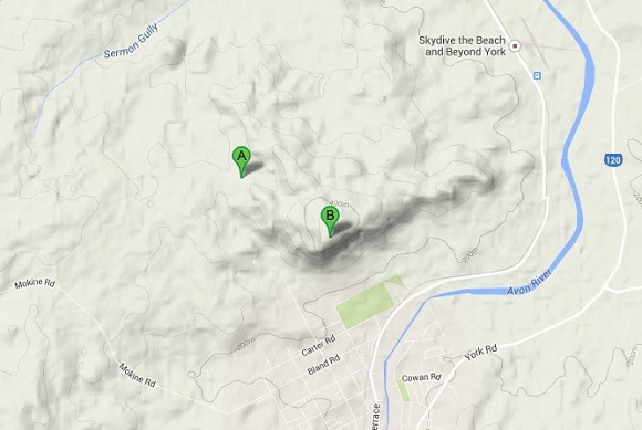
This solid 2km climb is up to a transmission tower and hang glider launch site on top of a mountain that overlooks the township of York. There is a bit of dirt road one must go on to get to ride up this one, but the views of the surrounding countryside look spectacular.
9. Bidgoods Rd: Barnawartha North, VIC
Length: 2.1km
Average gradient: 9.8%
Category: 3
This road, which shoots up off the old Hume Hwy (Plunkett Rd) looks like a rather gorgeous steep climb. Follow Black Range Rd and the road will transition from dirt to sealed.
8. St Lawrence-Croydon Rd: QLD
Length: 2.4km
Average gradient: 10%
Category: 3
20km from St Lawrence and 13km from the Sealed Bruce Hwy, there is one seriously super steep section of sealed road. According to Google Maps we have a kilometre of 20% action here. There are bailout points for vehicles going down the hill, with ramps installed to prevent disaster. All indications therefore suggest this would be a beauty!
7. Mt Goonaneman: Golden Fleece, QLD
Length: 6.8km
Average gradient: 6.4%
Category: 2
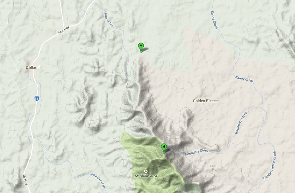
100km south of Bundaberg is this little gem. 4.5km from the turn-off on the Isis Hwy, is the start of the Mt Goonaneman Climb. The road is sealed all the way from what we can tell.
6. Mt Cenn Cruaich: NSW
Length: 4.4km
Average gradient: 8%
Category: 2
TV towers sit atop this mountain. The last 4.4km of road here leads to what appears to be a great climb, finishing higher in altitude than the nearby Siding Springs telescopes. Be sure to visit the nearby Hickeys Falls at the start of the turn-off road.
5. Bombowlee Creek to Brindabella Rd: NSW
Length: 23.9km
Average gradient: 3%
Category: 1
This section of road has been ridden a few times but nobody has put this whole link into Strava as a single climb. It looks to be an amazing piece of tarmac heading along the most direct path from Tumut to Canberra.
4. Selwyn Snowfields from Goat Ridge Rd: NSW
Length: 23.6km
Average gradient: 4%
Category: HC
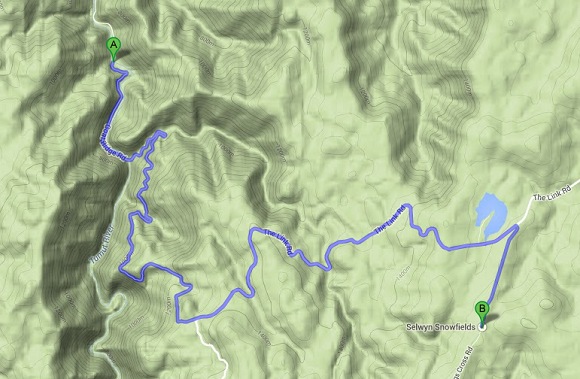
Now that the climb to Cabramurra has been added to Strava (although I feel you could keep climbing by finishing at the radio tower at Cabramurra for an extra 90m vertical), this alternative also beckons. I could imagine the three major NSW ski fields (Selwyn, Thredbo and Perisher) having the major climbs to get to them as an additional challenge to the 3 Peaks. Anyone game for the 10 peaks challenge?
3. Happy Valley Rd: Cabrumurra, NSW
Length: 6.8km
Average gradient: 10.1%
Category: 1
You have to descend this one first to climb out from the power station along the Tumut River. Seriously steep stuff in a very remote neck of the woods.
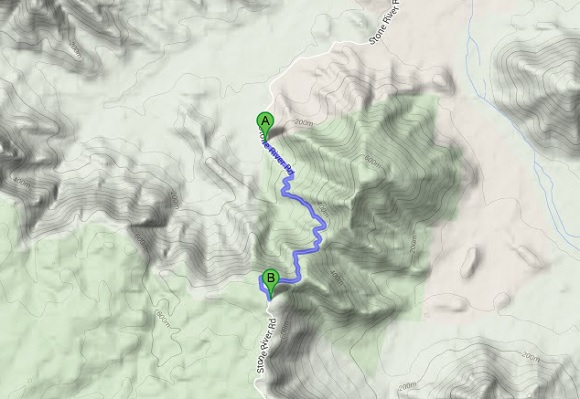
2. Stone River Rd: Upper Stone, QLD
Length: 5.5km
Average gradient: 10.5%
Category: 2
This climb can be found just out of Ingham. There is 4.7km of dirt road to negotiate, then it is pure bitumen steepness!
1. Mt Alma: Raglan, QLD
Length: 4.9km
Average gradient: 11.2%
Category: 2
This climb is found about 60km away from Gladstone in Queensland. Mt Alma is the site of a weather and aircraft radar.
This is a climb that, we think, would make Mt. Baw Baw look easy. From what we can tell, there is a mix of sealed road and gravel to negotiate up this climb. The first kilometre averages 16%, the second kilometre is at 20%. Thus at the 2km mark (which appears to be all sealed), you are well over 100m above the first 2km of Baw Baw from the Gantry, if you were to put the profiles of the two climbs side-by-side!
The road then turns to gravel as it flattens out and even descends for a little, before becoming a mix of sealed and unsealed for the last 2km and kicking up (sharply in some points).
Getting to this climb looks to be a little bit of a challenge. The way that we have recommend is to do the following: go 4.6km south on the Bruce Hwy from the Raglan Tavern. Turn right on to Gentle Annie Rd for 4.6km. Turn right on to Old Station Rd for 9.6km. Turn left on to the unmarked track for 16km to get to the start of the sealed section.
Disclaimer: We don’t know if there are gates in the way and have no knowledge if this road is open to the public and no absolute knowledge of the road condition. Please use caution for this one.
So there you have it. 10 climbs that currently aren’t on Strava. Who is game to go out and claim these mountains as their own? Happy climbing and good riding.
More from The Climbing Cyclist
 February 21, 2013 DD13: the 2013 Melbourne Dirty Dozen
 May 18, 2012 Group ride: The Dirty Dozen (all welcome)
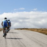 March 30, 2012 Ride Hard to Breathe Easy: prologue
 January 3, 2010 Let the training begin
 March 15, 2012 Episode 19: 3 Peaks Challenge 2012
In November 2014, I mapped out a dirt road ride between Benalla and Mansfield. My route included two “classic” climbs. When I uploaded my ride to Strava, I was surprised that the climbs weren’t defined as segments. I created the segments and claimed the KOMs. I don’t think anyone else has ridden my climbs since. Get out there and steal my soft KOMs. They are great climbs.
https://www.strava.com/segments/8460958 and https://www.strava.com/segments/8460937
For those who are on their way to Baw Baw for the Domestique ride – Elton Rd Neerim is up for grabs. It’s 1.7km @ 10.6%
http://goo.gl/maps/Qzisu
Wow, only two attempts: https://www.strava.com/segments/4201221
The nearby “Jacksons Track” from Longwarry to Neerim is a brilliant cycling route btw.
Pretty sure that sealed section of Bidgoods Rd is private property.
Edit: actual name seems to be ‘Milos Private Track’ so a fair guess it probably is. Doesn’t seem to run along a road easement and is surrounded by freehold.
‘that aren’t on Strava’… until now!
Hmm, I’d like to see just one sealed climb in Vic that isn’t on Strava!
(Oh and Bidgoods Rd climb is here: https://www.strava.com/segments/3687293. Not sure when the segment was created.)
The Bidgoods segment is only the dirt road leading up to the sealed section. Have a look at the map and you can see the sealed road when you click on to a satellite view.
Fair enough, but there must be 100s of dirt road climbs that aren’t on Strava, for reasonably obvious reasons (if you’re going to ride on dirt, there’s almost certain a track that’s more fun to ride on than a road!)
Oh I misread sorry, it’s the sealed section there’s no Strava segment for. Someone will have to try it and determine if it’s worth all that dirt to get to it!
https://www.strava.com/segments/3687294 ?
(I actually just spend a few minutes looking around for where there might be a good long climb not on Strava yet, and found this google maps street view that just made me want to leave my desk, stick the bike in the car and head straight out there: https://www.google.com.au/maps/place/Tarra-Bulga+National+Park/@-38.461006,146.54815,3a,75y,195.29h,72.14t/data=!3m4!1e1!3m2!1sClxT39554ZBcr5gyHg5qtQ!2e0!4m2!3m1!1s0x6b29420425e991ed:0xf0579a51442d880?hl=en
Amazing that only 47 people have tried it: https://www.strava.com/segments/3286572)
Found one: https://www.strava.com/routes/1404471
There are a few small Strava segments along it, but most of it isn’t covered. I’ve driven this road, it’s pretty spectacular.
Dyan, the Tarra-Bulga climb (Tarra Valley Road to Balook) is one of the nicest and most picturesque in Victoria, I would highly recommend it to you.
I did it a few weeks ago, and it was truly spectacular. Already itching to go back (Especially because someone stole my KOM by a few seconds!)
Timbarra Rd – Buchan 17.2km@2.4% http://goo.gl/maps/DJBtN
Budgeree Rd – Boolarra 11km @ 3.5% http://goo.gl/maps/8BZfJ
Snowy River Rd – Suggan Buggan 3.8km @ 6.8% http://goo.gl/maps/5HwGs
Side Road off Skyline Rd – Eildon 3km @ 7.8% http://goo.gl/maps/ALJWl
Mt Lady Franklin – Barnawartha (Short sealed Section) 700m @ 15.7% http://goo.gl/maps/bB6Th
Rubicon Rd 7.5km @ 2.3% http://goo.gl/maps/YcJzc
Elton Rd – Neerim 1.7km @ 10.6% http://goo.gl/maps/Qzisu
I can add more. The last one is good for a visit on the way to Baw Baw…