UPDATE: I’ve created a ride guide that gives you realistic checkpoints to aim for, whether you’re hoping to finish in 8,9,10,11,12, or 13 hours. Please note that this is just a guide: everyone’s ride will unfold differently. Don’t worry if you lose time on one sector — you might well make it up on another. Click here to download the guide. Please let me know if you spot any errors! Thanks to everyone that helped put this together!
You would have seen by now that the route for this year’s 3 Peaks Challenge has been altered as a result of bushfires and, most recently, landslides. Bicycle Network Victoria has published the new route but you might well be asking yourself: ‘how does this compare to the original route?’ And more importantly: ‘what can I expect from 3 Peaks now that the route is different?’
At first blush, the revised route appears to be easier than the classic 3 Peaks route. The first climb, Tawonga Gap, is the same as in the original route. But Mt. Hotham has been replaced by Mt. Buffalo and the Back of Falls has been replaced by the more popular Mt. Beauty to Falls Creek climb.
Mt. Buffalo is certainly an easier climb that Mt. Hotham — it’s 10km shorter and has none of the steep ramps that make Hotham the beast that it is. And while the Mt. Beauty to Falls Creek climb in the revised route is longer than the Back of Falls climb — 30km vs. 23km — the former doesn’t have the nasty 9km opening section that makes the Back of Falls so hard (particularly after 200km).
If you take a look at the profile below, you will notice the addition of another small climb in the revised route — Rosewhite Gap. It’s about 4km long and while it looks it’s an extra climb, the original 3 Peaks route also features a 4km climb just after Omeo — a climb that most people forget about as they anxiously approach the Back of Falls.
Don’t worry: those elevation figures aren’t accurate.
So, the revised route is certainly easier but there’s no doubt it’s still going to be a very tough day. Starting a long climb with 200km in your legs is never easy and when it’s the long Falls Creek climb you’re up against, it’ll be far from a walk in the park.
As I did a few weeks ago, before the route was changed, I’ve written up a section-by-section guide to the 3 Peaks Challenge so you know what to expect. I find that rides of this length become much easier — at least mentally — if you break them up into bite-sized chunks. Get through one section, give yourself a pat on the back then move on to the next section. Don’t think about the ride as one, long 230km epic — you’ll only intimidate yourself and start to feel demoralised.
A huge thank-you to Josh Goodall who was good enough to write the parts of this post that covered sections of the course I haven’t ridden before. Josh has trained for and raced in the Tour of Bright on these roads so I thought he’d do a great job, and he did. Thanks very much Josh!

Section 1: Falls Creek to Tawonga South
Distance: 34km
The day starts with the long descent from Falls Creek to Mt. Beauty. With nervous energy and adrenaline pumping through your body, you might be inclined to push hard on the descent. Don’t. You’re better off just turning your legs over gently, getting warmed up and making sure you get through the descent safely.
After 13km of descending you’ll cross the East Kiewa River and for the next 13km or so the road is quite undulating. Take it easy on the descents and just spin comfortably up the short climbs. After roughly 25km you’ll reach a left-hand bend after which it’s another 4km downhill into Mt. Beauty. Enjoy it!
From Mt. Beauty to Tawonga South — and the start of the first proper climb — is largely uphill. Again, use these early kilometres to get your legs warmed up and to find a comfortable rhythm. No use burning yourself out before you’ve even ticked the first peak off the list.
Section 2: Tawonga Gap climb (peak #1)
Distance: 7.6km
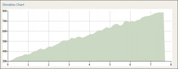
After 34km you’ll turn left onto the Tawonga Gap Road and from there it’s 7.6km to the top of the first of the 3 Peaks. At an average gradient of around 6% it’s a tough little climb and with virtually no flatter sections to speak of, it’s important to find a comfortable rhythm early.
While the gradient is quite consistent throughout, there are a number of hairpin bends where the gradient increases quite noticeably. Two such corners can be found in the first 3km of the climb.
It can be fun tackling this climb in a small group but make sure you’re climbing at a pace that’s comfortable for you. There’s no point putting yourself in the red just to keep up with other riders if it means you’ll hit the wall within the first 50km of the ride. Remember, this is the first (and easiest!) of the 3 Peaks so make sure you’re saving plenty of energy!
There’s a small rest stop at the Tawonga Gap so once you summit the climb you can take the opportunity to refill your bottles and/or grab something to eat. Of course, if you’re feeling good you can push into the next section of the course without stopping. Either way, make sure you give yourself a little pat on the back (safely) as you start to roll towards Germantown.
One down, two to go.
For more information about the Tawonga Gap climb, visit this page.
Section 3: Tawonga Gap to Mt. Buffalo tollbooth
Distance: 32km
The descent from the Tawonga Gap to the Great Alpine Road is one of the most enjoyable in the Victorian Alps. Unlike most roads in the Alps, corners on this particular descent are nicely cambered, giving you a nice, fast and flowing descent.
Enjoy yourself as you bomb towards Germantown but remember to stay safe, and look out for other riders around you. The descent flattens off somewhat after about 6km of descending (roughly 47km into the ride) but you’ll still be able to maintain a high speed in the next 8km.
After 55km you’ll reach the small community of Germantown. From here you’ll take a right turn and follow the Great Alpine Road for six flat kilometres to Bright and from there through to Porepunkah (another 6km). At Porepunkah you’ll reach a very large roundabout at which point you head straight ahead onto the Mt. Buffalo Tourist Road.
The 6km from the roundabout to the start of the climb might look flat on the profile (compared to Mt. Buffalo) but they’re not that easy. There’s a couple annoying sections of climbing that slow you down before you hit a crest and descend towards the Mt. Buffalo tollbooth.
Section 4: Mt. Buffalo climb (peak #2)
Distance: 21km
There’s no doubt that climbing Mt. Buffalo is easier than Mt. Hotham, but don’t get me wrong: this climb will still make you suffer. The revised route has the climb finishing at the Mt. Buffalo Chalet which is about 21km from the tollbooth. There’s a slightly flatter section after 7.6km of climbing, and a brief downhill and flat section after 18.4km of climbing but apart from that, the climbing here is very steady and consistent.
The gradient hovers around 5% most of the way up meaning it’s reasonably easy to find a comfortable rhythm.
One thing that Mt. Buffalo and Mt. Hotham have in common is incredible scenery and sweeping vistas. Try to look around every once in a while when you’re climbing Mt. Buffalo — from the stunning gorge after 1.5km of climbing, to the sheer rock faces and ferny-roadside sections, this really is a stunning climb.

To get to the Mt. Buffalo chalet once you reach the plateau (after 18.4km of climbing) you’ll need to take a left and climb for another 2km.
There is a rest stop at the chalet so make sure you’re adequately fed and hydrated before turning around and starting one of the best descents in Victoria.
For more information about the Mt. Buffalo climb, visit this page.
Section 5: Mt. Buffalo to Ovens
Distance: 46km
After the descent of Mt. Buffalo you’ll be deservedly patting yourself on the back, with just over half the distance already in the bag. After returning to the big roundabout in Porepunkah you’ll head left along an enjoyable false-flat, pointing ever so slightly downward for 19km to the township of Ovens.
The surface is usually in good shape with occasional rough patches; there’s sometimes mud or dirt on the blacktop, and you may even encounter the occasional bovine. There isn’t much else to see.
Livestock and mud notwithstanding, many people will make great time along this stretch. It’s probably even worth waiting a few minutes in Porepunkah or soft-pedalling towards Ovens in order to get swept up by a group. You’ll save a lot of energy sitting in the bunch — energy that you’ll be glad of later. But don’t be a wheelsucker — get out into the wind and do your turn. The whole group benefits if everyone’s helping out.
Section 6: Ovens to Running Creek
Distance: 34km
A sharp right at Ovens onto the delightfully named Happy Valley Road heralds a change in scenery. You’ll be following some gentle undulations upward through woodland for about 15km before the third climb of the day takes you up and over Rosewhite Gap. Holding a steady grade for most of the way — an average of 4.2% for 4.3km — the climb of Rosewhite is hardly a major challenge compared to the rest of the day’s adventure.
But with two substantial climbs already under your belt and plenty of road left to go, you’d be wise to spare your legs by spinning a lower gear with a higher cadence (80-90rpm). Be sure to enjoy this steady climb through temperate forest!
The climb of Rosewhite Gap ends at a bus shelter in a gravel bay. From here it’s a sharp left into the descent. The surface of the Happy Valley Road is mostly very good, but you should still take care to avoid the occasional surprise pothole or debris. The corners and grades on the way down are not as challenging as those of the peaks behind you, although most of us will still need to pay attention and touch the brakes occasionally.
In good conditions this all adds up to a flowing descent on smooth hotmix and can be one of the highlights of the day. It’s also the last hill descent of the ride so enjoy it while you can.
At the bottom you’ll roll into the Running Creek food valet stop. Stock up on food and drink before heading off towards Mt. Beauty and the final challenge of the day.
Section 7: Running Creek to Mt. Beauty
Distance: 26km
After turning right onto the Kiewa Valley Highway the road becomes quite undulating. There are only a few flatter sections and you’ll want to be carefully rationing your strength. After Running Creek it’s a 26km push to the town of Mt. Beauty and hitting the rollers too hard will sap your energy.
Even the one or two false-flat sections can feel like a drag; it’s all trending slightly upward, but there’s something to keep you going . As you progress there’ll be ever more frequent, tantalising glimpses of the mountains ahead.
When you reach Mt. Beauty, take a moment to get enough food and drink on board before you embark on the final climb of the day: the 30km ascent to Falls Creek.
Section 8: Falls Creek climb (peak #3)
Distance: 30km
Once you’ve fuelled up, taken a deep breath and composed yourself, it’s time to hit the final challenge of the day: the long climb back up to Falls Creek. It’s the longest climb of the day, and with 200km in your legs before you start, it’s going to hurt.
The good thing (or maybe bad thing, depending on how you look at it ) is that finishing the day with this climb will be easier than finishing with the Back of Falls (as per the original route). Not only are there a few downhills and flat sections in the first 16km of the Falls Creek climb, but there’s no horrendously steep opening section as there is on the Back of Falls.
That said, the climbing does start as soon as you leave the roundabout in Mt. Beauty. It’s a solid 4km uphill before you reach a sharp right-hand bend and the first bit of respite for the climb. As you can see from the profile below, the road definitely tends upward throughout, but every so often you’ll get a nice little downhill or flat section where you can rest and recover.
While you’ll likely be quite sore by the time you’re climbing Falls Creek, do take the time to look around and enjoy the scenery. It’s a stunning climb throughout and there are some magical views on the left-hand side of the road in the first 16km or so.
About 16km after Mt. Beauty you’ll pass the Bogong Alpine Village and start a nice descent towards the East Kiewa River. After you cross that bridge it’s about 13km to the top, almost entirely uphill. There are one or two spots where it flattens off very briefly but as you can see from the profile, you’re basically climbing all the way to Falls Creek.
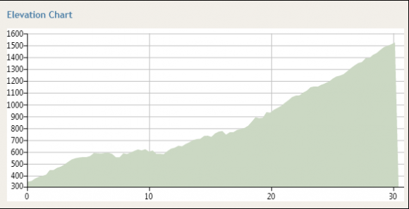
That said, the gradient is a manageable 5-6% and it should be easy enough to find a slow but steady rhythm. About 9.4km from the bridge (and about 25km from Mt. Beauty) you’ll pass the Falls Creek tollbooth at which point the road seems to get fractionally steeper. It’s not a huge increase, but at the end of the long climb and a very long day, you’ll be feeling it.
But not long after passing the tollbooth you catch your first glimpse of the Falls Creek village. Being able to see your final destination is a great incentive and you’ll likely find a little bit extra in the legs as you push towards the finish.
The road from the entrance to the Falls Creek village to the finish line is slightly steeper than the climb to Falls Creek but by that point you really won’t care. The job is done. You’ve ridden 230km, climbed roughly 4,000 vertical metres and completed the 2013 3 Peaks Challenge. Congratulations!
For more information about the final 13km of the Falls Creek climb*, visit this page.
Final thoughts
So that’s what you can expect from the course. Of course the weather will play a huge part in how the day pans out and I suspect we’re all hoping for a clear, dry day with temperatures in the mid-to-high 20s. Regardless of the forecast, make sure you’ve got a rain jacket with you — the weather in the Alps can turn bad faster than you might think.
So how do you rate the revised course? Personally, I’m not as disappointed as some people — I’ve done the original 3 Peaks route twice before and riding this route will give me a chance to see some roads I haven’t yet ridden. It’s a shame that the original course isn’t a viable option this year — especially for those that haven’t completed it or are travelling a long way to get there — but I’m not sure much more could have been done by Bicycle Network Victoria or the relevant emergency services.
Good luck to everyone that’s riding 3 Peaks this Sunday — I hope you have a safe and memorable day. Even if you’re a little disappointed about the route change, try to enjoy the day — it’s a challenging but rewarding ride on some of the best cycling roads Victoria has to offer. What’s not to like about that?
Thanks to Emma Bolger and the Bicycle Network Victoria team for inviting me up to Falls Creek to attempt the 3 Peaks Challenge once more. I’m very much looking forward to the ride and grateful for their support.
*


Hi
Are you able to help me please. Is there a website that we can use to track/follow the cyclists’ progress tomorrow?
Many thanks
Jane
Omg, that ride guide is phenomonally awesome!
Thank you. *blush*
I’m happy to see that you’re going to edit the Falls Creek entry on the site. I think the first half until you hit the Kiewa River is definitely worthy of inclusion on the climb, despite the flat and downhill sections. Otherwise, you could make an argument that Hotham is only as long as the top of the mountain before you descend to start CRB Hill.
Good luck with the 3 Peaks. I honestly don’t know why people are complaining about the route. The emergency services did a tremendous job just preventing Hotham Heights from burning down. People are acting a bit spoilt in my opinion. I don’t reckon this is as hard as the original but it won’t be a walk in the park. Buffalo, whilst stunning, is still a tough climb (higher average gradient than Falls or Hotham) and don’t underestimate the effect Rosewhite Gap will have on you. Whilst its not long or steep, you don’t want to be pushing too hard there, only to run out of steam on the way back to Mount Beauty or going up Falls.
Im not sure if I am calculating the times incorrectly but I am hoping to finish the ride in 13 hours although if I follow the suggested time split Im going to miss the the Mt Beauty cut off by 40 minutes? Have I made in error is the the ride guide (page 13) incorrect?
What they have done is just cut and paste the sector times from the 2012 Ride Plan. All in all it will be quite confusing for riders targeting 13 hours for the reason you have mentioned. In addition, other sectors make no sense such as 2 hours to descend Mt Buffalo to Porpunkah (for the 13 hour riders) and then after this leisurely roll they will need to average 39.9km to Ovens. I would ignore.
Excellent write up and very helpful indeed to my preparation, thank you!
I, like you, have ridden the 3Peaks Challenge twice already, so I have mixed feeling about the new course.
On the one-hand I’m genuinely excited about tackling two climbs that I haven’t ridden before (Mt Buffalo and the front of Falls). A friend of mine has said that Mt Buffalo is a stunning climb, so how can I not look forward to that? On the other hand, even though the new course does seem to be a smidge easier, I do lose the benefit of course familiarity, and the ability to benchmark this year’s ride against my previous efforts.
In an odd way I’ll also miss The Meg, WTF corner, the first 10kms of the BoF etc. Those legendary sections are the sections that stir the most memories for me from the previous two years.
The long range weather forecast has been looking good all week, so probably my biggest fear is the descent off Buffalo. Two factors, firstly it’s along the same road that we climbed it, and secondly I hear that the field has increased to 1,500 riders this year. I hope that section is well marshaled, otherwise it could be carnage!
All-in-all, I’m looking forward to a great day, and hats off to Bicycling Vic for having such a great contingency plan ready to roll-out.
I wouldn’t fear the descent of Buffalo too much. Apart from when its hot and the road melts a bit (which doesn’t effect grip too much), its pretty straight and open, which means you get plenty of chances to have a look at the road in front of you. It’s one of my favourite descents because you can carry a lot of speed throughout.
My only issue would be descending whilst people are coming up as you may get some people on the wrong side of the road (a.k.a. carnage).
This is absolute Gold. Thanks a bundle. I did bits of this course years ago in the Tour of Bright (not Falls, and not in one day), and am looking forward to this year’s 3 Peaks. It will be my first and the nerves have started to set in. A quick point though – don’t rely on the times in the BV Ride Guide. They are wrong. For example, it takes longer to get down Buffalo (2hrs to Porepunkah on the 13hr plan) than it takes to get up. Even a slow rider will do it in less than an hour. Best to work out your own ride plan. Good luck everyone. Ride well.
Hi Mark.
Yeah, I spotted that. I agree with you, but the anomaly might not be as dramatic as it first seems.
I’m pretty sure that the ride guide “stops the clock” as you crest Buffalo and, looking closely at the mapmyride profile, you still have about 10km (at least) riding the rolling terrain on the plateau at the top of Buffalo.
Put another way, the “top” of the climb (as listed on the ride guide) isn’t the point at which you turn back.
Still, I think you’re right, it seems like a conservative estimate. That said, given there will be riders climbing up while I’m riding down I won’t look upon this sections as a place to make up time!
This being my first 3 peaks and with us about to embark on the 1000 kay drive just to get to the start line… and in light of knowing everything has been done to stick to the original route… I have to admit to still being a little disappointed not to be doing Hotham and BoF. Does anyone know if finishing BoF was/is a viable option at all? I can’t help but wonder if 2013 will be the year which has a asterisk associated when saying you’ve ridden 3 peaks. I guess we’ll all soon find out.
However in saying this 230 kays and 4k metres is still 230 kays and 4k metres, so she’ll still be one very tough day in the saddle. And I’m sure if all things go to plan any disappointment which I might be feeling now will quickly fade on landing in the Falls Creek Village.
Godspeed.
Simon
Nice write up Matt. My only comment would be on the Porepunkah to Ovens leg….”There isn’t much else to see.” We rode that way on the Gaps Loop a few weeks ago and its a delightfully scenic bit of road…hop fields, fruit trees, Buffalo looming in the distance, squadrons of enormous helicopters taking off from the DSE headquarters to go fight the Hotham fire, disused railway stations, wineries, nonchalant cattle. Having said that, we did it with fresh legs at 8 o’clock in the morning. Most people on Sunday will just be staring at the road wishing they were in the swimming pool at Mt Beauty!
Our group were a little sad’nd by the change in route, but realistically it probabily suits us a little better as we may have started our training a little late as work always seems to get in the way! What we are are looking forward to mostly is the interstate boys trip away with some kays on the bike in one of the beauiful parts of our country!
Bring on next weekend!!!!
Thanks Matt, very helpful. Long-time lurker here. Your previous write-ups were a big help in getting me round the loop the last couple of years and this is a big help again.
Thanks Matt. 🙂
Thanks for the tactical rundown Matt. Yeah the new climbs are a new challenge in their own right.
I do like the way BOF does my head in – but that joy will have to wait another year.
Kudos to the organisers in a very difficult situation.
Thanks matt very helpful write up.personally I’m looking forward to the revised route, not just because we avoid the back of falls also the chance to ride new peaks and rose white gap. Should BV swap the route each year?
To me, the appeal of 3 Peaks – aside from the challenge – is that it’s a chance to ride great roads that are difficult to ride otherwise.
In my view, it’s not wise to be riding Back-O-Falls or the Omeo Highway unsupported; it’s pretty lonely country, a lot of it is out of mobile range, and the weather can turn very nasty very quickly even in mid summer.
Buffalo and front side of Falls, by contrast, are pretty safe; if the weather looks dodgy you turn around and 20 minutes later you’re back in town; worst comes to worst you make a phone call and ask for help. So you don’t really need support to tackle them.
Not blaming BV for a second for changing the route; if the road’s not safe, it’s not safe, and this will still be a great day out. But I’d prefer the original route.
Additional to Matt’s excellent rundown, the Buffalo road can melt if it gets hot; better descenders than I claim that this doesn’t really affect the grip levels but it’s pretty disconcerting to say the least.
Have fun everyone.
Thanks Matt. Really appreciate this as we haven’t ridden any of these roads. So whilst the original 3 peaks route had loads of info on it, the revised route had us feeling like it was going to be stab in the dark.
Thanks again. chris
Pleasure Chris! Please spread the word. 😉
Thanks Matt. I was hoping you would write this. And thanks Josh for helping.